Live Post: Shelby / Jefferson County Tornado Warning
No longer updating this post. Please look for new posts.
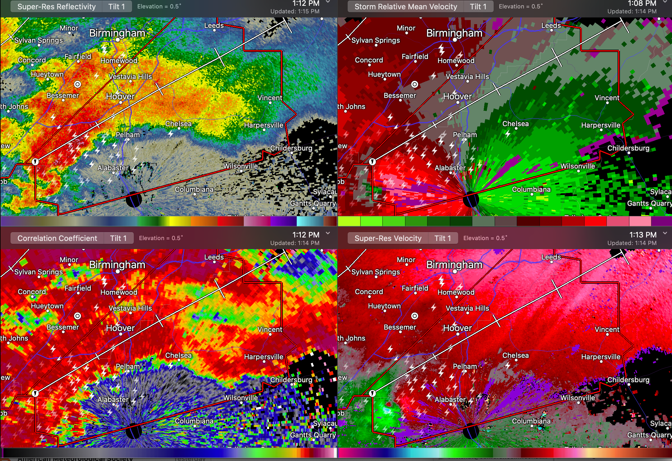
Here is a running blog post of updates on the confirmed tornado in southwestern Shelby County.
UPDATE 151 PM
The tornado is nearing Dunavant and Vandiver in northern Shelby County.
It will pass just south of Leeds and cross I-20.
Tornado is definitely still on the ground.
There is damage reported at the PelhamThe tornado Civic Complex.
Damage in Old Town Helena.
There is extensive damage in Heardmont Park. There was damage to the Football Stadium at Oak Mountain High School.
UPDATE 147 PM
The camera atop the Grandview Medical Center confirms a large, destructive tornado just passed near US-280 and 119 at the bottom of Doouble Oak Mountain.
This tornado is moving parallel too 119 along Shelby Cunty Highway 41,
UPDATE 140 PM
Damage is being reported in Helena. Pelham Fire is reporting multiple calls for assistance.
A confirmed large and extremely dangerous tornado is on the ground near Highway 119 in northern Shelby County.
The NWS in Birmingham has issued a TORNADO EMERGENCY for Shelby County…
…TORNADO EMERGENCY FOR SHELBY COUNTY…
…A TORNADO WARNING REMAINS IN EFFECT UNTIL 200 PM CDT FOR
NORTHEASTERN SHELBY AND EAST CENTRAL JEFFERSON COUNTIES…
AT 136 PM CDT, A CONFIRMED LARGE AND DESTRUCTIVE TORNADO WAS LOCATED
OVER INDIAN SPRINGS VILLAGE, OR NEAR HOOVER, MOVING NORTHEAST AT 45
MPH.
TORNADO EMERGENCY FOR HWY 280 LEE BRANCH. THIS IS A PARTICULARLY
DANGEROUS SITUATION. TAKE COVER NOW!
People along highway 119 to US-280 including Lee Branch, Meadowbrook, Brook Highland, Lake Purdy, and Shoal Creek need to be in Shelby County.
UPDATE 134 PM
The NWS in Birmingham is adding a CONSIDERABLE damage tag to the tornado warning. This is a potentially strong to violent tornado that will cause considerable damage.
Debris signature has now reappeared.
Everyone in the tornado warning polygon needs to be in safe shelter.
Calera and Helena are all clear now.
UPDATE 127 PM
Take cover Helena!!!!
The radar signature is definitely ramping back up. There is a strong rotational couplet. It is likely producing a tornado.
UPDATE 116 PM
A dangerous storm with a tornado that has produced damage is now approaching Helena and Pelham.
The tornado will pass very near downtown Helena and Pelham. Hotels, businesses, and residences near the Oak Mountain Amphitheater at 119/I-65 need to be in safe shelter.
There has been damage at West Blocton in Bibb County.
People along 119 from I-65 to US-280 should be in safe shelter. People in Meadowbrook, Lake Purdy, and Shal Creek need to obe in safe shelter now.
Category: Alabama's Weather, ALL POSTS, Severe Weather
About the Author (Author Profile)
Bill Murray is the President of The Weather Factory. He is the site's official weather historian and a weekend forecaster. He also anchors the site's severe weather coverage. Bill Murray is the proud holder of National Weather Association Digital Seal #0001 @wxhistorianSubscribe
If you enjoyed this article, subscribe to receive more just like it.


