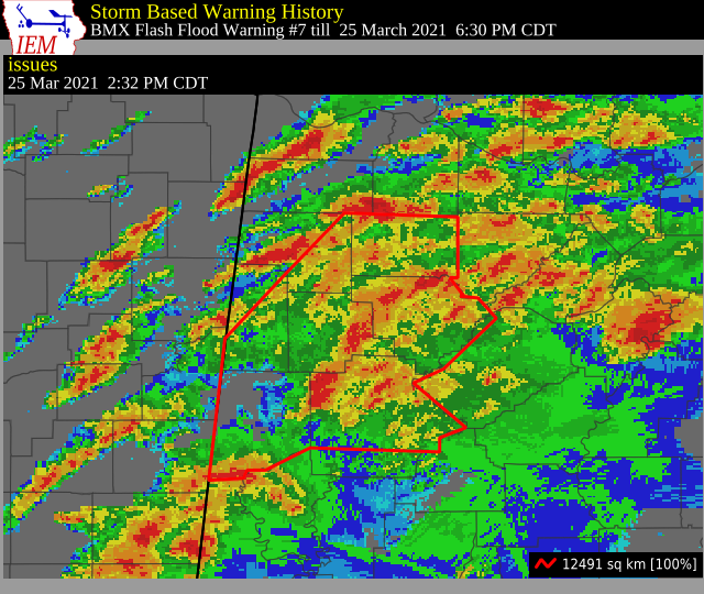
Flash Flood Warning for Jefferson, Walker, Marion, Winston, Fayette, Lamar, Pickens, & Tuscaloosa Co. Until 6:30 pm
The National Weather Service in Birmingham has issued a
* Flash Flood Warning for…
Western Jefferson County in central Alabama…
Walker County in central Alabama…
Eastern Marion County in northwestern Alabama…
Winston County in northwestern Alabama…
Fayette County in west central Alabama…
Lamar County in west central Alabama…
Pickens County in west central Alabama…
Tuscaloosa County in west central Alabama…
* Until 630 PM CDT.
* At 232 PM CDT, Doppler radar indicated thunderstorms producing
heavy rain across the warned area. Between 2 and 3 inches of rain
have fallen. Flash flooding is ongoing or expected to begin
shortly.
HAZARD…Flash flooding caused by thunderstorms.
SOURCE…Doppler radar.
IMPACT…Flooding of small creeks and streams, urban areas,
highways, streets and underpasses as well as other
drainage and low lying areas.
* Some locations that will experience flash flooding include…
Tuscaloosa, Northport, Jasper, Winfield, Fayette, Haleyville,
Sumiton, Aliceville, Cordova, Dora, Carbon Hill, Vernon, Gordo,
Reform, Millport, Carrollton, Lynn, Pickensville, Arley and Holt.
Additional rainfall amounts of 1 to 2 inches are possible in the
warned area.
Category: Alabama's Weather, ALL POSTS, Severe Weather
About the Author (Author Profile)
Scott Martin is an operational meteorologist, professional graphic artist, musician, husband, and father. Not only is Scott a member of the National Weather Association, but he is also the Central Alabama Chapter of the NWA president. Scott is also the co-founder of Racecast Weather, which provides forecasts for many racing series across the USA. He also supplies forecasts for the BassMaster Elite Series events including the BassMaster Classic.Subscribe
If you enjoyed this article, subscribe to receive more just like it.


