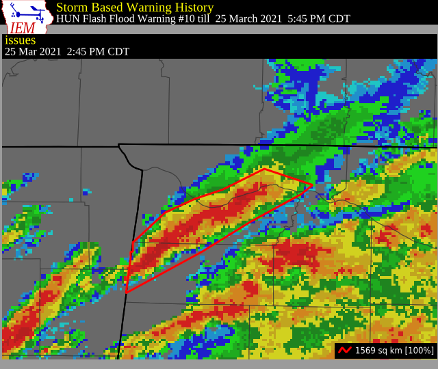
Flash Flood Warning for Colbert, Franklin, Lauderdale, Lawrence Co. Until 5:45 pm
The National Weather Service in Huntsville has issued a
* Flash Flood Warning for…
Southern Colbert County in northwestern Alabama…
Northwestern Franklin AL County in northwestern Alabama…
Southeastern Lauderdale County in northwestern Alabama…
Northwestern Lawrence County in northwestern Alabama…
* Until 545 PM CDT.
* At 245 PM CDT, Doppler radar indicated thunderstorms producing
heavy rain across Northwestern Franklin, much of Central Colbert,
and portions of South Central Lauderdale County. Thunderstorms
will continue to move from the southwest to the northeast across
these locations, producing rainfall amounts of 1 to 2 inches
within the next hour. Flash Flooding will begin shortly.
HAZARD…Flash flooding caused by thunderstorms.
SOURCE…Doppler radar.
IMPACT…Flooding of small creeks and streams, urban areas,
highways, streets and underpasses as well as other
drainage and low lying areas.
* Some locations that will experience flash flooding include…
Florence, Muscle Shoals, Sheffield, Tuscumbia, Red Bay, Killen,
St. Florian, Posey Loop, New Bethel, Red Rock, Pride Landing,
Crooked Oak, Barton, Colbert Heights, Srygley Church, Cedar Creek
Reservoir, Dempsey, Northwest Alabama Regional Airport, Mynot and
Pleasant Site.
PRECAUTIONARY/PREPAREDNESS ACTIONS…
Turn around, don’t drown when encountering flooded roads. Most flood
deaths occur in vehicles.
Category: Alabama's Weather, ALL POSTS, Severe Weather
About the Author (Author Profile)
Scott Martin is an operational meteorologist, professional graphic artist, musician, husband, and father. Not only is Scott a member of the National Weather Association, but he is also the Central Alabama Chapter of the NWA president. Scott is also the co-founder of Racecast Weather, which provides forecasts for many racing series across the USA. He also supplies forecasts for the BassMaster Elite Series events including the BassMaster Classic.Subscribe
If you enjoyed this article, subscribe to receive more just like it.


