TORNADO EMERGENCY for Shelby Co. Until 6:00 pm; Seek Shelter Immediately
…TORNADO EMERGENCY FOR COLUMBIANA…
…A TORNADO WARNING REMAINS IN EFFECT UNTIL 600 PM CDT FOR
SOUTHEASTERN SHELBY COUNTY…
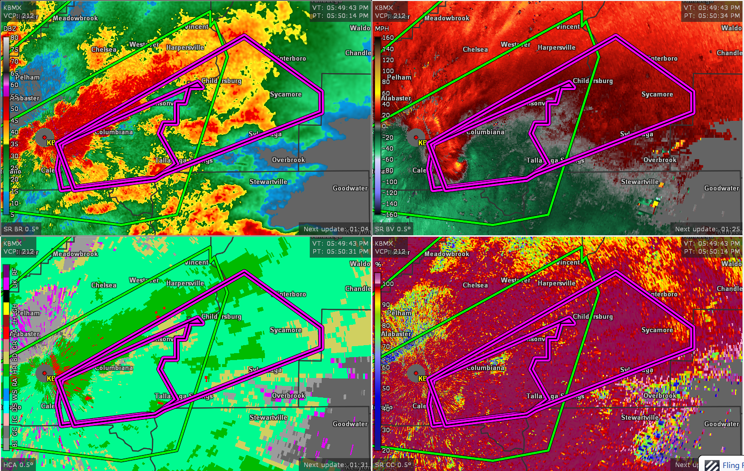
At 547 PM CDT, a confirmed large and destructive tornado was located
over Calera, moving northeast at 45 mph.
TORNADO EMERGENCY for COLUMBIANA and other locations in south-
central and southeastern Shelby County. This is a PARTICULARLY
DANGEROUS SITUATION. TAKE COVER NOW!
HAZARD…Deadly tornado.
SOURCE…Radar confirmed tornado.
IMPACT…You are in a life-threatening situation. Flying debris may
be deadly to those caught without shelter. Mobile homes
will be destroyed. Considerable damage to homes,
businesses, and vehicles is likely and complete destruction
is possible.
Locations impacted include…
Calera, Columbiana, Wilsonville, Lay Lake, Shelby, Beeswax Creek
Park, Alabama 4H Center, Gaston Steam Plant, Kelley Branch and Shelby
Shores.
PRECAUTIONARY/PREPAREDNESS ACTIONS…
To repeat, a large, extremely dangerous, and potentially deadly
tornado is on the ground. To protect your life, TAKE COVER NOW! Move
to an interior room on the lowest floor of a sturdy building. Avoid
windows. If in a mobile home, a vehicle or outdoors, move to the
closest substantial shelter and protect yourself from flying debris.
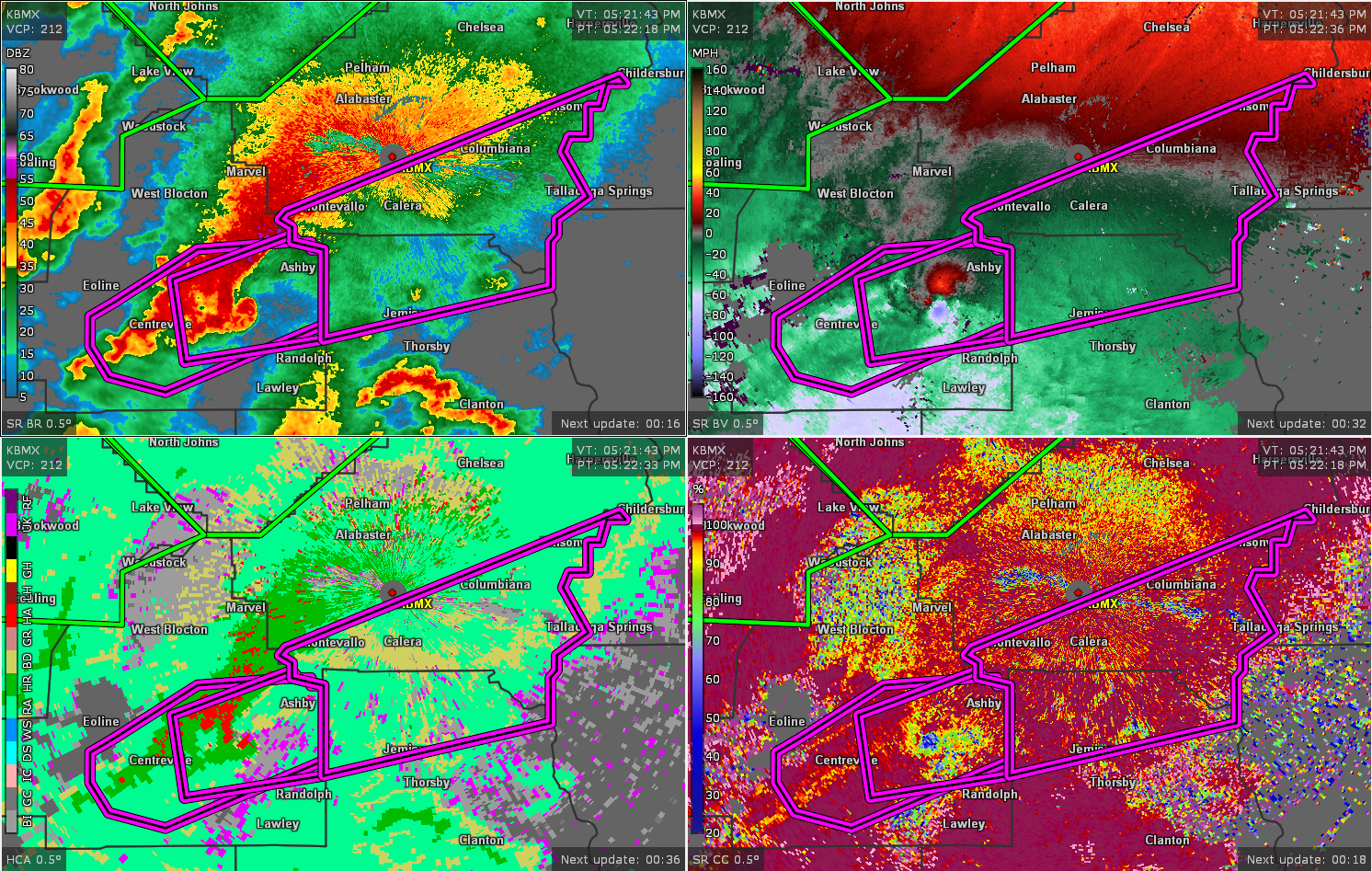
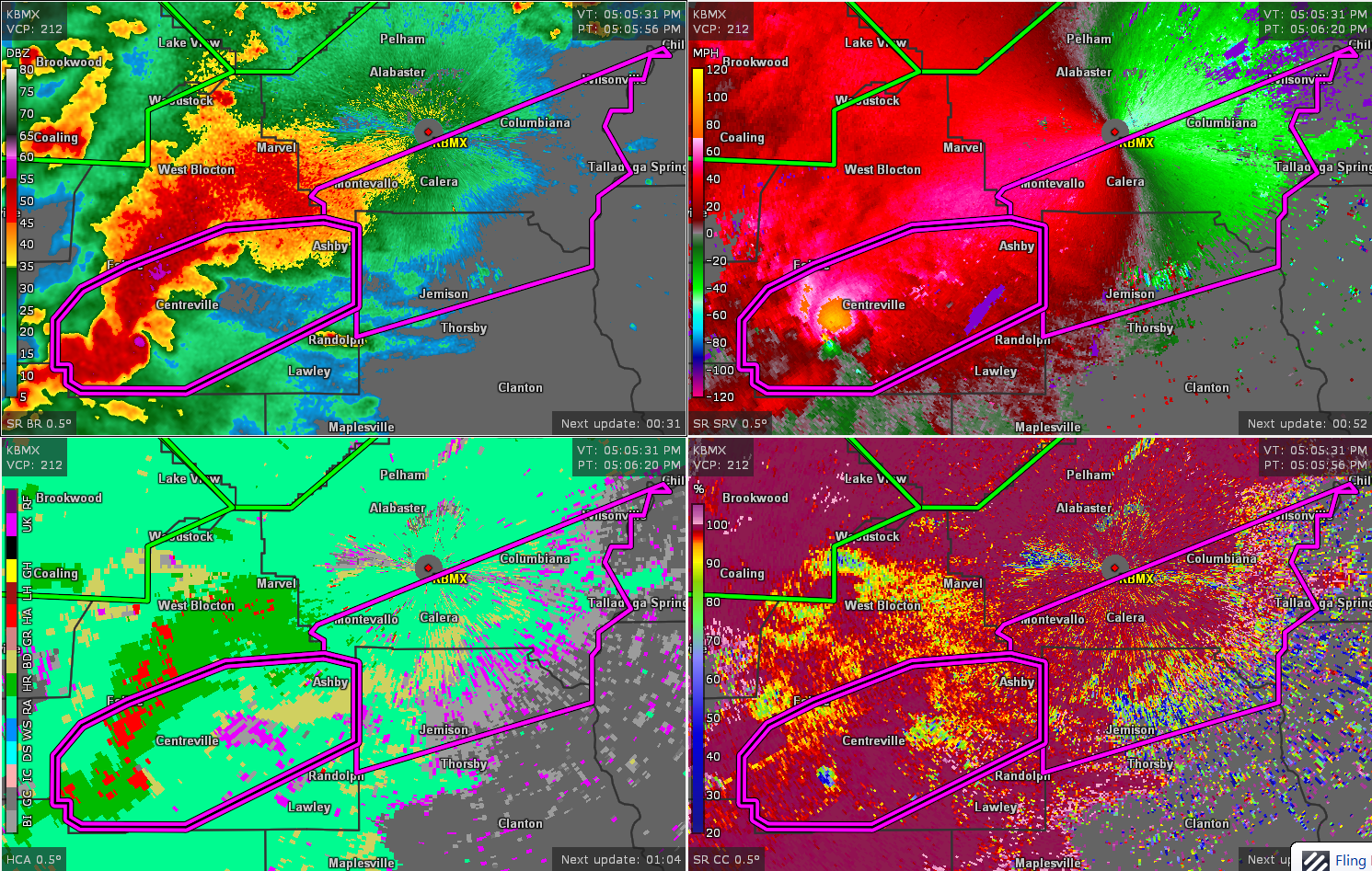
The National Weather Service in Birmingham has issued a
* Tornado Warning for…
North central Chilton County in central Alabama…
Southern Shelby County in central Alabama…
* Until 600 PM CDT.
* At 505 PM CDT, a confirmed large and extremely dangerous tornado
was located over Harrisburg, or near Brent, moving east at 50 mph.
This is a PARTICULARLY DANGEROUS SITUATION. TAKE COVER NOW!
HAZARD…Damaging tornado.
SOURCE…Radar confirmed tornado.
IMPACT…You are in a life-threatening situation. Flying debris
may be deadly to those caught without shelter. Mobile
homes will be destroyed. Considerable damage to homes,
businesses, and vehicles is likely and complete
destruction is possible.
* Locations impacted include…
Calera, Montevallo, Columbiana, Jemison, Wilsonville, Wilton,
University Of Montevallo, Lay Lake, American Village, Shelby,
Minooka Park, Beeswax Creek Park, Alabama 4H Center, Waxahatchee
Creek, Highway 145 and CR 46, Kelley Branch, Spring Creek, Gaston
Steam Plant and Shelby Shores.
PRECAUTIONARY/PREPAREDNESS ACTIONS…
To repeat, a large, extremely dangerous and potentially deadly
tornado is on the ground. To protect your life, TAKE COVER NOW! Move
to a basement or an interior room on the lowest floor of a sturdy
building. Avoid windows. If you are outdoors, in a mobile home, or in
a vehicle, move to the closest substantial shelter and protect
yourself from flying debris.
THE NATIONAL WEATHER SERVICE IN BIRMINGHAM HAS ISSUED A
* TORNADO WARNING FOR…
NORTH CENTRAL CHILTON COUNTY IN CENTRAL ALABAMA…
SOUTHERN SHELBY COUNTY IN CENTRAL ALABAMA…
* UNTIL 600 PM CDT.
* AT 505 PM CDT, A CONFIRMED LARGE AND EXTREMELY DANGEROUS TORNADO
WAS LOCATED OVER HARRISBURG, OR NEAR BRENT, MOVING EAST AT 50 MPH.
THIS IS A PARTICULARLY DANGEROUS SITUATION. TAKE COVER NOW!
HAZARD…DAMAGING TORNADO.
SOURCE…RADAR CONFIRMED TORNADO.
IMPACT…YOU ARE IN A LIFE-THREATENING SITUATION. FLYING DEBRIS
MAY BE DEADLY TO THOSE CAUGHT WITHOUT SHELTER. MOBILE
HOMES WILL BE DESTROYED. CONSIDERABLE DAMAGE TO HOMES,
BUSINESSES, AND VEHICLES IS LIKELY AND COMPLETE
DESTRUCTION IS POSSIBLE.
* LOCATIONS IMPACTED INCLUDE…
CALERA, MONTEVALLO, COLUMBIANA, JEMISON, WILSONVILLE, WILTON,
UNIVERSITY OF MONTEVALLO, LAY LAKE, AMERICAN VILLAGE, SHELBY,
MINOOKA PARK, BEESWAX CREEK PARK, ALABAMA 4H CENTER, WAXAHATCHEE
CREEK, HIGHWAY 145 AND CR 46, KELLEY BRANCH, SPRING CREEK, GASTON
STEAM PLANT AND SHELBY SHORES.
PRECAUTIONARY/PREPAREDNESS ACTIONS…
TO REPEAT, A LARGE, EXTREMELY DANGEROUS AND POTENTIALLY DEADLY
TORNADO IS ON THE GROUND. TO PROTECT YOUR LIFE, TAKE COVER NOW! MOVE
TO A BASEMENT OR AN INTERIOR ROOM ON THE LOWEST FLOOR OF A STURDY
BUILDING. AVOID WINDOWS. IF YOU ARE OUTDOORS, IN A MOBILE HOME, OR IN
A VEHICLE, MOVE TO THE CLOSEST SUBSTANTIAL SHELTER AND PROTECT
YOURSELF FROM FLYING DEBRIS.
Category: Alabama's Weather, ALL POSTS, Severe Weather
About the Author (Author Profile)
Scott Martin is an operational meteorologist, professional graphic artist, musician, husband, and father. Not only is Scott a member of the National Weather Association, but he is also the Central Alabama Chapter of the NWA president. Scott is also the co-founder of Racecast Weather, which provides forecasts for many racing series across the USA. He also supplies forecasts for the BassMaster Elite Series events including the BassMaster Classic.Subscribe
If you enjoyed this article, subscribe to receive more just like it.


