A New Tornado Watch to Be Issued Before 8 pm to Replace Current Watch
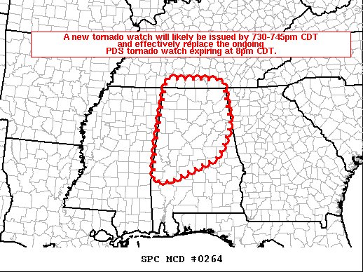
SUMMARY… A new tornado watch will likely be issued by 730-745pm CDT and effectively replace the ongoing PDS tornado watch set to expire at 800pm CDT.
DISCUSSION… Radar mosaic shows several clusters of storms across AL and a band of storms near the TN/MS/AL border as of 7pm CDT. Although a considerable amount of convection has led to rain-cooled temperatures and a reduction in instability over north-central and northern AL, a moist and adequately unstable airmass remains in place given the presence of mid 60s dewpoints near the TN border to upper 60s over south-central AL. Very strong low to mid-level flow will conditionally support updraft rotation with established/mature updrafts. It appears the overall severe risk has lessened compared to earlier this afternoon, but isolated large hail, damaging gusts, and a tornado threat will probably persist through much of the evening. It is unclear whether more than a few storms will pose a severe risk, but the environment will at least favor some potential for severe.
Category: Alabama's Weather, ALL POSTS, Severe Weather
About the Author (Author Profile)
Scott Martin is an operational meteorologist, professional graphic artist, musician, husband, and father. Not only is Scott a member of the National Weather Association, but he is also the Central Alabama Chapter of the NWA president. Scott is also the co-founder of Racecast Weather, which provides forecasts for many racing series across the USA. He also supplies forecasts for the BassMaster Elite Series events including the BassMaster Classic.Subscribe
If you enjoyed this article, subscribe to receive more just like it.


