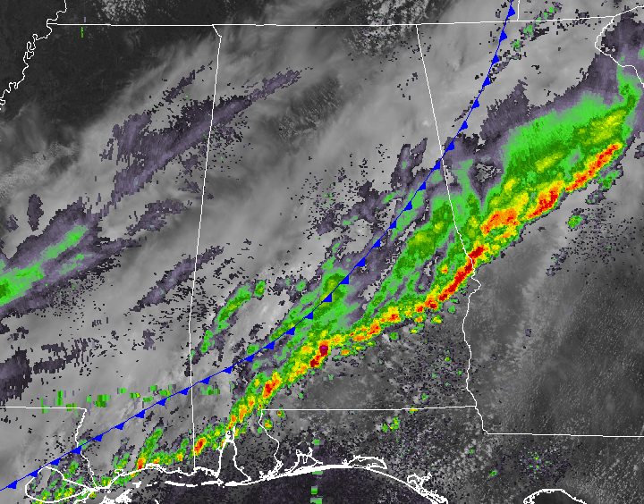
Storms Continue to Move Out at Midday; Marginal Risk Continues for Locations South of I-85
MUCH OF CENTRAL ALABAMA BEGINS TO DRY OUT
The main line of storms have pushed down to the I-85 corridor in the southeastern parts of Central Alabama, but those are staying behaved at the moment. Clouds are starting to break up to the west and into the northwestern parts of the area and some sun may be seen before we get to sunset. A few sprinkles may move across the area later today, but much of the area will dry out.
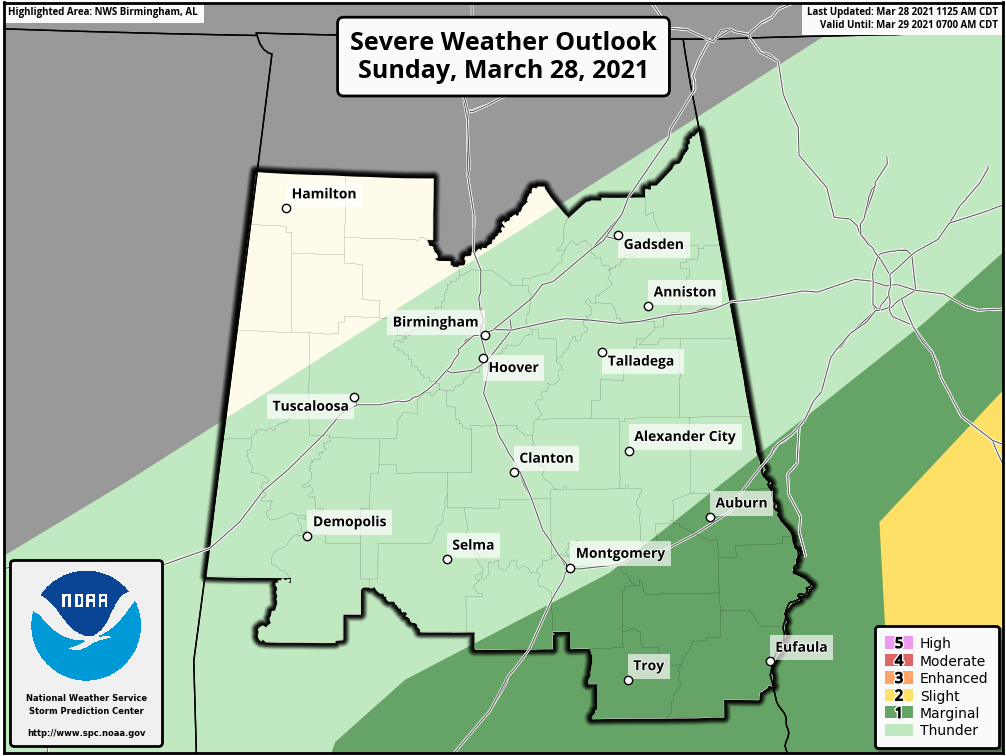
A Marginal Risk for severe storms continues for the locations along and south of the I-85 corridor in the southeastern parts of Central Alabama for a couple of more hours, but the threat will come to an end by 2:00 pm.
There may be a few lingering showers over the southern and southeastern parts of the area this evening and tonight, but all precipitation should be out of here by midnight or a little earlier. Clouds will be decreasing and lows will dip down into the upper 30s to the mid-40s,
THE WORK WEEK AHEAD
Monday will feature plenty of sunshine with highs reaching the mid-60s to the lower 70s across the area. Moisture will begin to work back into the area on Tuesday with showers possible by the afternoon and rain and some thunder becoming likely during the evening. Highs will be in the lower to mid-70s.
A cold front will bring thunderstorms to the area on Wednesday along with a low-end severe weather threat with the potential of damaging winds and large hail. Highs will be in the upper 50s to the lower 80s from northwest to southeast.
Thursday will be much cooler across the area with sunny skies and highs in the lower 50s to the lower 60s. Some frost or a light freeze may occur in portions of the area during the pre-dawn hours on Friday as lows will dip into the upper 20s to the upper 30s. Temperatures will make a decent recovery during the day on Friday with near-maximum sunshine and highs in the upper 50s to the lower 60s.
EASTER WEEKEND LOOKS TO BE NICE & DRY
Saturday will be another bright and sunny day with warmer temperatures as highs will get up into the mid-60s to the lower 70s. Easter Sunday will be a mainly sunny day with temperatures starting off in the upper 30s to the lower 40s for those sunrise services. Afternoon highs will be in the upper 60s to the lower 70s.
ON THIS DAY IN WEATHER HISTORY
1955 – Marianna, Florida picked up one inch of snow for the latest measurable snow in the Sunshine State. The ground was whitened in Panama City.
BEACH FORECAST CENTER
Get the latest weather and rip current forecasts for the beaches from Dauphin Island, AL, to Panama City Beach, FL, on our Beach Forecast Center page. There, you can select the forecast of the region that you are interested in.
ADVERTISE ON THE BLOG!
We had a record-breaking year in 2020 with over 20 million page views! That brings our total for the last three years close to 57 million page views! Don’t miss out! We can customize a creative, flexible, and affordable package that will suit your organization’s needs. Contact Bill Murray at (205) 687-0782.
E-FORECAST
Get the Alabama Wx Weather Blog’s Seven-Day Forecast delivered directly to your inbox by email twice daily. It is the most detailed weather forecast available in Central Alabama. Subscribe here… It’s free!
CONNECT WITH THE BLOG ON SOCIAL MEDIA
You can find the AlabamaWx Weather Blog on the major social media networks:
Facebook
Twitter
WEATHERBRAINS
There are several ways to watch or listen to the podcast that is all about the weather. Watch live starting at 8:00 pm CT on Monday nights at live.bigbrainsmedia.com, James Spann’s YouTube Channel, or on one of ABC 3340’s digital weather channels (17.2, 40.2, 68.3). Listen to the recorded audio podcast at WeatherBrains.com or on your favorite podcast platform (Apple Podcasts, Stitcher, Spotify, etc.), or watch the recorded video on James Spann’s YouTube channel.
Category: Alabama's Weather, ALL POSTS, Severe Weather
About the Author (Author Profile)
Scott Martin is an operational meteorologist, professional graphic artist, musician, husband, and father. Not only is Scott a member of the National Weather Association, but he is also the Central Alabama Chapter of the NWA president. Scott is also the co-founder of Racecast Weather, which provides forecasts for many racing series across the USA. He also supplies forecasts for the BassMaster Elite Series events including the BassMaster Classic.Subscribe
If you enjoyed this article, subscribe to receive more just like it.


