Sunday Weather Xtreme: A Beautiful Easter Sunday
Sunday, April 4, 2021
Forecaster: Bill Murray
Happy Easter and Happy Passover! A beautiful Sunday is in store for Alabama, as well as an even better start to the workweek. Let’s see what the week ahead portends for us.
SATURDAY was a gorgeous day with bright blue skies highs in the 60s. It was 66Fin Birmingham and Calera, 67F in Anniston and Tuscaloosa, and 68F in Montgomery. Overnight lows were in the middle and upper 30s.
ON THE WEATHER MAPS: Alabama is under a dry northwesterly flow this morning thanks to a low-pressure trough over New England. That northwesterly flow will continue until midweek. High pressure is anchored over South Alabama and southern Georgia this morning. An upper trough will be building over the Plains by Wednesday, with a surface low moving through the Midwest Thursday and Friday. That will be our next weather maker.
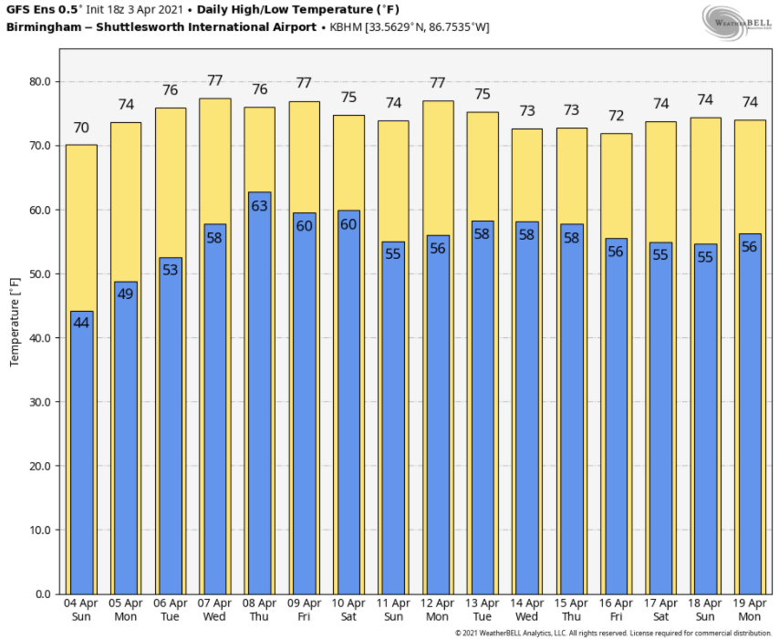
MONDAY/TUESDAY: Two gorgeous days are in store for Alabama to start the workweek. Expect nary a cloud tomorrow, with partly cloudy skies on Tuesday. Highs will be in the middle and upper 70s on both days. Lows will be in the 40s Monday morning and near 50F on Tuesday.
MIDWEEK SYSTEM: Wednesday will be a transition day, with mostly cloudy, breezy, and warm conditions. Highs will be in the upper 70s. A few showers will show up by early evening, with a round of showers and storms along a pre-frontal trough Wednesday night and early Thursday morning. Severe weather doesn’t look likely for Wednesday night, but we will be watching. More rain and storms will occur on Thursday into Thursday evening ahead of the main cold front. It does appear that there might be sufficient instability for strong to severe storms. While low-level helicity does not look like much of a problem, severe storms could occur Thursday afternoon and evening, with damaging winds and hail as the main threats, and a couple of isolated tornadoes a lesser threat. Highs on Thursday will be in the upper 70s.
FOR THE WEEKEND: The rain will move out early Friday morning, giving way to clearing skies. Highs will be in the middle and upper 70s. Saturday and Sunday will feature mostly sunny skies and highs in the middle and upper 70s. Lows will be in the 50s.
VOODOO COUNTRY: Week 2 looks dry across Alabama with a dry cold front passing through on Friday night the 16th. Get used to the 70s for highs and 50s for lows. They will be common over the next two weeks.
BEACHCAST: Gorgeous through Wednesday along the beautiful beaches of Alabama and Northwest Florida. Then there will be a period of wet weather with rain and storms through Saturday. Highs will be in the 70s today and Monday with lower 80s into the weekend. Lows will be in the 50s through Tuesday, with 60s into the weekend.
Click here to see the Beach Forecast Center page.
NATIONALLY: Very quiet nationally with just a couple of red flag warnings in Utah, with wind advisories scattered across the West and northern Plains. There was a flood watch through early this morning across northern Maine, thanks to ice jams Aroostook and St. John Rivers.
WEATHERBAND: The American Meteorological Society has created a club for all of us! The weather enthusiasts of the world! You will connect with weather enthusiasts and experts alike. Special Weather Band items will identify you with the community. You’ll get special discounts on WeatherWise magazine and other merchandise as well as a special newsletter! Join today! https://amsweatherband.org/index.cfm/weatherband/membership/
ADVERTISE WITH US: Deliver your message to a highly engaged audience by advertising on the AlabamaWX.com website. The site enjoyed an amazing 27 MILLION page views in the past 12 months. Don’t miss out! We can customize a creative, flexible, and affordable package that will suit your organization’s needs. Contact me, Bill Murray, at (205) 687-0782, and let’s talk.
WEATHERBRAINS: This week, the panel will entertain Dr. James Fleming. He has written an outstanding book about Joanne Simpson, one of the most amazing women in meteorology. Dr. John Scala, who was a mentee of Dr. Simpson, will join us as well. Check out the show at www.WeatherBrains.com. You can also subscribe on iTunes. You can watch the show live at live.bigbrainsmedia.com or on James’ YouTube Channel You will be able to see the show on the James Spann 24×7 weather channel on cable or directly over the air on the dot 2 feed.
ON THIS DATE IN 1977: It was a terrible day across the South. An F5 tornado touched down just northwest of downtown Birmingham and roared through Smithfield Estates, causing tremendous destruction and death. The tornado blew vehicles off I-65 before lifting near Tarrant. 22 people died along the 15-mile path. At the exact same time, the tornado was wreaking havoc, Southern Airways 242 encountered severe storms over Northwest Georgia. Hail broke the windshield and damaged both engines on the DC-9 causing both to fail. The pilots tried to make it to Dobbins AFB but had to attempt a landing along a highway in New Hope, Georgia. 62 people died on the plane, along with 8 people on the ground. Twenty-one people on the flight survived. Follow my weather history tweets on Twitter. I am @wxhistorian at Twitter.com.
Category: Alabama's Weather, ALL POSTS
About the Author (Author Profile)
Bill Murray is the President of The Weather Factory. He is the site's official weather historian and a weekend forecaster. He also anchors the site's severe weather coverage. Bill Murray is the proud holder of National Weather Association Digital Seal #0001 @wxhistorianSubscribe
If you enjoyed this article, subscribe to receive more just like it.


