A Brief Late Morning Check on Our Severe Weather Threat
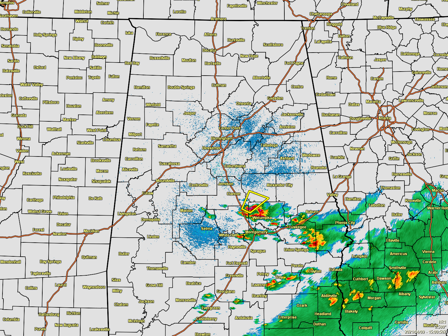
A weak warm front is currently working northward through the south-central parts of Central Alabama where storms are firing up, some of which have become strong to severe with mostly large hail being the main threat, but damaging winds are possible as well.
A Severe Thunderstorm Warning is currently in effect for Coosa and Elmore counties until 10:45 am for the threat of ping pong size hail and gusty winds.
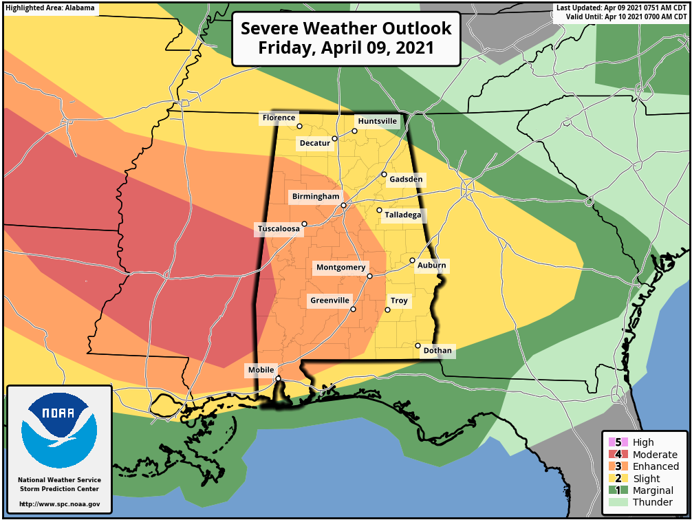
Much of Central Alabama continues under a level 3/5 Enhanced Risk for severe storms through the rest of your Friday and until 7 am Saturday, which includes Hamilton, Birmingham, Hoover, Tuscaloosa, Clanton, Demopolis, Selma, and Montgomery. A Slight Risk covers nearly the rest of North/Central Alabama including Florence, Russellville, Decatur, Athens, Hartselle, Cullman, Huntsville, Guntersville, Scottsboro, Rainsville in North Alabama, and Gadsden, Anniston, Talladega, Alexander City, Auburn, Eufaula, and Troy in Central Alabama. The western half of Sumter County has been included in a level 4/5 Moderate Risk.
The timing for severe weather throughout this first long round will continue from now through at least through 1 am Saturday morning before the second round begins to enter the western parts of the area at or just after 3 am. The Day 1 Severe Weather Outlook continues through 7 am Saturday morning. This first round will consist of mainly scattered storms forming along and behind the warm front as the air quickly destabilizes. Not everyone will see rain with this first round, but rain chances are in the 40-70% range from north to south.
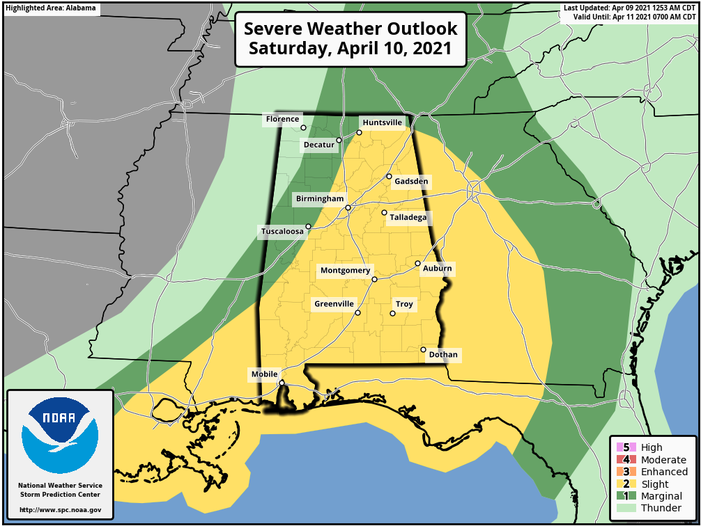
That second round of storms with the potential for severe weather will continue through much of the morning from west to east until the stronger part of the line exits the area by 10 am Saturday. Nearly all of the eastern half of North/Central Alabama, along with the west-central and southwestern parts of the area, will be in a level 2/5 Slight Risk on Saturday. A level 1/5 Marginal Risk is up for just a few miles west of the Slight Risk.
Damaging winds up to 70 MPH and large hail up to quarter size will be the main threats, but a few brief spin-up tornadoes will be possible as well.
Category: Alabama's Weather, ALL POSTS, Severe Weather
About the Author (Author Profile)
Scott Martin is an operational meteorologist, professional graphic artist, musician, husband, and father. Not only is Scott a member of the National Weather Association, but he is also the Central Alabama Chapter of the NWA president. Scott is also the co-founder of Racecast Weather, which provides forecasts for many racing series across the USA. He also supplies forecasts for the BassMaster Elite Series events including the BassMaster Classic.Subscribe
If you enjoyed this article, subscribe to receive more just like it.


