Slight Risk Expanded; Plus, Severe Threat Continues Across Severe T-Storm Watch Area
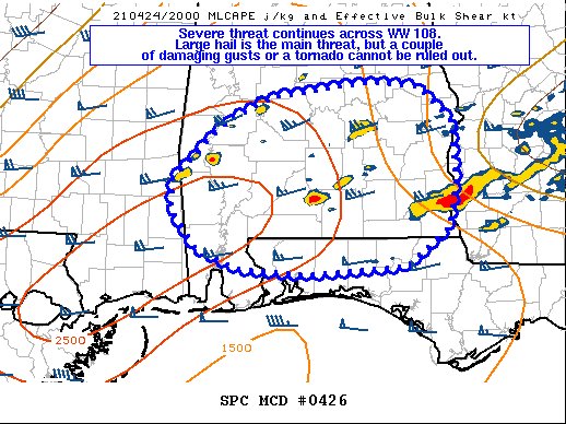
Severe threat continues across the Severe Thunderstorm Watch area. Large hail has become the main threat with any severe storms, but damaging wind gusts or a brief spin-up tornado cannot be ruled out.
Storm coverage has increased across the Severe Thunderstorm Watch area over the past couple of hours, with semi-discrete cellular clusters and a couple of supercells noted across southern AL. MRMS mosaic MESH radar data suggests that over 1.0 inch in diameter hail may be occurring with the more mature supercell structures, particularly in storms with 50+ dBZ echoes exceeding 30 kft. Near 70F dewpoints overspread by adequately steep low and mid-level lapse rates are promoting 1500-2000 J/kg MLCAPE across the area, suggesting that vigorous updrafts may continue to support a primary threat of large hail threat for at least the next few hours. MOB and EOX VWPs depict over 200 m2/s2 0-3 km SRH, but with either small-looping or nearly straight hodographs, suggesting that storm rotation may be relatively confined to the mid-levels. However, transient low-level rotation supporting a couple damaging gusts and perhaps a brief tornado remains possible.
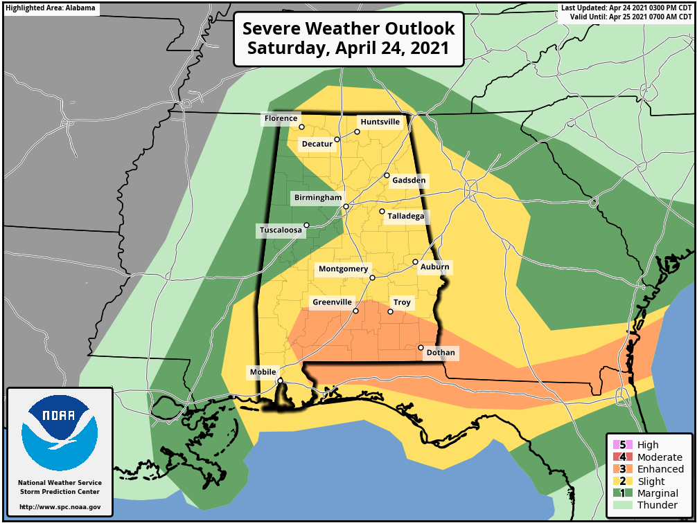
Enhanced Risk continues for the extreme southeastern parts of Central Alabama that includes the cities of Troy Goshen, Spring Hill, Brundidge, Clio, and Blue Springs.
Slight Risk has been expanded across nearly all of North Alabama and most of Central Alabama which now includes Florence, Russellville, Decatur, Athens, Hartselle, Cullman, Huntsville, Scottsboro, Rainsville, Guntersville, Gadsden, Anniston, Birmingham, Talladega, Clanton, Alexander City, Demopolis, Selma, Montgomery, Auburn, and Eufaula.
Marginal Risk continues for the western parts of North/Central Alabama which includes the cities of Waterloo, Red Bay, Hamilton, Tuscaloosa, Livingston, Eutaw, and Centreville.
Category: Alabama's Weather, ALL POSTS, Severe Weather
About the Author (Author Profile)
Scott Martin is an operational meteorologist, professional graphic artist, musician, husband, and father. Not only is Scott a member of the National Weather Association, but he is also the Central Alabama Chapter of the NWA president. Scott is also the co-founder of Racecast Weather, which provides forecasts for many racing series across the USA. He also supplies forecasts for the BassMaster Elite Series events including the BassMaster Classic.Subscribe
If you enjoyed this article, subscribe to receive more just like it.


