Sunday Weather Xtreme Video: Rain and Storms Return
April finished up as a fairly normal month, as Aprils go in Birmingham. The average temperature for the month was 62.1 degrees, slightly below the 62.5F that is average or normal. 4.79 inches of rain fell in the month, slightly above the normal of 4.38 inches. The warmest temperature of the month was 85f this past Wednesday. The coldest was 31F on the 2nd. Thunderstorms occurred on 4 days, pretty close to the normal 5 days. It rained on 7 days, with most of the rainfall falling on 3 days. It usually rains ono 9.1 days in the month.
WELCOME TO MAY: Now we are in the month that features some of the most beautiful weather in Central and North Alabama. The average high and low for the month in Birmingham is 81.5F and 59.7F respectively. At the start of the month, the average high is 78F, but it rises to 85F by the end of the month. Overnight lows really warm, rising from 55F on May 1st to 64F on the 31st. The coldest May reading ever in the Magic City is 36F on May 4, 1971. In May, the warmest reading in May was 99F on May 28, 1962, and May 29, 1898. It generally reaches 90F or warmer 1.9 days in the month. Rain falls on 9.1 days in May and totals 4.99 inches. And thunderstorms occur on 9 days. We will get off to a good start over the next week on those thunderstorm days, rain days, and rainfall.
ON THE WEATHER MAPS THIS MORNING: We find a strong tough in the upper levels of the atmosphere out west, along with one over New England, There is a bit of ridging over Alabama and the Southeast, but there is a strong shortwave trough over Texas. This will be our weathermaker later today and tonight into Monday, with the western trough impacting us after that.
FOR YOUR SUNDAY: Today will be another warm day across Alabama. We’re starting in the mid and upper 50s for the most part. Clouds thickened overnight and are mostly cloudy this morning. A few light showers could be experienced across Central Alabama this morning, but most areas will remain dry. High temperatures across the area will range from 78F to 82F. Rain chances will ramp up this afternoon as a warm front pushes northeast across the area, increasing moisture and instability behind it. Additional showers and storms will move across the Tennessee Valley late tonight and another wave will push northeast across South- and South-Central Alabama tonight. This is just the beginning of a series of disturbances that push rain and storms across Alabama through Tuesday.
SEVERE WEATHER THREAT TONIGHT? Some of the storms over Mississippi could become severe this evening and continue to be severe into West Central Alabama during the overnight hours. Damaging wind and hail will be the main threats.
TOMORROW: Rain and storms will continue in the warm and humid and unstable airmass across Alabama. High will be warm again, in the 80s. There could be a low-end severe weather threat Monday, but it doesn’t look likely.
TUESDAY: There is a better chance of severe weather on Tuesday, it appears as a cold front approaches the area. There will be a marginal risk of severe weather Tuesday afternoon and evening. The threat will again be damaging winds and hail.
REST OF THE WEEK: Rain and storms may hold over into Wednesday. The rest of the week and weekend look dry, although some showers and storms could show back up on Saturday and Sunday. Highs will fall back into the 70s. Lows will be in the 50s.
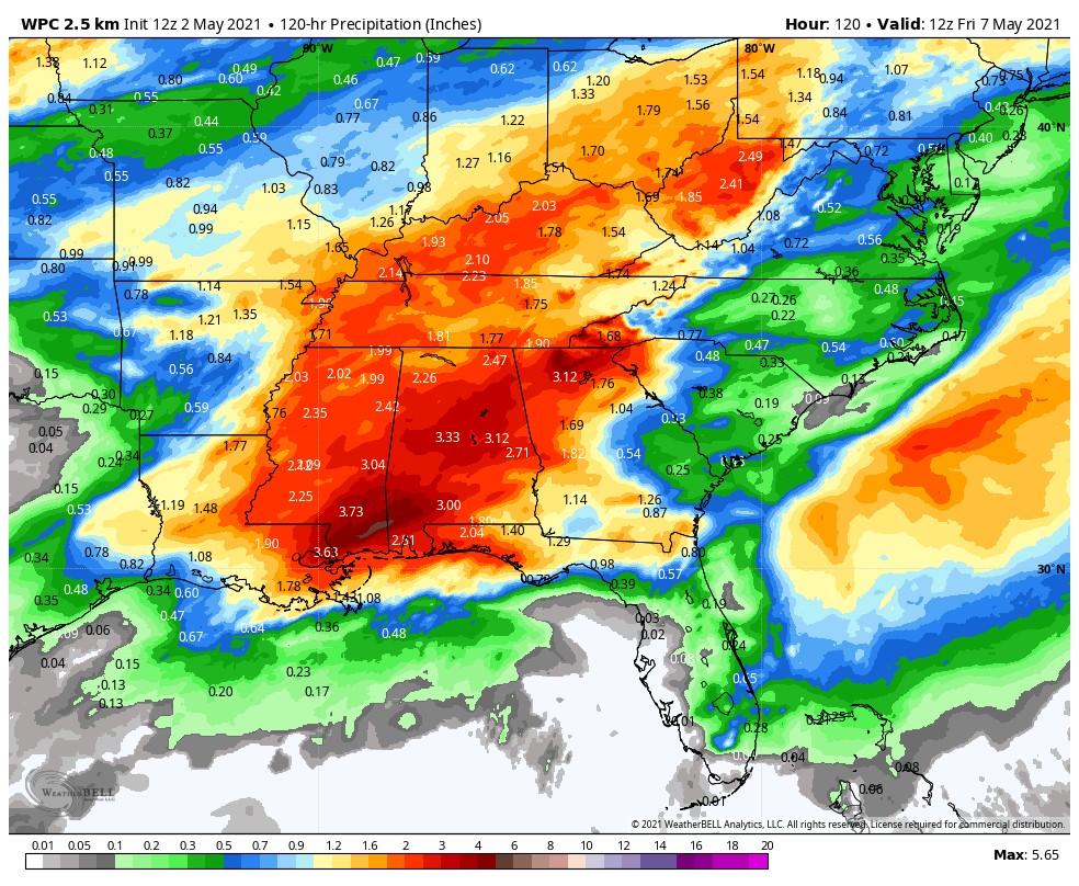
RAINFALL: Rain amounts will be generally between 1 and 3 inches. Rainfall in the second week will be heaviest over the Tennessee Valley. Look for flooding issues over North Alabama and much of Tennessee.
VOODOO COUNTRY: The second week of May looks like it will be active and wet as well. That week will be warm as well, with highs well into the 80s and lows in the 60s.
BEACHCAST: Rain and thunderstorm will be a part of the weather scene most of the week along the beautiful beaches of Alabama and Northwest Florida. Highs will be near 80 degrees. Lows will be in the 60s and lower 70s. It looks like next weekend will much better with no rain, lots of sunshine, highs near 80F, and lows near 60F. Water temperatures will be in the lower 70ss.
Click here to see the Beach Forecast Center page.
DANCING WITH THE STATS: Amazing heat and wind across northern Iowa led to extreme fire conditions. A couple of the record highs included 93F at Mason City and Waterloo. Over thirty record highs were set across the Rockies, Midwest, and Texas on Saturday.
WEATHERBAND: The American Meteorological Society has created a club for all of us! The weather enthusiasts of the world! You will connect with weather enthusiasts and experts alike. Special Weather Band items will identify you with the community. You’ll get special discounts on WeatherWise magazine and other merchandise as well as a special newsletter! Join today! https://amsweatherband.org/index.cfm/weatherband/membership/
ADVERTISE WITH US: Deliver your message to a highly engaged audience by advertising on the AlabamaWX.com website. The site enjoyed over 27 MILLION page views in the past 12 months. Don’t miss out! We can customize a creative, flexible, and affordable package that will suit your organization’s needs. Contact me, Bill Murray, at (205) 687-0782, and let’s talk.
WEATHERBRAINS: This week, the panel will entertain a group of disaster preparedness officials and meteorologists. The subject will be the role of meteorologists in pushing for more disaster-resilient communities. Check out the show at www.WeatherBrains.com. You can also subscribe on iTunes. You can watch the show live at live.bigbrainsmedia.com or on James’ YouTube Channel You will be able to see the show on the James Spann 24×7 weather channel on cable or directly over the air on the dot 2 feed.
ON THIS DATE IN 1982: The Weather Channel wass launched with 4.2 million cable subscribers. Created by network television weathercaster John Coleman, the all-weather network would boast 50 million subscribers by its tenth anniversary. The most popular part of the network’s programming is specific local forecast and warning information, beamed to local cable systems by satellite and displayed on subscribers sets. Follow my weather history tweets on Twitter. I am @wxhistorian at Twitter.com.
Category: Alabama's Weather, ALL POSTS
About the Author (Author Profile)
Bill Murray is the President of The Weather Factory. He is the site's official weather historian and a weekend forecaster. He also anchors the site's severe weather coverage. Bill Murray is the proud holder of National Weather Association Digital Seal #0001 @wxhistorianSubscribe
If you enjoyed this article, subscribe to receive more just like it.


