Flash Flood Threat May Develop Today As Bands of Storms Form
A flash flooding threat may unfold today across North and Central Alabama.
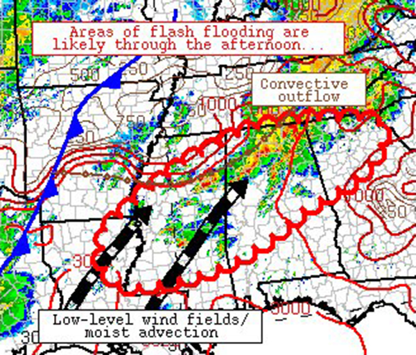
The Weather Prediction Center has issued a Mesoscale Precipitation Discussion outlining their concerns. Bands of heavy thunderstorms ay set up over the parts of North and Central Alabama as well as Mississippi through the afternoon. They could produce training of convention that could lead to 1 to 2 inch per hour rainfall rates and flash flooding. This is in addition to the severe weather threat already in place. A Tornado Watch is in effect for much of Central and Southwest Alabama until 4 p.m.
Mesoscale Precipitation Discussion 0150
NWS Weather Prediction Center College Park MD
1034 AM EDT Tue May 04 2021
Areas affected…eastern Louisiana, Mississippi, northern/central
Alabama, and northern Georgia
Concerning…Heavy rainfall…Flash flooding likely
Valid 041433Z – 042033Z
Summary…At least a couple of bands of flash-flood-producing
convection may materialize across the discussion area through the
afternoon. The most likely areas for this convection area are
across northern Alabama and central/southern Mississippi.
Discussion…Scattered convection was occurring along and ahead of
an extensive convective outflow from eastern Tennessee through
northwestern Alabama and north-central Mississippi. The
convection was in a weakly-capped airmass, with southwesterly,
confluent low-level flow and deep moisture contributing to
sustained and renewed convection from central Mississippi into
northern Alabama. These bands are oriented generally in parallel
with deep-layer shear vectors, allowing for a limited amount of
training and occasional areas of 1-2 inch per hour rainfall rates
at times. This may lead to a localized flash flood threat this
morning.
Later today, ascent associated with a mid-level wave centered over
Oklahoma, an advancing cold front in east Texas, and a
destabilizing airmass across the Lower Mississippi Valley will
support new convective development near western portions of the
discussion area. CAMs indicate that this convection will likely
grow upscale and and foster new MCS development across
Louisiana/Mississippi this afternoon. A couple of axes of
training convection may materialize from this activity – 1) across
northern Alabama, northern Georgia, and northern/central
Mississippi where any upstream, forward-propagating cold pool can
favorably interact with the remnant, stalling outflow boundary in
that area and 2) on the southern flank of the anticipated MCS
where training convection is likely to organize parallel to deep
shear/mean steering flow aloft. Where these bands materialize,
local rainfall rates of 1-3 inches per hour will likely overcome
relatively high flash flood guidance values (especially across
Mississippi – where dry surface conditions will initially sustain
heavy precipitation). Across northern Alabama, flash flooding may
develop more quickly due to current rainfall (and attendant
falling flash flood guidance values). Flash flood guidance is
lower in Georgia where training convection produced heavy rainfall
yesterday morning.
Separate, more spatially focused MPDs may be issued later this
afternoon pending convective trends.
Cook
Category: Alabama's Weather, ALL POSTS, Severe Weather
About the Author (Author Profile)
Bill Murray is the President of The Weather Factory. He is the site's official weather historian and a weekend forecaster. He also anchors the site's severe weather coverage. Bill Murray is the proud holder of National Weather Association Digital Seal #0001 @wxhistorianSubscribe
If you enjoyed this article, subscribe to receive more just like it.


