

Severe T-Storm Watch Likely for the Southeastern Parts of Central Alabama
Here is the text from the latest Mesoscale Discussion from the SPC about the 80% odds of a Severe Thunderstorm Watch being issued for the southeastern parts of Central Alabama:
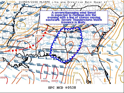
SUMMARY… A severe/damaging wind threat is expected to continue into the evening with a line of storms moving eastward. Severe Thunderstorm Watch issuance is likely.
DISCUSSION… An organized QLCS will move eastward across parts of southern/central AL through the remainder of the afternoon and into the early evening. A moist and unstable airmass exists downstream of this convection, and to the south of an outflow boundary where additional, non-severe storms have formed. As large-scale ascent and 35-40 kt of mid-level flow associated with an upper trough now over the lower MS Valley continues to overspread AL/GA and the FL Panhandle, the QLCS should maintain its intensity through much of the evening. Given the linear nature of this ongoing convection and steep low-level lapse rates owing to diurnal heating, scattered damaging downdraft winds should be the main threat. The low-level flow is not overly strong, and appears mostly veered to southwesterly per recent surface observations and area VWPs. Accordingly, any tornado threat should remain rather brief/isolated. Severe Thunderstorm Watch issuance will likely be needed to address the damaging wind threat.
Category: Alabama's Weather, ALL POSTS, Severe Weather
About the Author (Author Profile)
Scott Martin is an operational meteorologist, professional graphic artist, musician, husband, and father. Not only is Scott a member of the National Weather Association, but he is also the Central Alabama Chapter of the NWA president. Scott is also the co-founder of Racecast Weather, which provides forecasts for many racing series across the USA. He also supplies forecasts for the BassMaster Elite Series events including the BassMaster Classic.Subscribe
If you enjoyed this article, subscribe to receive more just like it.


