Watches, Warning to our West
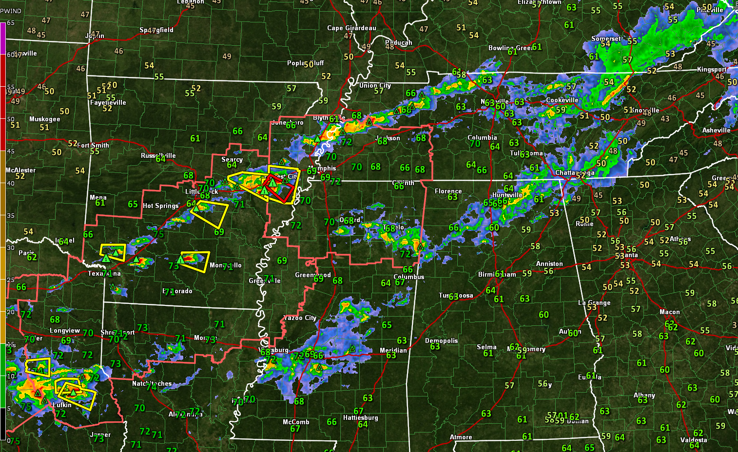
Thunderstorms continue across North and Northwest Alabama at this hour, extending from east of Huntsville to west of Cullman to Carbon Hill. Some quarter-inch hail has been reported in Winston County in the last hour. That’s pea-size. That’s not severe, and neither are the storms right now. The storms have about 500-1,500 joules/kg of CAPE but are dealing with some convective inhibition that is holding them back. They do have decent bulk shear, and even a little bit of low-level shear, so they could produce some isolated severe reports as they move east over the next couple of hours. A weather watch is not anticipated.
TO the west, a severe thunderstorm watch is in effect for northern Mississippi, extreme eastern Arkansas, and southwestern Tennessee. Another one extends across southern Arkansas, western Mississippi, northern Louisiana, and northeastern Texas. A line of storms extends from northwest of Nashville to northwest of Memphis to just north of Texarkana. There are several severe thunderstorm warnings in effect along this line. Some of the best Significant Tornado Parameter values are over southern Arkansas, western Tennessee, and northern Mississipi right now. Appropriately, a tornado warning was just issued for the area around Forrest City, Arkansas.
Ahead of the line, a storm with 2-inch hail is approaching Monticello in Arkansas. The best prospects for large hail right now are over southern Arkansas, where CAPE values are approaching 4,000 j/kg. There are also severe thunderstorms clustered to the northeast of Lufkin, Texas.
Other storms are over Mississippi between Amory, Tupelo, and Oxford. Those storms are growing in density and headed toward Northwest Alabama. They will have modest instability but will be battling that same convective inhibition.
Outside of the watches, storms are occurring over Central Mississippi, from the Jackson area to near Kosciusko. They are not severe but do have some decent instability to work with.
Here in Alabama, dewpoints have come up to near ^)F and above in areas west of I-65. CLouds have definitely increased as moisture levels rise.
Storms could briefly become severe over the next couple of hours, but as we approach 6-7 p.mm., strong should increase markedly intensity over southern Tennessee, northern Mississippi, and northern Alabama. They will push southeast, peaking intensity and then slowly decreasing in intensity as they push southeast. They should reach Birmingham before 10 p.m.
We are monitoring for all severe weather threats tonight in Alabama, with damaging wind and hail posing the biggest threat. There is a small tornado threat over Northwest and North Alabama.
Stay on top of the weather through midnight with good ways to hear any warnings issued for you. We will have frequent updates though the evening and overnight until the severe weather threat is finished.
Category: Alabama's Weather, ALL POSTS, Severe Weather
About the Author (Author Profile)
Bill Murray is the President of The Weather Factory. He is the site's official weather historian and a weekend forecaster. He also anchors the site's severe weather coverage. Bill Murray is the proud holder of National Weather Association Digital Seal #0001 @wxhistorianSubscribe
If you enjoyed this article, subscribe to receive more just like it.


