Hot & Mainly Sunny at Midday; A Few Strong Storms Possible This Afternoon
Just Before Midday
Skies across Central Alabama are mainly clear with the exception of a few fair-weather cumulus clouds over the northern and eastern portions of the area. Nearly the rest of the area has sunny skies. Temperatures as of the 11 am round-up were in the lower 80s to the lower 90s across the area. The hot spot was Troy at 90 degrees. The cool spot was Tuscaloosa at 83 degrees. Birmingham was sitting at 86 degrees.
A Few Strong Storms Possible This Afternoon
During the main heating of the day, we will begin to see scattered showers and thunderstorms develop across the southern two-thirds of Central Alabama, mainly along and south of a line from just north of Reform to Fultondale to Heflin. Main threats will be from isolated damaging thunderstorm wind gusts up to 60 mph and hail up to quarter size in diameter. North of that line, skies should generally remain partly to mostly sunny. Afternoon highs will be in the lower to mid-90s across the area. Those showers and thunderstorms will move southward and eventually out of the area by the evening, but a few may linger along and south of I-85 and US-80 until the late-night hours. Skies will be partly to mostly cloudy with lows in the upper 60s to the lower 70s.
Tropical Update
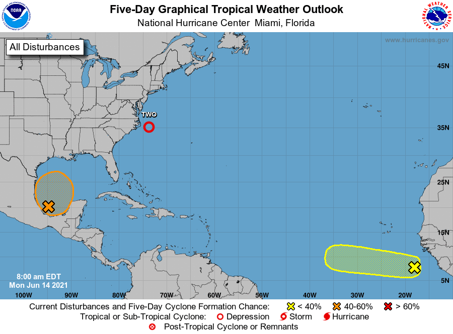
TD-2: At 10 am CDT, the center of Tropical Depression Two was located around 105 miles east of Cape Hatteras, NC. The depression is moving toward the northeast near 21 mph, and this general motion is expected through Wednesday with increasing forward speed. Maximum sustained winds are near 35 mph with higher gusts. The depression is expected to become a tropical storm by tonight and could continue to strengthen on Tuesday. The system should begin to weaken by Tuesday night and is expected to dissipate on Wednesday. The estimated minimum central pressure is 1006 MB (29.71 inches).
INVEST 92L: Showers and thunderstorms located over the Bay of Campeche are associated with a broad low-pressure area. Gradual development of this disturbance is possible during the next couple of days while it meanders near the coast of Mexico, and a tropical depression could form late in the week when the system moves northward into the central Gulf of Mexico. Regardless of development, heavy rainfall is possible over portions of Central America and southern Mexico during the next several days. NHC gives a 60% chance of forming into at least a depression within the next five days.
We also have a strong tropical wave just offshore of West Africa that is producing disorganized shower and thunderstorm activity. Some development of this system is possible during the next few days before a combination of dry air aloft and strong upper-level winds limit any chance of formation while the wave is over the central tropical Atlantic Ocean late week. NHC gives a 20% chance of forming into at least a depression within the next five days.
Category: Alabama's Weather, ALL POSTS, Severe Weather, Tropical
About the Author (Author Profile)
Scott Martin is an operational meteorologist, professional graphic artist, musician, husband, and father. Not only is Scott a member of the National Weather Association, but he is also the Central Alabama Chapter of the NWA president. Scott is also the co-founder of Racecast Weather, which provides forecasts for many racing series across the USA. He also supplies forecasts for the BassMaster Elite Series events including the BassMaster Classic.Subscribe
If you enjoyed this article, subscribe to receive more just like it.


