An Afternoon Look at our PTC #3
Our Potential Tropical Cyclone Three remains disorganized this afternoon but could be very close to becoming Tropical Storm Claudette.
AN Air Force crew was out there since 6 a.m. this morning. They are now flying to Tampa since the system will be affecting their home base of Keesler AFB in Biloxi.
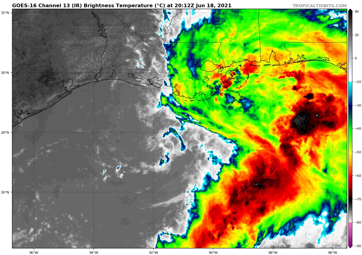
They found a fairly organized low center about 190 miles south-southwest of New Orleans. That seems to line up with some faint echoes with a circular curvature on radar now in the same area.
They found max flight-level winds of about 56 knots in the eastern semicircle, so if the system can form an organized circulation center, it will likely immediately be named Tropical Storm Claudette.
It still has time to do that, but with the system moving north at about 15 mph, the center will be onshore over southern Louisiana south of Houma late tonight between 9 pm and midnight.
Another plane will be departing for the storm in the next couple of hours.
The system is a big asymmetrical mess with lots of thunderstorms on the eastern side, and a good supply of dry air on the western side.
Heavy rain bands are on the southeastern Louisiana coast now, with some outer bands on the Mississippi and Alabama coasts now.
Winds are gusting to 34 mph at Gulfport now.
Heavy rain and flooding will be an issue through the overnight hours over southeastern Louisiana, southern Mississippi, southern Alabama, and Northwest Florida. This heavy rain will spread up into Central Alabama early on Saturday.
The center is expected to cross Central Alabama late on Saturday night into early Sunday. Heavy rain and storms will affect Central Alabama into the early morning hours on Sunday.
Tornadoes will be a threat later this afternoon and tonight from Southeast Louisiana to the Florida Panhandle, and up into South Alabama on Saturday. The greatest threat appears that it will be south of a line from Linden to Clanton to Roanoke.
Flash flood watches are in effect for all of South Alabama and much of Central Alabama through Sunday.
Along the beaches, rip currents are a big risk and double red flags are flying all along the beautiful beaches of Alabama and Northwest Florida.
New advisory coming up at 4 p.m. We will continue to have the latest throughout the weekend.
Category: Alabama's Weather, ALL POSTS, Tropical
About the Author (Author Profile)
Bill Murray is the President of The Weather Factory. He is the site's official weather historian and a weekend forecaster. He also anchors the site's severe weather coverage. Bill Murray is the proud holder of National Weather Association Digital Seal #0001 @wxhistorianSubscribe
If you enjoyed this article, subscribe to receive more just like it.


