Tropical Storm Claudette Has Formed Just Southwest of New Orleans After Moving Onshore
SUMMARY OF 400 AM CDT…0900 UTC…INFORMATION
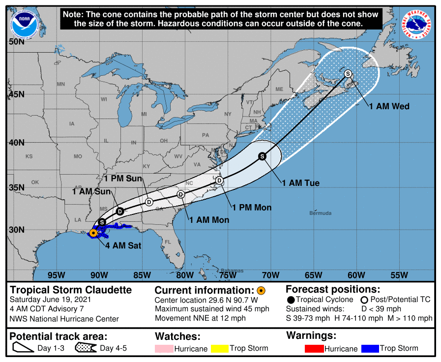
LOCATION…29.6N 90.7W
ABOUT 45 MI…75 KM SW OF NEW ORLEANS LOUISIANA
ABOUT 175 MI…280 KM WSW OF MOBILE ALABAMA
MAXIMUM SUSTAINED WINDS…45 MPH…75 KM/H
PRESENT MOVEMENT…NNE OR 15 DEGREES AT 12 MPH…19 KM/H
MINIMUM CENTRAL PRESSURE…1006 MB…29.71 INCHES
SUMMARY OF WATCHES AND WARNINGS IN EFFECT
A Tropical Storm Warning is in effect for…
* East of Morgan City, Louisiana to the Okaloosa/Walton County line Florida.
* Lake Pontchartrain, Lake Maurepas, and Metropolitan New Orleans
DISCUSSION AND OUTLOOK
At 400 AM CDT (0900 UTC), the center of Tropical Storm Claudette was located inland near latitude 29.6 North, longitude 90.7 West. Claudette is moving toward the north-northeast near 12 mph (19 km/h). A turn toward the northeast is expected later today, with a turn toward the east-northeast expected by tonight or Sunday. On the forecast track, the system should move farther inland over Louisiana during the next several hours, then move across portions of the Gulf Coast and southeastern states through the weekend, and over the western Atlantic Ocean on Monday.
Maximum sustained winds remain near 45 mph (75 km/h) with higher gusts. Claudette is expected to weaken to a tropical depression by tonight and become a post-tropical cyclone on Sunday. The system is forecast to re-develop over the western Atlantic Ocean on Monday.
Tropical-storm-force winds extend outward up to 205 miles (335 km) from the center. The estimated minimum central pressure is 1006 mb (29.71 inches).
HAZARDS AFFECTING LAND
RAINFALL: Claudette is expected to produce rainfall totals of 5 to 10 inches with isolated maximum amounts of 15 inches across portions of the central Gulf Coast. Life-threatening flash flooding impacts are possible across coastal Mississippi and Alabama, and the far western Florida Panhandle through the afternoon. Considerable flash, urban and small stream flooding impacts as well as new and renewed minor to isolated moderate river flooding are likely across the remainder of the Central Gulf Coast.
As the system continues to lift northeast through the weekend, heavy rain will expand across central Alabama, central and northern Georgia, into the Piedmont of the Carolinas, resulting in rainfall totals of 3 to 6 inches with isolated maximum amounts of 8 inches. Flash, urban, small stream and isolated minor river flooding impacts are possible.
STORM SURGE: The combination of storm surge and the tide will cause normally dry areas near the coast to be flooded by rising waters moving inland from the shoreline. The water could reach the following heights above ground somewhere in the indicated areas if the peak surge occurs at the time of high tide…
Morgan City, LA to Okaloosa/Walton County Line, FL…2-3 ft
Lake Borgne and Mobile Bay…2-3 ft
Lake Pontchartrain and Lake Maurepas…1-2 ft
Okaloosa/Walton County Line, FL to Panama City, FL…1-2 ft
Pensacola Bay, Choctawhatchee Bay, and Saint Andrew Bay…1-2 ft
Cameron, LA to Morgan City, LA…1-2 ft
Vermilion Bay…1-2 ft
Surge-related flooding depends on the relative timing of the surge and the tidal cycle, and can vary greatly over short distances. For information specific to your area, please see products issued by your local National Weather Service forecast office.
WIND: Tropical storm conditions should continue along the coast in the warning area today.
TORNADOES: A few tornadoes are possible today and tonight across southern Mississippi, southern Alabama, the western Florida Panhandle, and southwest Georgia.
Category: Alabama's Weather, ALL POSTS, Severe Weather, Tropical
About the Author (Author Profile)
Scott Martin is an operational meteorologist, professional graphic artist, musician, husband, and father. Not only is Scott a member of the National Weather Association, but he is also the Central Alabama Chapter of the NWA president. Scott is also the co-founder of Racecast Weather, which provides forecasts for many racing series across the USA. He also supplies forecasts for the BassMaster Elite Series events including the BassMaster Classic.Subscribe
If you enjoyed this article, subscribe to receive more just like it.


