Here’s a Look at Alabama’s Weather at 11:15 a.m.
I love this set of images of Tropical Storm Claudette:
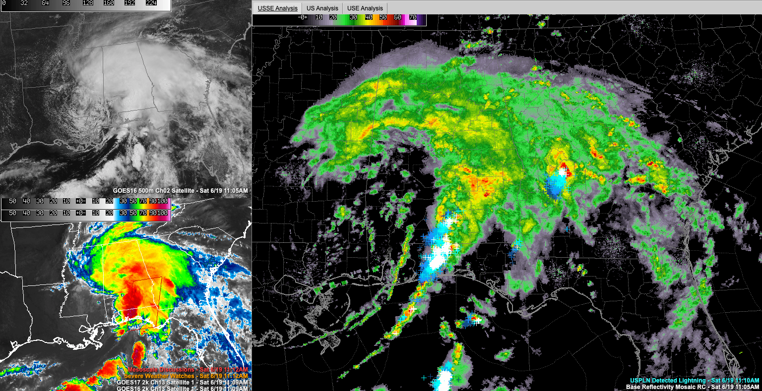
The upper left shows Claudette from a visible satellite perspective. The lower left shows the infrared satellite showing the cold cloud tops. And the main image is a radar composite with lightning superimposed on it.
The center of Tropical Storm Claudette is near Hattiesburg, Mississippi at this hour.
There are a few gusts to tropical storm force occurring ahead of the main squall line now which extends from west of Brewton to west of Pensacola at this hour. Winds gusted to 43 mph at the Pensacola Regional Airport and 40 mph at the Pensacola Naval Air Station within the hour. A severe thunderstorm warning is in effect for areas east of Pensacola ahead of that fedder band.
Winds are calmer in the dry slow with has worked across southeastern Mississippi and Southwest Alabama as far north as Greene and Perry Counties in our state. Winds are averaging 6-12 moh with an occasional gust to 15-20 mph. Winds are not expected to be a problem in our part of the state.
Very heavy rain is falling to the northeast of the center and in the feeder bands over South Alabama and Northwest Florida. Many roads are flooded and closed in Brewton with swift currents in the flooding. Flooding is reported over Main Street in Atmore right now.
Steady rain now covers much of Central Alabama south of US-278. The heaviest rain extends from Aliceville to Tuscaloosa to Helena to Clanton. This will lift northeast across the Birmingham Metro aoover the next hour with some gusty winds as well. There is no lightning over Central Alabama.
It looks like Central Alabama rainfall amounts will be right around an inch, so flooding issues are not expected in this part of the state.
A tornado threat continues over South Alabama with a tornado watch in effect until 7 p.m. for South and Southeast Alabama. Central Alabama counties include Barbour, Bullock, Lee, Lowndes, Macon, Montgomery, Pike, and Russell. There are no tornado warnings currently in Alabama or Northwest Florida.
The storm surge peaked last night at 5.4 feet above normal in Waveland MS last night just before 3 a.m.
Category: Alabama's Weather, ALL POSTS, Tropical
About the Author (Author Profile)
Bill Murray is the President of The Weather Factory. He is the site's official weather historian and a weekend forecaster. He also anchors the site's severe weather coverage. Bill Murray is the proud holder of National Weather Association Digital Seal #0001 @wxhistorianSubscribe
If you enjoyed this article, subscribe to receive more just like it.


