At 10 pm: Center of Claudette Moving Through Central Alabama
SUMMARY OF 1000 PM CDT…0300 UTC…INFORMATION
———————————————–
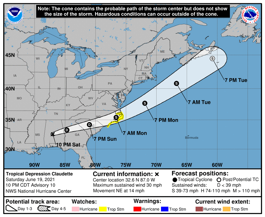
LOCATION…32.6N 87.0W
ABOUT 45 MI…75 KM WNW OF MONTGOMERY ALABAMA
ABOUT 120 MI…195 KM W OF COLUMBUS GEORGIA
MAXIMUM SUSTAINED WINDS…30 MPH…45 KM/H
PRESENT MOVEMENT…NE OR 50 DEGREES AT 14 MPH…22 KM/H
MINIMUM CENTRAL PRESSURE…1005 MB…29.68 INCHES
WATCHES AND WARNINGS
——————–
CHANGES WITH THIS ADVISORY:
None.
SUMMARY OF WATCHES AND WARNINGS IN EFFECT:
A Tropical Storm Watch is in effect for…
* Cape Fear to Duck, North Carolina
* Pamlico and Albemarle Sounds
A Tropical Storm Watch means that tropical storm conditions are
possible within the watch area, in this case within the next 36 to
48 hours.
Interests elsewhere across the southeast U.S. should monitor the
progress of this system. Tropical storm warnings will likely be
required for a portion of the watch area Sunday morning.
For storm information specific to your area, including possible
inland watches and warnings, please monitor products issued by your
local National Weather Service forecast office.
DISCUSSION AND OUTLOOK
———————-
At 1000 PM CDT (0300 UTC), the center of Tropical Depression
Claudette was located near latitude 32.6 North, longitude 87.0 West.
The depression is moving toward the northeast near 14 mph (22 km/h).
A turn toward the east-northeast is expected tonight and Sunday.
On the forecast track, the system should cross portions of the
southeast U.S. through Sunday night, and move over the coasts of
the Carolinas into the western Atlantic Ocean on Monday.
Maximum sustained winds are now near 30 mph (45 km/h) with higher
gusts. These winds are mainly occurring over the Gulf of Mexico
well to the south of the center. Little change in strength is
expected tonight and Sunday. However, the cyclone is forecast to
become a tropical storm again when it moves across the Carolinas
Sunday night or early Monday.
The estimated minimum central pressure based on surface
observations is 1005 mb (29.68 inches).
HAZARDS AFFECTING LAND
———————-
Key messages for Claudette can be found in the Tropical Cyclone
Discussion under AWIPS header MIATCDAT3, WMO header WTNT43 KNHC,
and on the web at
www.hurricanes.gov/graphics_at3.shtml?key_messages.
RAINFALL: Claudette is expected to produce additional rainfall
totals of 2 to 4 inches with isolated maximum amounts of 8 inches
across northern Alabama, northern Georgia, the Florida Panhandle,
and South and North Carolina. Flash, urban and small stream flooding
impacts, as well as new and renewed minor to isolated moderate river
flooding are possible across these areas.
Storm total rainfall is expected to be 5 to 10 inches with isolated
15 inch totals in southeast Louisiana, southern Mississippi,
southern Alabama, and the western Florida panhandle.
For the latest rainfall reports and wind gusts associated with
Claudette, see the companion storm summary at WBCSCCNS3 with the
WMO header ACUS43 KWBC or at the following link:
https://www.wpc.ncep.noaa.gov/discussions/nfdscc3.html
STORM SURGE: The combination of storm surge and the tide will
cause normally dry areas near the coast to be flooded by rising
waters moving inland from the shoreline. The water could reach the
following heights above ground somewhere in the indicated areas if
the peak surge occurs at the time of high tide…
Cape Lookout, NC to NC/VA Border…1-3 ft
Surge-related flooding depends on the relative timing of the surge
and the tidal cycle, and can vary greatly over short distances. For
information specific to your area, please see products issued by
your local National Weather Service forecast office.
WIND: Tropical storm conditions are possible in the watch area
Sunday night and Monday.
TORNADOES: A few tornadoes are possible tonight across southeast
Alabama, the Florida Panhandle and southern Georgia, and across
parts of Georgia and the Carolinas on Sunday.
Category: Alabama's Weather, ALL POSTS, Severe Weather, Tropical
About the Author (Author Profile)
Scott Martin is an operational meteorologist, professional graphic artist, musician, husband, and father. Not only is Scott a member of the National Weather Association, but he is also the Central Alabama Chapter of the NWA president. Scott is also the co-founder of Racecast Weather, which provides forecasts for many racing series across the USA. He also supplies forecasts for the BassMaster Elite Series events including the BassMaster Classic.Subscribe
If you enjoyed this article, subscribe to receive more just like it.


