Tuesday Weather Xtreme: Front Pushes South of the Area Today
Showers and thunderstorms pushed southward across Alabama during the late-night and early morning hours ahead of a cold front. The severe weather threat diminished as the night wore on. but the showers and storms rumbled on, dumping heavy rain and making a ruckus with their loud thunder. Most of the storms will be south of I-20 by 8 a.m. The storms will mostly dissipate during the morning, but they may rejuvenate a bit as they exploit the heat of the day over South and Southeast Alabama later today. Those storms could become severe, with damaging winds again the main threat.
SLOW CLEARING TODAY: But for most of North and Central Alabama, the story will be one of slow clearing from the west. High temperatures will be in the 70s north to near 80 in the I-20 Corridor with lower 80s over South Central Alabama. Much drier air will be working in during the afternoon, and dewpoints will fall into the lower 60s tonight. Not crisp by any description, but better than the middle 70s we have been enduring. Lows tonight will drop into the lower 60s!! Some of the normally colder locations will see upper 50s tonight.
MID TO LATE WEEK: It looks like the northern half of Alabama will remain dry Wednesday. A few showers or storms could return to Central Alabama on Thursday and Friday as the Ring of Fire sets up over Alabama on the periphery of the subtropical high to our east. Highs will be in the middle 79s, Lows will edge back toward 70F.
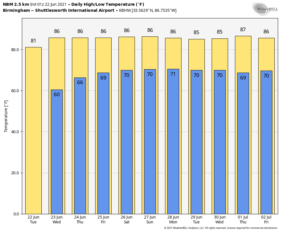
WEEKEND OUTLOOK: Showers and storm chances look better for the weekend, but no washout for sure. Fairly typical summertime weather for Saturday with scattered showers and storms. Rain chances will increase on Sunday and into Monday as another front tries to work its way into our area. Highs will trend back to the lower 80s. Lows will stubbornly hang around the 70-degree mark.
BYE CLAUDETTE: I wished Claudette goodbye on Sunday, but it turned out that was premature. No, she isn’t coming back to Alabama. And we are going to push some of her humidity out of here with the help of our current front. But pick a fork in it, Claudette ceased being a tropical system last evening. Claudette weakened into an open wave and dissipated as a tropical cyclone. Good riddance, I say.
TROPICS: A tropical wave several hundreds of miles east southeast of the Windward Islands has been looking pretty healthy. It could get even a little more organized over the next couple of days before conditions become unfavorable for tropical development on Thursday. So it doesn’t appear this system has much of a chance to become a tropical cyclone, at least until…
VOODOOLAND: This system will find a much more development-friendly environment by the time it gets to the western Caribbean next week (aka Voodooland). In fact, the GFS has been showing the audacity to spin up a tropical cyclone over the southwestern Gulf of Mexico by next Wednesday. The noon run yesterday showed a minimal hurricane moving up into the Florida Big Bend area by July 1. So it’s not a forecast for sure. But will be interesting to watch.
BEACHCAST: Messy along the beautiful beaches of Alabama and Northwest Florida. In fact it will be a loud morning today with lots of heavy rain and thunder. Rain and storms stay in the forecast much of the week with the frontal system trying to horn in on the great seafood and white sandy beaches. Look for improving conditions by weekend. Typical summer temps with highs in the upper 80s, lows in the upper 70s, and water temperatures in the lower to middle 80s. Rip corrects will be an issue as well.
Click here to see the Beach Forecast Center page.
WEATHERBRAINS: This week’s show is in the can already with James’ imminent vacation. We visited with Storm Chaser Aaron Rigsby on the show, which will be released this morning on the normal channels. Check out the show at www.WeatherBrains.com. You can also subscribe on iTunes. You can watch the show live at live.bigbrainsmedia.com or on James’ YouTube Channel You will be able to see the show on the James Spann 24×7 weather channel on cable or directly over the air on the dot 2 feed.
ON THIS DATE IN 1928: Mr. Will Keller of Greensburg, KS had the unique experience of looking straight up into a tornado as it passed over his storm cellar. Familiar with tornadoes, Keller was closely observing an umbrella-shaped cloud to the southwest of his farmstead. As the storm approached, he noted three tornadoes hanging from the storm base. He hurried his family into their storm shelter. He says that he was just about the close the door when he decided to take a last look at the storm. One of the funnel clouds rose slightly as it approached his position. As it went directly overhead he was able to look up into the inside of the funnel cloud. Underneath the funnel, he said that the air was very still with a strong gassy odor and a loud hissing sound. They said the inside of the funnel was illumined by constant lightning flashes. He observed small tornadoes rotating around the inside of the larger funnel. An amazing experience. Follow my weather history tweets on Twitter. I am @wxhistorian at Twitter.com.
Category: Alabama's Weather, ALL POSTS
About the Author (Author Profile)
Bill Murray is the President of The Weather Factory. He is the site's official weather historian and a weekend forecaster. He also anchors the site's severe weather coverage. Bill Murray is the proud holder of National Weather Association Digital Seal #0001 @wxhistorianSubscribe
If you enjoyed this article, subscribe to receive more just like it.


