Tropical Storm Watch Issued for Parts of Haiti Ahead of Elsa’s Arrival
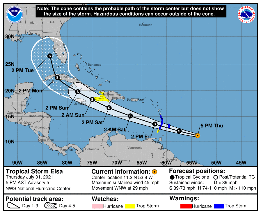
SUMMARY OF 500 PM AST…2100 UTC…INFORMATION
LOCATION…11.2N 53.8W
ABOUT 410 MI…660 KM ESE OF BARBADOS
ABOUT 520 MI…835 KM ESE OF ST. VINCENT
MAXIMUM SUSTAINED WINDS…45 MPH…75 KM/H
PRESENT MOVEMENT…WNW OR 285 DEGREES AT 29 MPH…46 KM/H
MINIMUM CENTRAL PRESSURE…1005 MB…29.68 INCHES
SUMMARY OF WATCHES AND WARNINGS IN EFFECT
A Tropical Storm Warning is in effect for…
* Barbados
* Martinique
* St. Lucia
* St. Vincent and the Grenadines
A Tropical Storm Watch is in effect for…
* Grenada and its dependencies
* The southern and western coasts of Haiti from the southern border
of the Dominican Republic to Le Mole le St. Nicholas
Interests elsewhere in the Windward Islands, Leeward Islands, the Virgin Islands, Puerto Rico, the Dominican Republic, Haiti, eastern Cuba, and Jamaica should monitor the progress of Elsa. Additional watches and warnings will likely be required later tonight and Friday.
FORECAST DISCUSSION
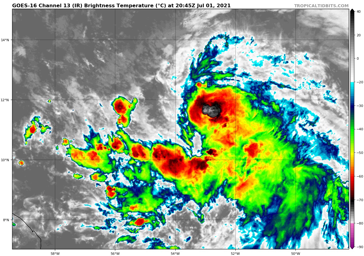
The structure of Elsa has changed little since the last advisory, with the low-level center partly exposed to the northwest of the somewhat-ragged primary convective band. Various subjective and objective satellite intensity estimates have changed little during the last 6 h, so the initial intensity is held at 40 kt.
The initial motion is now 285/25. There is little change to the track forecast philosophy from the previous advisory. A rapid west-northwestward motion is likely for the next 48 h or so as Elsa is steered by the strong subtropical ridge to the north. After that time, the storm is expected to approach a weakness in the ridge caused by a mid-latitude trough over the eastern United States. The guidance becomes rather divergent as this happens, as the ECWMF and the ECMWF ensembles forecast a turn toward the north while the GFS and UKMET are forecasting a continued west-northwestward to northwestward motion. In addition, the GFS ensemble members are spread from a continued west-northwestward motion toward the Yucatán Peninsula on one side to a northward motion east of the northern Bahamas on the other. The latter part of the new NHC forecast track will still lean more toward the deterministic GFS/UKMET solutions, but the confidence remains low. The new official forecast track again has only minor adjustments from the previous forecast.
The intensity forecast and its high uncertainty are also little changed from the last advisory. Some strengthening is expected during the next day or so as Elsa is expected to be in an environment of warm sea-surface temperatures, light vertical wind shear, and high mid-level relative humidity. However, as mentioned earlier, the fast forward motion could result in the upper and lower parts of the storm being unable to stay together, and this could limit strengthening. The latter part of the intensity forecast also has the issues of possible land interaction and disagreements among the global models on how favorable the upper-level winds will be, although the latest model runs trended toward less favorable conditions north of about 22N. This uncertainty is highlighted by the UKMET forecasting Elsa to weaken to a trough near western Cuba, while the GFS forecasts it to be a hurricane in the same area and time. Based on these factors, the NHC intensity forecast continues to be on the lower end of the intensity guidance suite.
KEY MESSAGES
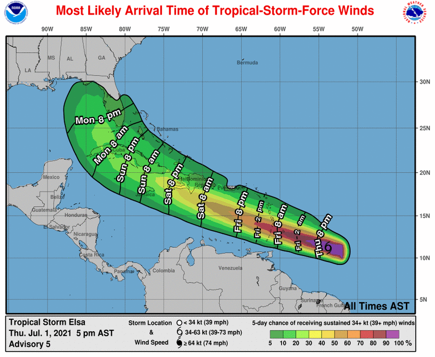
1. Tropical storm conditions are expected beginning early Friday in portions of the Windward and southern Leeward Islands, and are possible over portions of southern Hispaniola on Saturday.
2. Heavy rainfall from Elsa will move quickly across the Windward and southern Leeward Islands, including Barbados, on Friday. Outer rain bands will impact Puerto Rico on Friday and southern Hispaniola by early Saturday. Flooding and mudslides are possible.
3. There is a risk of wind and rainfall impacts in portions of Cuba, Jamaica, the Turks and Caicos, and the Bahamas through early next week. Interests in these areas should monitor Elsa’s progress and updates to the forecast.
4. There is a risk of storm surge, wind, and rainfall impacts in the Florida Keys and portions of the Florida Peninsula early next week. However, the forecast uncertainty remains larger than usual due to Elsa’s potential interaction with the Greater Antilles this weekend. Interests in Florida should monitor Elsa’s progress and updates to the forecast.
About the Author (Author Profile)
Scott Martin is an operational meteorologist, professional graphic artist, musician, husband, and father. Not only is Scott a member of the National Weather Association, but he is also the Central Alabama Chapter of the NWA president. Scott is also the co-founder of Racecast Weather, which provides forecasts for many racing series across the USA. He also supplies forecasts for the BassMaster Elite Series events including the BassMaster Classic.Subscribe
If you enjoyed this article, subscribe to receive more just like it.


