Hurricane Elsa Passing Near to St. Vincent & St. Lucia

SUMMARY OF 1100 AM AST…1500 UTC…INFORMATION
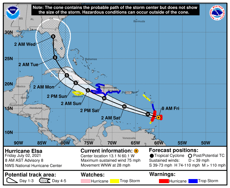
LOCATION…13.4N 61.2W
ABOUT 5 MI…10 KM N OF ST. VINCENT
ABOUT 675 MI…1090 KM ESE OF SANTO DOMINGO DOMINICAN REPUBLIC
MAXIMUM SUSTAINED WINDS…75 MPH…120 KM/H
PRESENT MOVEMENT…WNW OR 290 DEGREES AT 29 MPH…46 KM/H
MINIMUM CENTRAL PRESSURE…995 MB…29.39 INCHES
SUMMARY OF WATCHES AND WARNINGS IN EFFECT
A Hurricane Warning is in effect for…
* St. Lucia
* St. Vincent and the Grenadines
* Southern portion of Haiti from Port Au Prince to the southern border with the Dominican Republic
A Tropical Storm Warning is in effect for…
* Barbados
* Martinique
* Dominica
* The southern coast of Dominican Republic from Cabo Engano to the border with Haiti
* The coast of Haiti north of Port Au Prince
* Jamaica
A Hurricane Watch is in effect for…
* South coast of the Dominican Republic from Punta Palenque to the border with Haiti
* Jamaica
A Tropical Storm Watch is in effect for…
* Grenada and its dependencies
* Saba and Sint Eustatius
* North coast of the Dominican Republic from Cabo Engano to Bahia de Manzanillo
Interests elsewhere in the Windward Islands, Leeward Islands, the Virgin Islands, Puerto Rico, the Dominican Republic, Cuba, and the Cayman Islands should monitor the progress of Elsa. Additional watches and warnings will likely be required later today.
FORECAST DISCUSSION
Satellite imagery indicates that Elsa has become better organized, and radar data from Barbados and Martinique have shown attempts at eye formation. The formative northern eyewall passed over Barbados near 11-12Z, and hurricane-force winds were reported there at that time. The initial intensity is set at 65 kt based on those data. It should be noted that reports from an Air Force Reserve Hurricane Hunter aircraft suggest that the circulation is not well-developed at 700 mb, possible due to the rapid forward speed.
The initial motion is 290/25. There is little change to the forecast track or the forecast guidance since the last advisory. The guidance is in good agreement on a rapid west-northwestward notion to near the south coast of the Dominican Republic by 36 hr. After that, the general consensus is that Elsa should turn northward by 96 h through a weakness in the subtropical ridge created by a mid-latitude trough. However, the guidance is quite divergent around this consensus, with possible tracks ranging from a west-northwestward motion through the Yucatan Channel or western Cuba to a northward motion through the Bahamas. Thus, the latter portion of the track forecast remains low confidence.
The intensity forecast calls for a little more strengthening during the next 36 h as Elsa moves through an environment of light westerly shear. After that, land interaction, along with less favorable upper-level winds over the Gulf of Mexico, is likely to cause weakening. The new NHC intensity forecast shows major adjustments from the previous forecasts based primarily on the initial intensity.
It should be noted that the average NHC track errors are 175 miles and 200 miles at days 4 and 5, respectively. Given the larger-than-normal uncertainty and because hazards will extend well away from the center of the storm, users are urged to not focus on the exact forecast points.
KEY MESSAGES
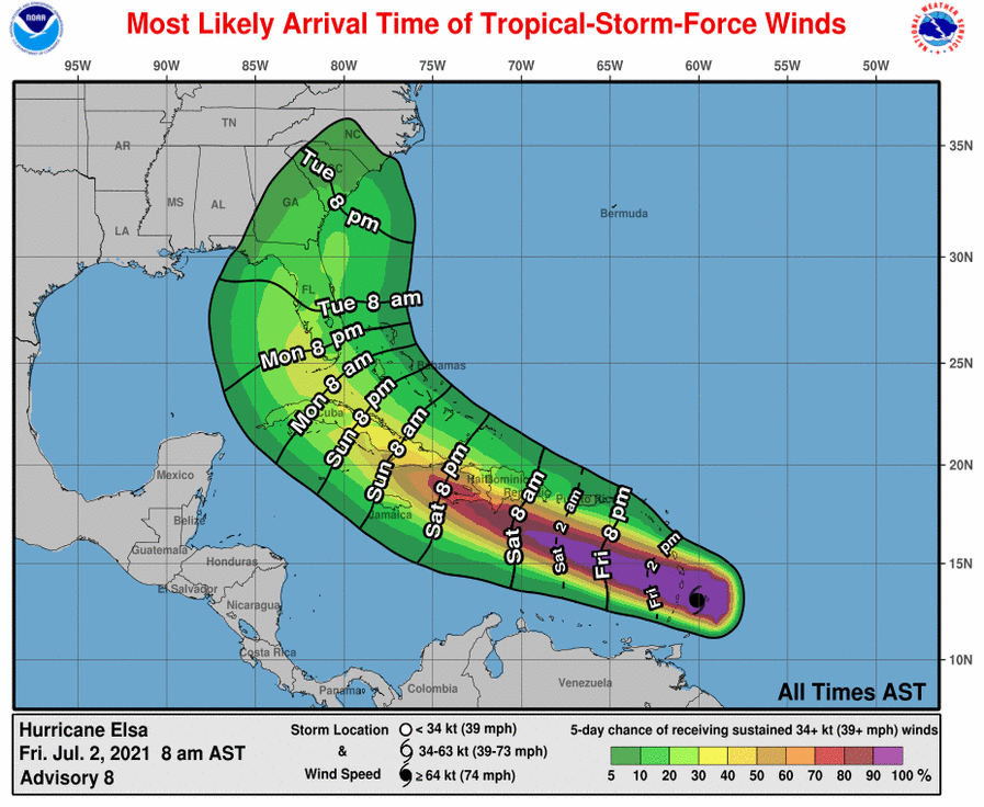
1. Hurricane conditions are expected in the Hurricane Warning area in the Windward Islands for the next few hours. Tropical storm conditions are expected in other portions of the Windward and Leeward Islands. Hurricane conditions are expected in the Hurricane Warning area in Haiti on Saturday. Tropical storm conditions are expected, with hurricane conditions possible along the southern coast of the Dominican Republic and in Jamaica.
2. Heavy rainfall from Elsa will move quickly across the Windward and southern Leeward Islands today, including Barbados. Outer rain bands will impact Puerto Rico late today into Saturday, and southern Hispaniola and Jamaica Saturday into Sunday. Flooding and mudslides are possible.
3. There is an increasing risk of strong winds, storm surge and rainfall impacts in portions of Cuba this weekend and early next week, with impacts also possible in the Turks and Caicos and the Bahamas. Interests in these areas should monitor Elsa’s progress and updates to the forecast.
4. There is a risk of storm surge, wind, and rainfall impacts in the Florida Keys and portions of the Florida Peninsula early next week. However, the forecast uncertainty remains larger than usual due to Elsa’s potential interaction with the Greater Antilles this weekend. Interests in Florida should monitor Elsa’s progress and updates to the forecast.
Category: ALL POSTS, Severe Weather, Tropical
About the Author (Author Profile)
Scott Martin is an operational meteorologist, professional graphic artist, musician, husband, and father. Not only is Scott a member of the National Weather Association, but he is also the Central Alabama Chapter of the NWA president. Scott is also the co-founder of Racecast Weather, which provides forecasts for many racing series across the USA. He also supplies forecasts for the BassMaster Elite Series events including the BassMaster Classic.Subscribe
If you enjoyed this article, subscribe to receive more just like it.


