

4 pm Update: Tropical Storm Watches Issued for Cuba & The Florida Keys Ahead of Elsa’s Arrival
SUMMARY OF 4 PM CDT…2100 UTC…INFORMATION
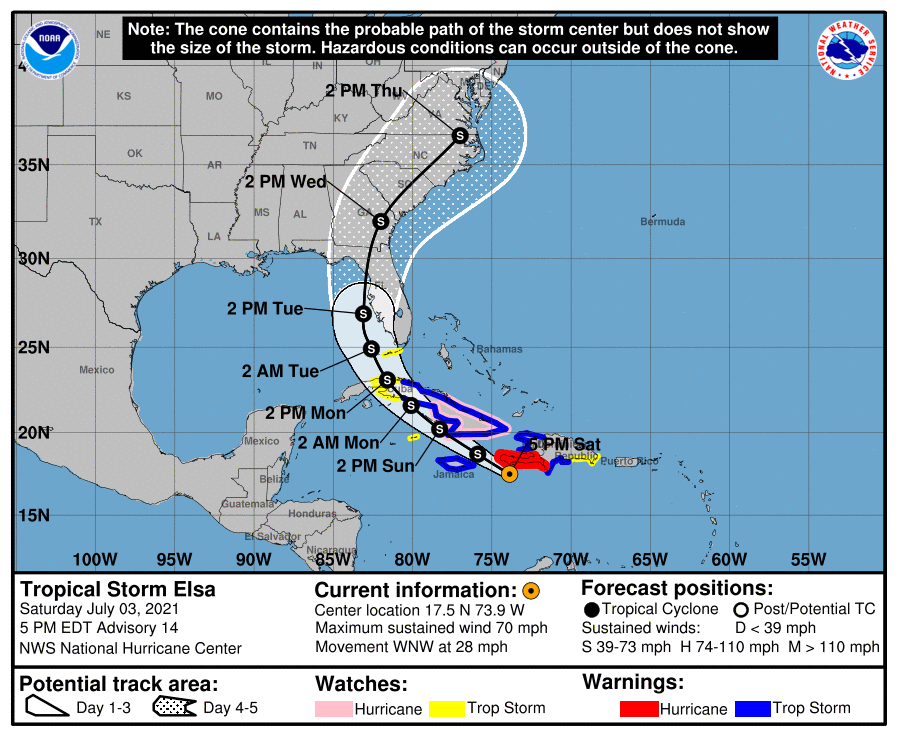
LOCATION…17.5N 73.9W
ABOUT 130 MI…210 KM SW OF PORT AU PRINCE HAITI
ABOUT 195 MI…310 KM E OF KINGSTON JAMAICA
MAXIMUM SUSTAINED WINDS…70 MPH…110 KM/H
PRESENT MOVEMENT…WNW OR 290 DEGREES AT 28 MPH…44 KM/H
MINIMUM CENTRAL PRESSURE…1000 MB…29.53 INCHES
WATCHES AND WARNINGS
A Hurricane Warning is in effect for…
* Southern portion of Haiti from Port Au Prince to the southern border with the Dominican Republic.
A Tropical Storm Warning is in effect for…
* The coast of Haiti north of Port Au Prince
* Southern coast of Dominican Republic from Punta Palenque to the border with Haiti
* The Cuban provinces of Camaguey, Granma, Guantanamo, Holguin, Las Tunas, Santiago de Cuba, Ciego de Avila, Sancti Spiritus, Villa Clara, and Cienfuegos
* Jamaica
A Hurricane Watch is in effect for…
* The Cuban provinces of Camaguey, Granma, Guantanamo, Holguin, Las Tunas, and Santiago de Cuba
A Tropical Storm Watch is in effect for…
* South coast of the Dominican Republic east of Punta Palenque to Cabo Engano
* Cayman Brac and Little Cayman
* The Cuban provinces of Matanzas, Mayabeque, and Havana
* The Florida Keys from Craig Key westward to the Dry Tortugas
FORECAST DISCUSSION & OUTLOOK
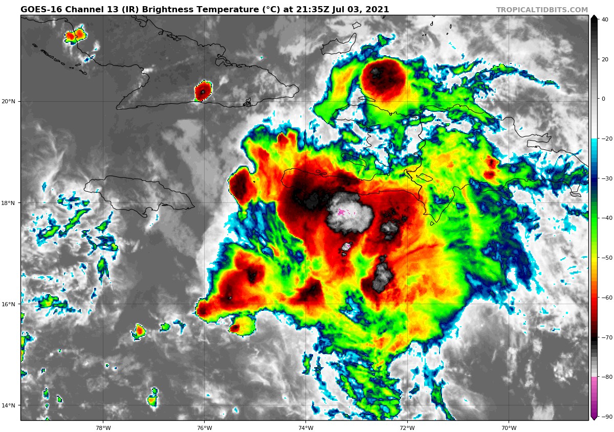
Satellite imagery shows that Elsa looks ragged and disorganized at this time, with bursts of convection occuring near the low-level center and poorly-defined convective banding. Some of this is likely due to the the proximity of the system to Hispaniola. Air Force Reserve and NOAA Hurricane Hunter aircraft have reported reliable 55-60 kt surface wind estimates from the SFMR, along with the latest central pressure report of 1000 mb. The initial intensity remains 60 kt based mainly on the SFMR data.
The initial motion is now 295/24. There is little change in the forecast philosophy from the previous advisory. Elsa is approaching a weakness in the subtropical ridge caused by a large baroclinic trough over the eastern United States. The global models forecast this trough to move eastward into the Atlantic, but the southern portion is likely to split off and become an upper-level low pressure area over the western Gulf of Mexico, with the subtropical ridge over the Atlantic situated to the east of the this low. In response, Elsa should slow its forward motion and turn northwestward during the next 48 h, followed by a general northward motion from 60-96 h and recurvature into the westerlies after that time. The forecast track takes the center near or over southwestern Haiti, Cuba, and the eastern Gulf of Mexico or the Florida Peninsula during the next 3 days or so. After that, the system is likely to cross portions of the southeastern United States on its way into the Atlantic. The new forecast track is changed little from the previous advisory, and it lies near the center of the now reasonably-agreeing track guidance envelope.
In addition to land interaction, Elsa continues to be affected by northwesterly shear that is at least partly due to the fast low-level flow that the storm is embedded in. Some shear is expected to continue through the next 72 h. However, once the system passes the southwestern peninsula of Haiti, there may be less land interaction than previously forecast. The intensity guidance is in good agreement on weakening during the next 48 h, and the GFS, UKMET, and ECMWF show Elsa as a not very vertically aligned system with some separation between the low- and mid-level centers over the southeastern Gulf of Mexico. After that, despite the shear, upper-level divergence associated with the aforementioned upper-level low could allow for some re-intensification as forecast by the HWRF and other models. The new NHC intensity forecast calls for some weakening in the first 48 h and then shows re-intensification over the Gulf of Mexico. Through the first 72 h, the forecast remains at the upper edge of the intensity guidance.
Hurricane warnings remain in effect for portions of Haiti at this time, as there is still the possibility that a short-lived re-intensification might occur due to a convective burst.
Given the remaining uncertainty in the track forecast and the degree of land interaction with Hispaniola and Cuba, users are urged to factor in some of this uncertainty. For reference, average NHC track errors at days 3 and 4 are 125 miles and 150 miles, respectively. The average NHC intensity errors are around 15 mph for both days 3 and 4.
KEY MESSAGES
1. A hurricane warning remains in effect for portions of Haiti, where near-hurricane conditions and dangerous storm surge are expected through this evening.
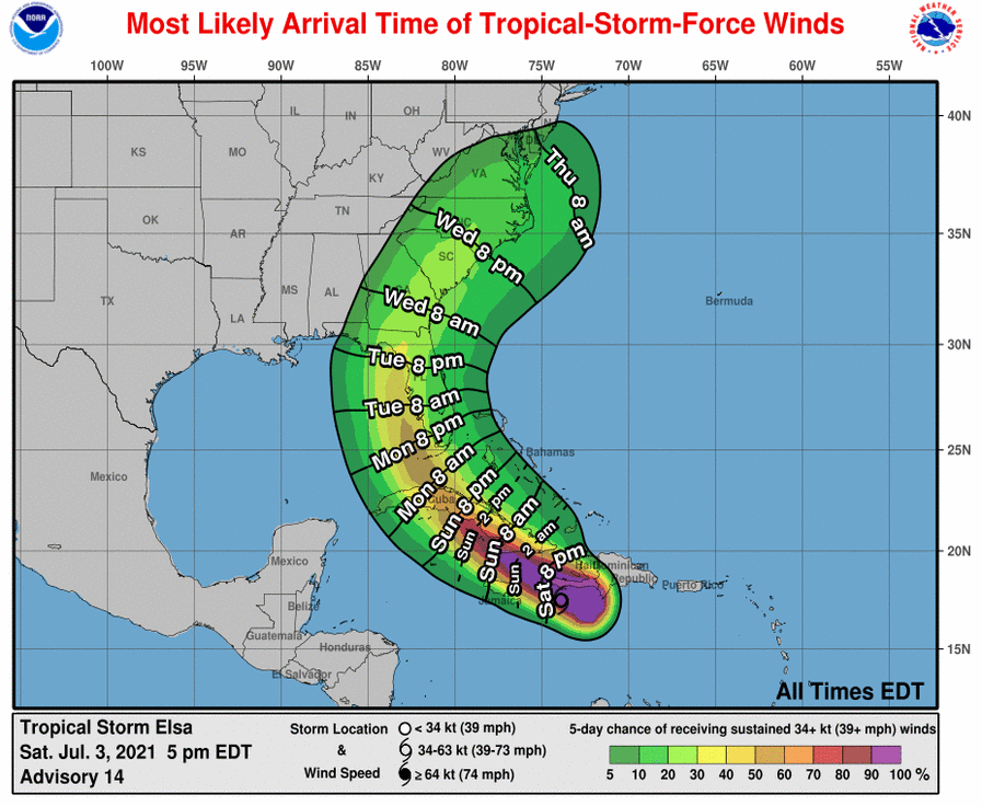
2. Widespread heavy rain will move across southern Hispaniola and Jamaica tonight into Sunday where isolated to scattered flash flooding and mudslides will be possible. Heavy rain will then impact the Cayman Islands and Cuba Sunday into Monday resulting in significant flooding and mudslides over Cuba. As Elsa approaches the Florida Keys and Florida Peninsula early next week, isolated flash flooding and minor river flooding will be possible.
3. Tropical storm conditions and dangerous storm surge are expected with hurricane conditions possible in portions of eastern Cuba beginning early Sunday, with tropical storm conditions possible in central and western Cuba Sunday night and Monday.
4. There is an increasing risk of tropical storm conditions, storm surge, and rainfall impacts beginning Monday in the Florida Keys and the southern Florida Peninsula, and a Tropical Storm Watch is now in effect for portions of the Florida Keys. This risk will spread northward along the Florida Peninsula through Wednesday and reach the coasts of Georgia and the Carolinas Wednesday and Thursday, however uncertainty in the forecast remains larger than usual due to Elsa’s potential interaction with the islands of Hispaniola and Cuba. Interests elsewhere in Florida and along the southeast U.S. coast should monitor Elsa’s progress and updates to the forecast.
Category: ALL POSTS, Severe Weather, Tropical
About the Author (Author Profile)
Scott Martin is an operational meteorologist, professional graphic artist, musician, husband, and father. Not only is Scott a member of the National Weather Association, but he is also the Central Alabama Chapter of the NWA president. Scott is also the co-founder of Racecast Weather, which provides forecasts for many racing series across the USA. He also supplies forecasts for the BassMaster Elite Series events including the BassMaster Classic.Subscribe
If you enjoyed this article, subscribe to receive more just like it.


