10 pm Update: Reconnaissance Aircraft Finds Elsa a Little Weaker as it Moves Slower Between Haiti & Jamaica
SUMMARY OF 10 PM CDT…0300 UTC…INFORMATION
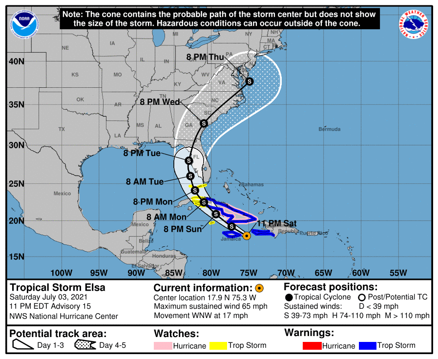
LOCATION…17.9N 75.3W
ABOUT 175 MI…280 KM ESE OF MONTEGO BAY JAMAICA
ABOUT 205 MI…330 KM SE OF CABO CRUZ
MAXIMUM SUSTAINED WINDS…65 MPH…100 KM/H
PRESENT MOVEMENT…WNW OR 295 DEGREES AT 17 MPH…28 KM/H
MINIMUM CENTRAL PRESSURE…1004 MB…29.65 INCHES
WATCHES AND WARNINGS
A Tropical Storm Warning is in effect for…
* Southern portion of Haiti from Port Au Prince to the southern border with the Dominican Republic
* The Cuban provinces of Camaguey, Granma, Guantanamo, Holguin, Las Tunas, Santiago de Cuba, Ciego de Avila, Sancti Spiritus, Villa Clara, and Cienfuegos
* Jamaica
A Hurricane Watch is in effect for…
* The Cuban provinces of Camaguey, Granma, Guantanamo, Holguin, Las Tunas, and Santiago de Cuba
A Tropical Storm Watch is in effect for…
* Cayman Brac and Little Cayman
* The Cuban provinces of Matanzas, Mayabeque, and Havana
* The Florida Keys from Craig Key westward to the Dry Tortugas
FORECAST DISCUSSION & OUTLOOK
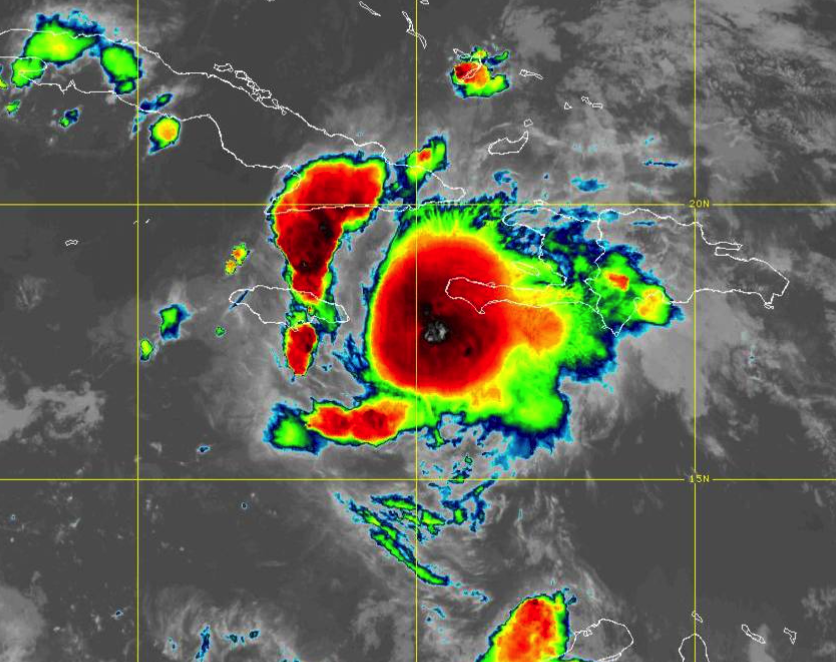
Elsa is undergoing a convective bursting pattern the past few hours, with some cold overshooting tops of -90 deg C east and northeast of the center. However, data from an Air Force Reserve reconnaissance aircraft indicate that this convective increase has not translated into an intensity increase. To the contrary, 5000-ft flight-level and SFMR surface winds have decreased while the central pressure has increased to 1004 mb. Based on the latest recon data, the intensity has been lowered to 55 kt. The aircraft has now climbed to 10,000 ft for safety reasons and will be penetrating the area of intense convection to check for stronger winds there.
The initial motion estimate is now 295/15 kt. Elsa is forecast to gradually move around the western periphery of a deep-layer subtropical ridge over the next 96 hours, accompanied by an additional decrease in forward speed. The latest model guidance has continued to converge along the previous advisory track, with the corrected-consensus models HCCA and FSSE nearly on top of each other. The TCVA simple consensus model is also similar to the HCCA and FSSE models. However, out of respect for the slightly more westward GFS and GFS-ensemble models, which have performed admirably thus far with Elsa, the new official forecast lies a tad west of the aforementioned consensus models and lies nearly on top of the previous advisory track.
After interacting with the mountainous terrain of southwestern Haiti, which could have caused some disruption in the low-level field despite the center remaining offshore, little change in intensity is expected tonight. However, some slight restrengthening could occur by Sunday afternoon as Elsa approaches the south-central coast of Cuba where the sea-surface temperatures are quite warm at more than 30 deg C and the water is deep. Weakening is expected after the cyclone moves across west-central Cuba, followed again by some slight restrengthening after Elsa emerges over the warm Gulf Stream in the Straits of Florida. Westerly vertical wind shear increasing to near 20 kt by 96 hours should prevent any significant strengthening from occurring. Elsa should become a very asymmetrical tropical cyclone late on day 3 and on day 4 with most of the heavy rain and strongest winds displaced along and to the east of the forecast track. The initial intensity is similar to the previous advisory and closely follows the simple and corrected consensus models.
Given the remaining uncertainty in the track forecast and the degree of land interaction with Hispaniola and Cuba, users are urged to factor in some of this uncertainty. For reference, average NHC track errors at days 3 and 4 are 125 miles and 150 miles, respectively. The average NHC intensity errors are around 15 mph for both days 3 and 4.
KEY MESSAGES
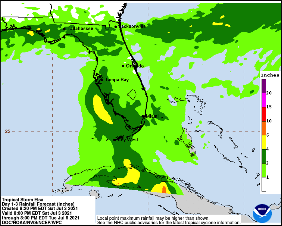
1. Widespread heavy rain will move across southern Haiti and Jamaica tonight into Sunday where isolated to scattered flash flooding and mudslides will be possible. Heavy rain will then impact the Cayman Islands and Cuba Sunday into Monday resulting in significant flooding and mudslides over Cuba. As Elsa approaches the Florida Keys and Florida Peninsula early next week, isolated flash flooding and minor river flooding will be possible.
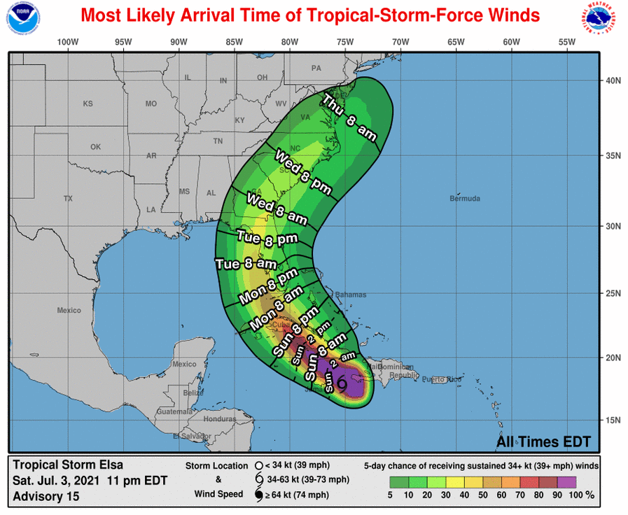
2. Tropical storm conditions and dangerous storm surge are expected with hurricane conditions possible in portions of eastern Cuba beginning early Sunday, with tropical storm conditions possible in central and western Cuba Sunday night and Monday.
3. There is an increasing risk of tropical storm conditions, storm surge, and rainfall impacts beginning Monday in the Florida Keys and the southern Florida Peninsula, and a Tropical Storm Watch is now in effect for portions of the Florida Keys. This risk will spread northward along the Florida Peninsula through Wednesday and reach the coasts of Georgia and the Carolinas Wednesday and Thursday, however, uncertainty in the forecast remains larger than usual due to Elsa’s potential interaction with the islands of Hispaniola and Cuba. Interests elsewhere in Florida and along the southeast U.S. coast should monitor Elsa’s progress and updates to the forecast.
Category: ALL POSTS, Severe Weather, Tropical
About the Author (Author Profile)
Scott Martin is an operational meteorologist, professional graphic artist, musician, husband, and father. Not only is Scott a member of the National Weather Association, but he is also the Central Alabama Chapter of the NWA president. Scott is also the co-founder of Racecast Weather, which provides forecasts for many racing series across the USA. He also supplies forecasts for the BassMaster Elite Series events including the BassMaster Classic.Subscribe
If you enjoyed this article, subscribe to receive more just like it.


