

10 am Update: Center of Elsa Over Eastern Long Island
SUMMARY OF 10 AM CDT…1500 UTC…INFORMATION
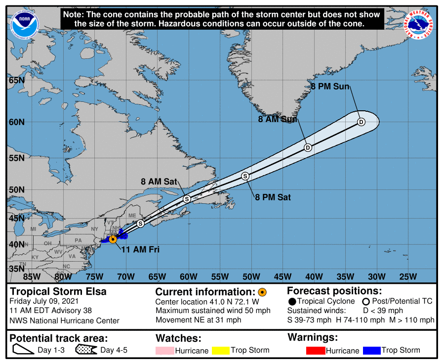
LOCATION…41.0N 72.1W
ABOUT 10 MI…20 KM WSW OF MONTAUK POINT NEW YORK
ABOUT 110 MI…175 KM W OF NANTUCKET MASSACHUSETTS
MAXIMUM SUSTAINED WINDS…50 MPH…85 KM/H
PRESENT MOVEMENT…NE OR 45 DEGREES AT 31 MPH…50 KM/H
MINIMUM CENTRAL PRESSURE…1000 MB…29.53 INCHES
WATCHES AND WARNINGS
A Tropical Storm Warning is in effect for…
* Long Island from East Rockaway Inlet to the eastern tip along the south shore and from Port Jefferson Harbor eastward on the north shore
* New Haven, Connecticut to Merrimack River, Massachusetts including Cape Cod, Block Island, Martha’s Vineyard, and Nantucket
DISCUSSION AND OUTLOOK
The extratropical transition of Elsa is well underway. A frontal boundary located over southern New England nearly wraps into the circulation center, and the primary area of cold cloud tops and heavy rainfall has now shifted to the northwestern portion of the cyclone. Elsa is expected to complete its extratropical transition this afternoon. Buoy and surface observations indicate that the cyclone’s intensity has changed little since early this morning. Based on those data, Elsa’s peak winds and minimum pressure remain 45 kt and 1000 mb for this advisory, respectively.
Elsa continues to move quickly northeastward or 045/27 kt. The post-tropical cyclone is forecast to continue accelerating northeastward over the next day or two as it remains embedded within deep-layer southwesterly flow. After 48 hours, the system is expected to slow before it dissipates over the north Atlantic around day 3. The track guidance remains in good agreement, but has shifted slightly southward after 24 hours and the NHC forecast has been adjusted accordingly.
Little change in strength is anticipated in the short-term as Elsa completes its extratropical transition. After that time, gradual weakening is anticipated and the wind speed forecast calls for the system to weaken below gale-force in a couple of days. The global models show the post-tropical cyclone dissipating over the north Atlantic by early next week, and the official forecast follows suit.
KEY MESSAGES
1. As Elsa moves near southern and coastal New England today, heavy rainfall could lead to considerable flash and urban flooding.
2. Tropical storm conditions are expected to continue in portions of the warning area in Long Island and southern New England through this afternoon. Gusty winds are expected over portions of Atlantic Canada tonight and Saturday.
All images, forecasts, and documents are courtesy of their respective publishers.
About the Author (Author Profile)
Scott Martin is an operational meteorologist, professional graphic artist, musician, husband, and father. Not only is Scott a member of the National Weather Association, but he is also the Central Alabama Chapter of the NWA president. Scott is also the co-founder of Racecast Weather, which provides forecasts for many racing series across the USA. He also supplies forecasts for the BassMaster Elite Series events including the BassMaster Classic.Subscribe
If you enjoyed this article, subscribe to receive more just like it.


