

Sunday Weather Xtreme: Level 1 out of 5 Severe Weather Threat Today for Parts of the Area
Saturday featured more splash and dash showers and storms, although some were more splash than dash, like Friday’s storms. A few areas enjoyed some nice cooling with the afternoon storms, like Bessemer, where the mercury dropped from 86F to 72F in a short time during the late afternoon. The Birmingham Airport reached 90 degrees for the ninth time this summer. By this time in the summer, we should have normally seen 15 such days, so we are grateful to be a little behind in this department. It was 89F at Anniston and Tuscaloosa, 88F at Calera, and 87F at Auburn.
ON THE WEATHER MAPS THIS MORNING: An upper-level trough is building up momentum over the Midwest. This trough will close off into one of those big bowling ball upper lows later today. It will lumber eastward through the Ohio Valley through Tuesday before lifting out to the northeast. This will assure us of continued enhanced chances of showers and storms each day through Tuesday. Highs will be in the upper 80s today, with middle 80s Monday and Tuesday. Lows will be in the 70-degree range. The departure of the trough will be followed by some warmer and drier conditions.
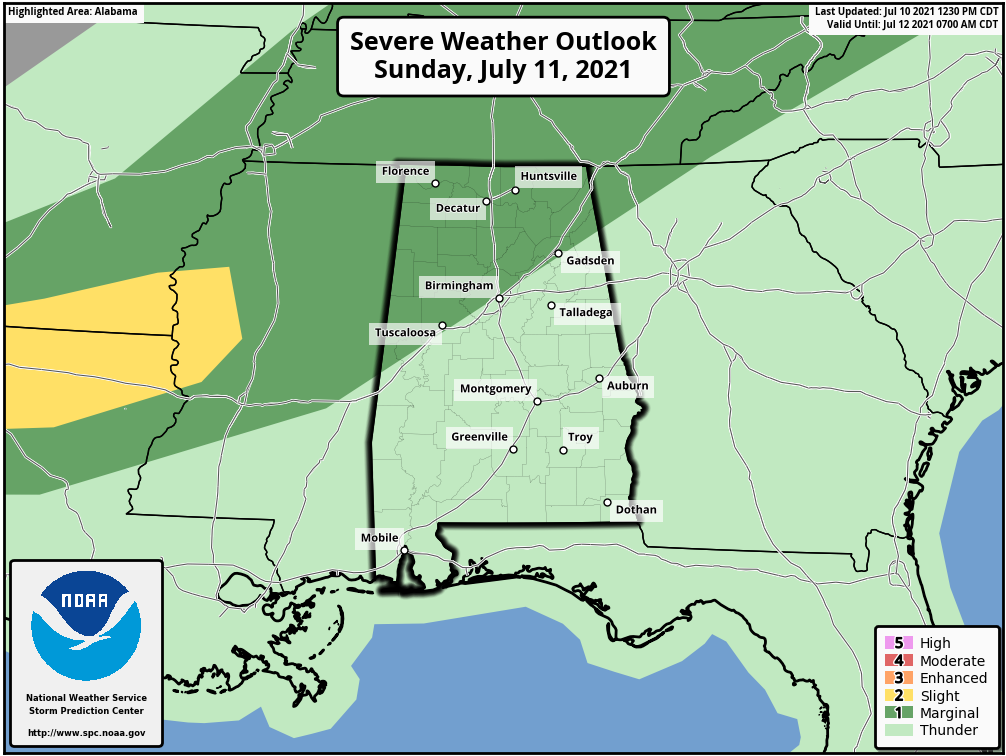
LEVEL 1 SEVERE WEATHER THREAT TODAY: Our storms today are getting an early start over northwestern sections of the state. They will spread southeastward through the late morning and afternoon hours. Some of them could be on the strong side, or even severe in some cases, with damaging winds the main threat.
MIDWEEK: Those highs and lows will bounce back a bit starting Wednesday and Thursday with fewer clouds and showers around. Look for highs between 88-90 and lows to fall into the lower 70s.
THE WEEKEND AND INTO THE FOLLOWING WEEK The subtropical ridge will build just off the South Atlantic coast of the U.S. later in the week and link hands with the western ridge to provide fairly typical Alabama July weather for the weekend and into the next week: hot and humid, with scattered afternoon and evening storms. You know the drill. We will add a couple of 90 degree readings to those stats quoted earlier, but not too hot, with highs in the upper 80s generally.
VOODOO TERRITORY: Looks like a weak trough will hang out over the Southeast as we head into the weekend of the 24th. This may increase our shower and storm chances again. No big rain chances to write about though and temperatures should be a little below normal with the trough around. The normal high for the rest of the month at Birmingham is 91F each day.
TROPICS: Well, we have Elsa out of the way, so let’s look at the rest of the Atlantic, Caribbean, and Gulf of Mexico for signs as to when we might see our next named storm. It appears that no tropical development is expected across the Atlantic, Caribbean, and Gulf of Mexico through this weekend and very likely through all of next week. In fact, it is possible that we may not see any other tropical systems develop for the next couple of weeks or so. We are entering a downward pulse of the Madden Julian Oscillation in the Atlantic Basin, which makes it harder for tropical disturbances to develop. The next upward pulse is expected to arrive toward the end of the month, so we will probably see activity on the upswing by then and into early August. We have already seen the earliest fifth named system, so it is likely we will have a very busy season. Phil Klotzbach and his team have upped their forecast to 20 named storms, which could be low. It is also concerning that we are seeing a pattern that has steered storms toward the U.S. Hurricane seasons seem to lock that “muscle memory” into place and storms trend to follow similar general paths. So I think it will not only be a busy season, it could be another bad season for U.S. landfalls. Stay tuned.
BEACHCAST: Fairly typical weather for July along the beautiful beaches of Alabama and Northwest Florida. A mix of sun and storms each day, with hot afternoon temperatures ranging between the upper 80s and 90 degrees, and lows in the steamy middle 70s. Expect about 5-7 hours of intense sunshine each day with rain chances ranging between 50-70%. Water temperatures are running in the lower 80s, so the sea breeze is a little less effective than earlier in the season. The rip current risk is moderate for the coming few days, and yellow flags will be flying along the beaches along with purple flags in some beach locales for dangerous marine life (jellyfish).
Click here to see the Beach Forecast Center page.
NATIONALLY: California and Nevada are at the epicenter of the second major heatwave of the summer season. Excessive heat warnings cover much of the western United States from Central Washington through Oregon and Idaho to much of California, Nevada, Utah, and parts of Arizona and New Mexico. Expected highs today include 115F at Las Vegas and 113F at Fresno. Both of these readings would be within a couple of degrees of their all-time record high temperatures. Elsewhere, a brief tornado touched down northwest of Springfield, IL Saturday afternoon. But no damage was reported.
DANCING WITH THE STATS: Las Vegas tied its all-time record high of 117F yesterday as the mercury reached 117F. The high of 129F at Death Valley CA fell just 5 degrees short of the world’s hottest reliably recorded temperature, recorded at Greenland Ranch in Death Valley in 1913.
WEATHERBAND: The American Meteorological Society has created a club for all of us! The weather enthusiasts of the world! You will connect with weather enthusiasts and experts alike. Special Weather Band items will identify you with the community. You’ll get special discounts on WeatherWise magazine and other merchandise as well as a special newsletter! Join today! https://amsweatherband.org/index.cfm/weatherband/membership/
ADVERTISE WITH US: Deliver your message to a highly engaged audience by advertising on the AlabamaWX.com website. The site enjoyed over 29 MILLION page views in the past 12 months. Don’t miss out! We can customize a creative, flexible, and affordable package that will suit your organization’s needs. Contact me, Bill Murray, at (205) 687-0782, and let’s talk.
WEATHERBRAINS: This week, the panel will entertain a couple of meteorologists from Spire, a company that is using Radio Occultation to help improve weather forecasts. Check out the show at www.WeatherBrains.com. You can also subscribe on iTunes. You can watch the show live at live.bigbrainsmedia.com or on James’ YouTube Channel You will be able to see the show on the James Spann 24×7 weather channel on cable or directly over the air on the dot 2 feed.
ON THIS DATE IN 1961: The Major League Baseball All-Star game at Candlestick Park in San Francisco was buffeted by strong winds. Giants pitcher Stu Miller was called for a balk when the gusting winds blew him off the mound in the ninth inning. Baserunners advanced and tied the score. The National League won the windy contest, 5-4 in 10 innings, but one AL run was chalked up to the weather. Follow my weather history tweets on Twitter. I am @wxhistorian at Twitter.com.
Category: Alabama's Weather, ALL POSTS, Severe Weather
About the Author (Author Profile)
Bill Murray is the President of The Weather Factory. He is the site's official weather historian and a weekend forecaster. He also anchors the site's severe weather coverage. Bill Murray is the proud holder of National Weather Association Digital Seal #0001 @wxhistorianSubscribe
If you enjoyed this article, subscribe to receive more just like it.


