Sunday Weather Xtreme: Wary Eye on the Tropics, But Typical Summertime Fare for Us For Now
Saturday was a fairly typical summertime day across Central Alabama, with scattered showers and storms developing generally east of I-59. Temperatures were dependent on nearby thunderstorm activity, with Birmingham and Calera stopping short of 90 degrees, while Tuscaloosa and Anniston both made it to that benchmark. One of the heavier storms formed over southwestern Jefferson County and dumped some heavy rain as it pushed eastward along with some lightning. Rainfall amounts were light. My rain gauge collected 0.46 inches in that shower around 4:30 p.m. More fairly typical summertime weather is in store for Alabama. Note I said “fairly” there.
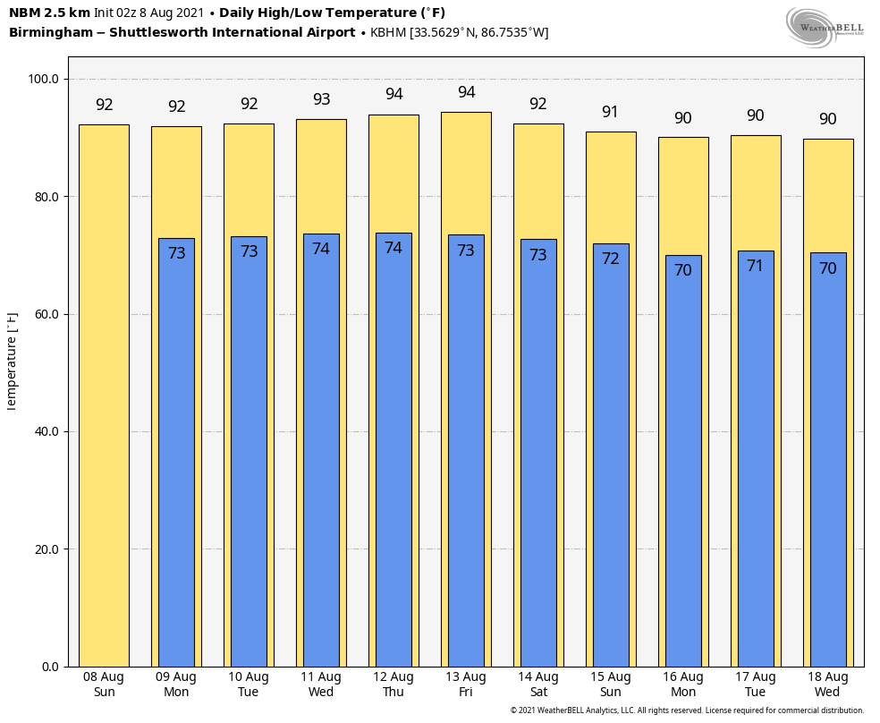
ON THE WEATHER MAPS: In the upper levels of the atmosphere, we see a trough of low pressure exiting the Carolinas, with a building ridge across the Southeast. That ridge will give us those summerlike conditions for the week ahead, but it will be a “dirty” ridge, meaning that moisture is trapped underneath it, rain chances may be a little more elevated than usual each afternoon. Expect partly cloudy skies with scattered afternoon and evening storms each day. Highs will be in the lower 90s and lows will be in the middle 70s.
SNEAK PEEK NEXT WEEKEND: More of the same for the week, except perhaps a few more showers and storms later into the overnights as a front tries to sag southward over the Mid-Atlantic. Highs will trend back toward the 90-degree mark.
VOODOO: More of the same out toward the end of the modeling, with above-normal rainfall chances, but no total washouts. Typical summertime heat and humidity.
IN THE TROPICS: Three disturbances are marching across the Main Development Region of the North Atlantic right now, but the NHC is not very high on any of their chances for immediate development. I do think that the middle system, which is about 1,000 miles east of the Lesser Antilles has some chance of developing into a tropical depression or tropical storm in the coming days and perhaps impacting the northern islands and perhaps the Greater Antilles by next weekend. The GFS favors the westernmost wave and brings it to near South Florida late in the week. It could go anywhere from the Gulf to the Outer Banks if it does develop. Conditions are generally becoming more favorable and the season could turn back active once again here shortly. Our next named storm will be Fred. That name has been used twice in the Atlantic, in 2009 and 2015. Both were Cape Verde storms that didn’t amount to much, although the 2015 iteration was the first hurricane to actually pass through the Cape Verde Islands. Then there was 1979’s Frederic (no relation) that you all remember.
BEACHCAST: Fairly typical deep summertime weather along the beautiful beaches of Alabama and Northwest Florida with hot and humid conditions and scattered showers and storms, mainly during the afternoon and evening hours. Highs will be in the lower 90s and lows in the lower 70s. Expect 7-9 hours of sunshine each day with a slight cooling sea breeze. The rip current index will be low all week with the surf running less than 1 foot. Water temperatures are running in the lower 80s.
Click here to see the Beach Forecast Center page.
NATIONALLY: Strong thunderstorms across southern Wisconsin caused severe weather late Saturday afternoon. A tornado was reported on the ground by the Blue River Fire Department near that community in Grant County just before 5 p.m. A TDS was reported on radar as well. The town of Boscobel was hit hard by a tornado with six homes destroyed and 15 damaged. Many power poles and trees were down and most roads impassable. Fortunately, no injuries were reported.
DANCING WITH THE STATS: Some heavy rains Friday along the I-4 Corridor in Central Florida. 5.14 inches of rain at the Orlando Executive Airport was one of the most impressive totals. 2.42 inches at Orlando International was a record for the date, as was the 1.26 inches at Daytona Beach.
ADVERTISE WITH US: Deliver your message to a highly engaged audience by advertising on the AlabamaWX.com website. The site enjoyed over 28 MILLION page views in the past 12 months. Don’t miss out! We can customize a creative, flexible, and affordable package that will suit your organization’s needs. Contact me, Bill Murray, at (205) 687-0782, and let’s talk.
WEATHERBRAINS: This week, the panel chatted with Dr. Jonathan Martin from the University of Wisconsin. He has recently written a fascinating account about the life of Reginald Sutcliffe, a British meteorologist who made an enormous contribution to our knowledge of the atmosphere. Check out the show at www.WeatherBrains.com. You can also subscribe on iTunes. You can watch the show live at live.bigbrainsmedia.com or on James’ YouTube Channel You will be able to see the show on the James Spann 24×7 weather channel on cable or directly over the air on the dot 2 feed.
ON THIS DATE IN 1980: After weakening near Haiti and Jamaica, Hurricane Allen was again strengthening and a minimum pressure of 899 mb (26.55 inches) was recorded by a NOAA aircraft on the 7th when it was off the Yucatan Peninsula. Only Hurricane Wilma (882 mb in 2005), Hurricane Gilbert (888 mb in 1988) and the infamous Labor Day hurricane of 1935 with a central pressure of 892 mb were lower than Allen’s 899 mb central pressure. Emergency management officials all along the Gulf Coast were preparing for a possible onslaught from Allen’s destructive winds and forecasters were desperately trying to calculate which way the monster storm would go when it entered the Gulf of Mexico. 250,000 people were being evacuated along the Texas coast. Offshore oil rigs were shuttling workers to safety via helicopters. One of the choppers crashed into the Gulf, killing 13 people. Allen would lose strength again near the Yucatan Peninsula but regained it over the open waters of the Gulf of Mexico before eventually moving into Texas north of Brownsville. Follow my weather history tweets on Twitter. I am @wxhistorian at Twitter.com.
Category: Alabama's Weather, ALL POSTS, Tropical
About the Author (Author Profile)
Bill Murray is the President of The Weather Factory. He is the site's official weather historian and a weekend forecaster. He also anchors the site's severe weather coverage. Bill Murray is the proud holder of National Weather Association Digital Seal #0001 @wxhistorianSubscribe
If you enjoyed this article, subscribe to receive more just like it.


