4 pm Advisory — PTC-7 Upgraded to a Tropical Depression, May Become Tropical Storm Grace Within the Next Few Hours
SUMMARY OF 4 PM CDT INFORMATION
LOCATION…15.4N 51.8W
ABOUT 675 MI…1085 KM E OF THE LEEWARD ISLANDS
MAXIMUM SUSTAINED WINDS…35 MPH…55 KM/H
PRESENT MOVEMENT…W OR 275 DEGREES AT 22 MPH…35 KM/H
MINIMUM CENTRAL PRESSURE…1010 MB…29.83 INCHES
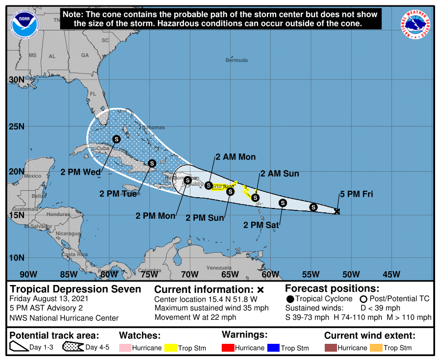
WATCHES AND WARNINGS
A Tropical Storm Watch is in effect for…
* Antigua and Barbuda, Anguilla, St. Kitts and Nevis, and Montserrat
* Saba and Sint Eustatius
* Sint Maarten
* St. Martin and St. Barthelemy
* British Virgin Islands
* U.S. Virgin Islands
* Puerto Rico, including Vieques and Culebra
FORECAST DISCUSSION
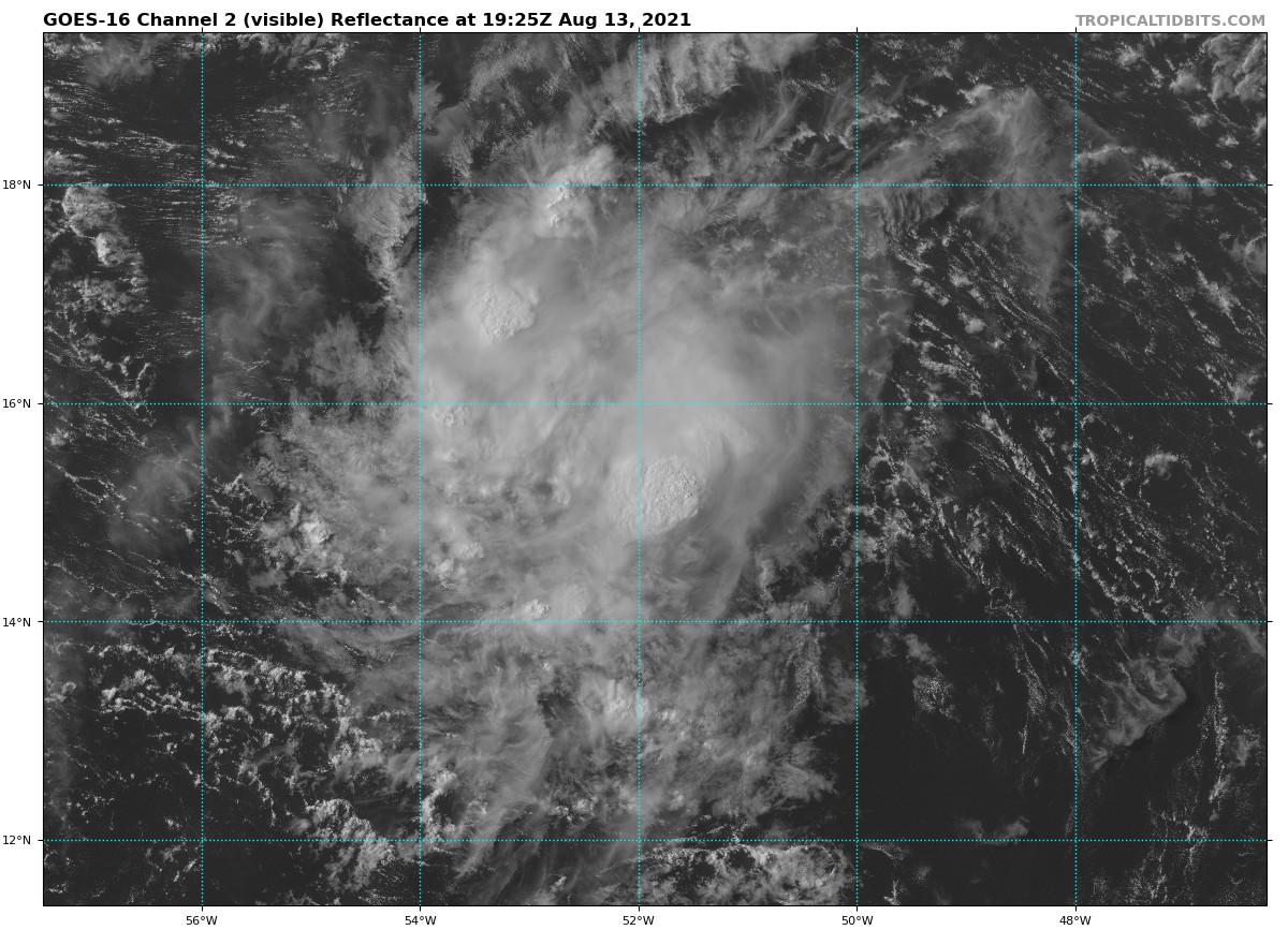
Over the past few hours, the system moved just to the north of a buoy owned by the Woods Hole Oceanographic Institute. The buoy’s winds backed from northwest to west to south, indicating that the system has a closed surface circulation. In addition, Dvorak estimates from TAFB and SAB were a unanimous T2.0, and the system is therefore being designated as a tropical depression on this advisory. Maximum winds remain 30 kt based on earlier ASCAT data and the Dvorak estimates.
The circulation has closed off despite the depression moving quickly westward (275 degrees) at about 19 kt. The track guidance is tightly clustered during the first 48-60 hours, with the depression being driven quickly westward across the Leeward Islands and toward the Greater Antilles by ridging to the north. After 60 hours, there is considerably more spread, with the regional dynamical models keeping the system farther south over the Caribbean Sea, and most of the other models indicating a turn toward the west-northwest, following a track similar to Tropical Depression Fred. The NHC track forecast generally favors the latter scenario and is very close to the HCCA and TVCN consensus aids.
During the next 2 days, the depression is expected to move beneath an upper-level ridge axis, which should allow the deep-layer shear to fall below 10 kt, with the system also moving over warmer waters and through an environment of increased moisture. However, the depression’s fast motion, as well as the possible development of some mid-level westerly shear, could stunt the rate of strengthening. Due to these conflicting factors, the NHC intensity forecast remains on the conservative side and is not quite as high as the solutions shown by the SHIPS and HCCA models. The HWRF model is quite aggressive, bringing the depression to hurricane strength by day 3, but that model is an extreme outlier compared to the other guidance. After 48 hours, the current forecast takes the center of the depression over Puerto Rico and Hispaniola, a scenario that would cause weakening and suppress the system’s intensity. As is typically the case, the system could get stronger than shown in the official forecast if it ends up moving over less land, or dissipate entirely if it moves over land for too long.
KEY MESSAGES
1. Tropical storm conditions are possible in portions of the Leeward Islands late Saturday or early Sunday, and over the Virgin Islands and Puerto Rico on Sunday. The risk of strong winds will then spread westward to the Dominican Republic Sunday night and Monday.
2. Heavy rainfall could lead to flash and urban flooding over the Leeward and Virgin Islands. Across Puerto Rico, heavy rainfall may lead to flash, urban and small stream flooding, along with the potential for mudslides.
3. There is a risk of wind and rainfall impacts across Haiti, the Turks and Caicos Islands, the southeastern Bahamas, and Cuba next week, and interests in those areas should monitor the progress of this system.
About the Author (Author Profile)
Scott Martin is an operational meteorologist, professional graphic artist, musician, husband, and father. Not only is Scott a member of the National Weather Association, but he is also the Central Alabama Chapter of the NWA president. Scott is also the co-founder of Racecast Weather, which provides forecasts for many racing series across the USA. He also supplies forecasts for the BassMaster Elite Series events including the BassMaster Classic.Subscribe
If you enjoyed this article, subscribe to receive more just like it.


