Expected Central Alabama Impacts as of the Latest Forecast Track of Fred
Post by Bill Murray & Scott Martin
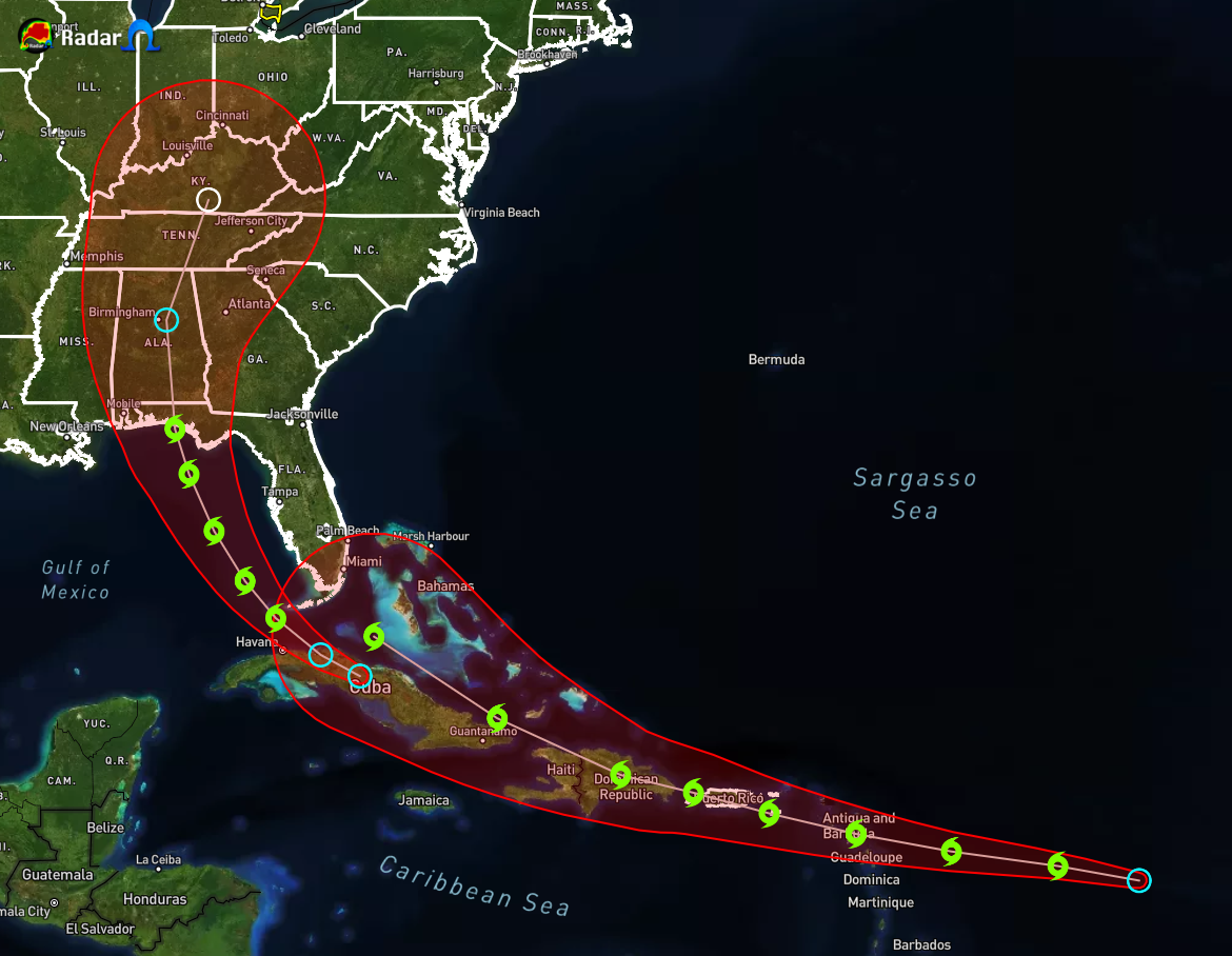
The 4 p.m. track issued by the National Hurricane Center shifted substantially to the west, which has implications for the beautiful Gulf beaches as well as Central and South Alabama.
I believe the center of the storm is reforming south of the Cuban coast, which is significant for a couple of reasons. One, the shear appears to be less over the western Caribbean. Two, it pushes the storms potentially further out into the central Gulf, west of the heavier land interaction with the Florida Peninsula. So it could be a little stronger than we are thinking as well.
The current forecast track has the storm centered just north of the Cuban coast, about 700 miles southeast of Mobile. It will pass just west of Key West tomorrow afternoon. By Sunday morning, it will be about 150 miles west southwest of Fort Myers, or about 375 miles southeast of Mobile. Landfall would come around noon on Monday near Destin. Tropical storm force winds will reach the coast around Cape San Blas, Mexico Beach, and Panama City before sunrise Monday. These winds will spread north and westward along the coast through the 30A communities during the morning and into the Destin area by 9 a.m. Winds should diminish during the afternoon hours along the coast.
The current forecast error cone extends from Dauphin Island to the Florida Big Bend area, south of Tallahassee. What that means is the center could reasonably be anywhere from Mobile Bay to Tallahassee at landfall. So don’t focus on one landfall forecast.
A track to the west, toward Gulf Shores, could bring those winds to the Alabama coast and western Panhandle coast a little later on Monday. A track further east, toward Panama City or Apalachicola, could result in stronger winds for those areas late Sunday night into Monday morning.
On the current forecast track, what could potentially be a strong Tropical Storm Fred will make landfall on the west-central Gulf Coast of the Florida Panhandle on Monday afternoon. Before that occurs, we’ll have the outer rain bands moving northward through the southern parts of Central Alabama, possibly very early on Monday morning, and eventually moving into the rest of the area. The center will roughly be moving up and just to the east of the I-65 corridor throughout the latter part of the day on Monday and into a good portion of Tuesday.
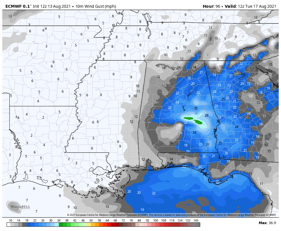
During that time frame, we could potentially see winds of 20-30 mph with gusts up to 35-40 mph (tropical-storm-force), especially close and just east of where the center tracks. The higher risk for those higher wind gusts will be over the southeastern quarter of Central Alabama, especially east of I-65 and south of I-20.
Of course, if the storm were to grow stronger, perhaps becoming a hurricane, the impact from winds will be greater.
Also, on the eastern side of the area, there will be a small risk of a few brief spin-up tropical type tornadoes as Fred pushes northward through the area.
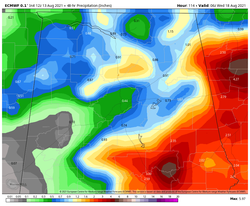
While rainfall amounts are expected to be heavy in the more intense rain bands, amounts should be manageable and stay below flash flood criteria. For now, the European model has precipitation totals ranging from ½-inch to as high as nearly 4 inches, with slightly higher localized amounts, across Central Alabama from northwest to southeast. However, at the same time, we’ll have a surface front approaching from the west and northwest that could enhance the rainfall amounts and add a little more instability to the atmosphere for a slightly higher threat of damaging winds and a few tornadoes. We’ll get a better idea on those parameters as the forecast track becomes more concrete over the weekend. For now, the Storm Prediction Center does not have an outline severe storm risk on day 4 (Monday).
A NOTE ON TROPICAL DEPRESSION SEVEN
The newly formed Depression should be Tropical Storm Grace by tonight. It will impact the northern Leeward Islands late tomorrow night and Sunday. It will move through the Greater Antilles (Puerto Rico and Hispaniola Sunday and early Monday as a strong tropical storm, but the land interaction would weaken it. A track 100 miles to the north or south would mean a much stronger storm or hurricane.
The eventual track of Grace carries it near South Florida on Wednesday. But it could be south of Cuba heading for the Gulf or in the Bahamas, threatening the southeastern coast. It will be an interesting week. Stay tuned.
Category: Alabama's Weather, ALL POSTS, Severe Weather, Tropical
About the Author (Author Profile)
Scott Martin is an operational meteorologist, professional graphic artist, musician, husband, and father. Not only is Scott a member of the National Weather Association, but he is also the Central Alabama Chapter of the NWA president. Scott is also the co-founder of Racecast Weather, which provides forecasts for many racing series across the USA. He also supplies forecasts for the BassMaster Elite Series events including the BassMaster Classic.Subscribe
If you enjoyed this article, subscribe to receive more just like it.


