7 am Advisory — Grace Moving Quickly Westward Toward the Leeward Islands
SUMMARY OF 700 AM CDT INFORMATION
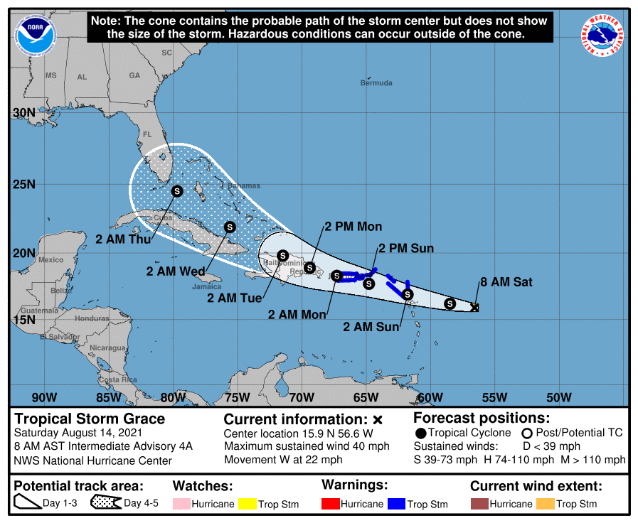
LOCATION…15.9N 56.6W
ABOUT 355 MI…570 KM ESE OF THE LEEWARD ISLANDS
MAXIMUM SUSTAINED WINDS…40 MPH…65 KM/H
PRESENT MOVEMENT…W OR 280 DEGREES AT 22 MPH…35 KM/H
MINIMUM CENTRAL PRESSURE…1007 MB…29.74 INCHES
WATCHES AND WARNINGS
A Tropical Storm Warning is in effect for…
* Antigua and Barbuda, Anguilla, St. Kitts and Nevis, and Montserrat
* Saba and Sint Eustatius
* Sint Maarten
* St. Martin and St. Barthelemy
* British Virgin Islands
* U.S. Virgin Islands
* Puerto Rico, including Vieques and Culebra
DISCUSSION AND OUTLOOK
At 800 AM AST (1200 UTC), the center of Tropical Storm Grace was located near latitude 15.9 North, longitude 56.6 West. Grace is moving toward the west near 22 mph (35 km/h). A motion toward the west with a gradual decrease in forward speed is expected during the next few days. On the forecast track, the center of the storm is forecast to move over the Leeward Islands tonight, over the Virgin Islands and Puerto Rico on Sunday, and then over the Dominican Republic on Monday.
Maximum sustained winds are near 40 mph (65 km/h) with higher gusts. Some strengthening is forecast during the next couple of days. Weakening is expected early next week as the system interacts with the Greater Antilles. Grace is a small tropical storm. Tropical-storm-force winds extend outward up to 25 miles (35 km) from the center.
The estimated minimum central pressure is 1007 mb (29.74 inches).
HAZARDS AFFECTING LAND
WIND: Tropical storm conditions are expected within the warning area over the Leeward Islands by tonight or early Sunday, and the Virgin Islands and Puerto Rico beginning on Sunday.
RAINFALL: The system is expected to produce the following rainfall amounts later today into Monday:
Over the northern Leeward Islands and Virgin Islands…3 to 6 inches. This rainfall may produce scattered areas of flash and urban flooding.
Over Puerto Rico…3 to 6 inches. Heavy rainfall could lead to flash, urban, and small stream flooding as well as potential mudslides.
Heavy rainfall from this system could impact Florida late next week.
About the Author (Author Profile)
Scott Martin is an operational meteorologist, professional graphic artist, musician, husband, and father. Not only is Scott a member of the National Weather Association, but he is also the Central Alabama Chapter of the NWA president. Scott is also the co-founder of Racecast Weather, which provides forecasts for many racing series across the USA. He also supplies forecasts for the BassMaster Elite Series events including the BassMaster Classic.Subscribe
If you enjoyed this article, subscribe to receive more just like it.


