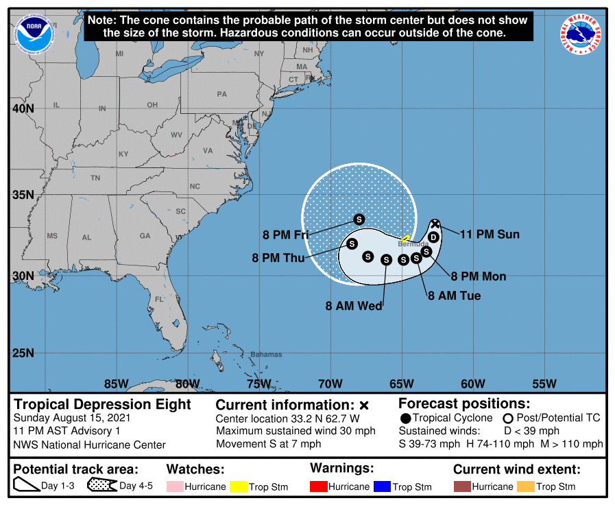
10 PM Advisory — Tropical Depression 8 Forms Northeast of Bermuda
SUMMARY OF 10 PM CDT INFORMATION
LOCATION…33.2N 62.7W
ABOUT 135 MI…220 KM ENE OF BERMUDA
MAXIMUM SUSTAINED WINDS…30 MPH…45 KM/H
PRESENT MOVEMENT…S OR 175 DEGREES AT 7 MPH…11 KM/H
MINIMUM CENTRAL PRESSURE…1014 MB…29.95 INCHES
WATCHES AND WARNINGS
A Tropical Storm Watch is in effect for…
* Bermuda
FORECAST DISCUSSION
A small, well-defined low pressure system located just east-northeast of Bermuda has produced persistent deep convection since this morning. Radar imagery from Bermuda along with geostationary and polar orbiting microwave satellite data show that the convection is sufficiently well organized to meet the definition for a tropical cyclone. Therefore, advisories have been started on Tropical Depression Eight. The initial intensity is set at 25 kt, based on believable winds near that value in a pair of recent ASCAT overpasses. Dvorak estimates from TAFB and SAB were a little higher, so this estimate could be slightly conservative.
Confidence in the forecast is reasonably high for the next 48 to 72 h. The depression should make a slow clockwise turn around Bermuda, steered by a mid-level ridge currently centered off the coast of the Carolinas. Warm SSTs should provide ample fuel to support at least slight strengthening during this period, despite expected northerly shear, and this is shown by all of the intensity guidance. The NHC forecast is very near the multi-model consensus for both track and intensity through that period.
Beyond 72 h, the track and intensity models diverge quickly. The HWRF and COAMPS-TC models rapidly intensify the system to major hurricane strength. A stronger, deeper vortex would likely be steered generally westward through the end of the forecast period, influenced by a deeper-layer steering flow. However, the global models have a much weaker, shallower system which turns northward, and then possibly accelerates northeastward by day 5. As a result, the spread in the track guidance is nearly 800 n mi by day 5, with the GFS and HWRF taking the extreme positions to the northeast and southwest, respectively. The official track forecast takes a middle approach, and is between the various consensus aids at days 4 and 5. The NHC intensity forecast is slightly more conservative, and is below the consensus at the end of the period. Significant changes to the forecast may be required in subsequent advisory packages.
KEY MESSAGES
About the Author (Author Profile)
Scott Martin is an operational meteorologist, professional graphic artist, musician, husband, and father. Not only is Scott a member of the National Weather Association, but he is also the Central Alabama Chapter of the NWA president. Scott is also the co-founder of Racecast Weather, which provides forecasts for many racing series across the USA. He also supplies forecasts for the BassMaster Elite Series events including the BassMaster Classic.Subscribe
If you enjoyed this article, subscribe to receive more just like it.


