

10 am Advisory — Grace Weakening Rapidly, Still Causing Heavy Rains & Flooding Over Parts of East-Central Mexico
SUMMARY OF 1000 AM CDT…1500 UTC…INFORMATION
———————————————–
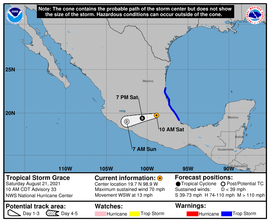
LOCATION…19.7N 98.9W
ABOUT 25 MI…40 KM NNE of CIUDAD DE MEXICO
MAXIMUM SUSTAINED WINDS…70 MPH…110 KM/H
PRESENT MOVEMENT…WSW OR 250 DEGREES AT 13 MPH…20 KM/H
MINIMUM CENTRAL PRESSURE…990 MB…29.24 INCHES
WATCHES AND WARNINGS
——————–
A Tropical Storm Warning is in effect for…
* The coast of mainland Mexico from Puerto Veracruz to Barra del Tordo
FORECAST DISCUSSION
——————–
Grace has continued to move over east-central Mexico since making landfall around 0600 UTC. Visible satellite images show that the system’s organization is degrading, but there is still some deep convection near the center with a few showers and thunderstorms near the coast. Assuming a slightly faster rate of weakening than given by the Decay-SHIPS output to account for the mountainous terrain, the advisory intensity is set to 60 kt. Additional rapid weakening should occur while the cyclone moves over the mountains of central and west-central Mexico today and tonight. Grace is likely to weaken below tropical storm strength tonight and dissipate tomorrow morning.
After making a southwestward turn just after landfall, the current motion is just a little south of west, or 250/11 kt. A mid-level ridge to the north of Grace should cause a generally westward motion until dissipation on Sunday.
The mid-level remnants of Grace are expected to continue westward after the surface center dissipates, and to emerge into the eastern Pacific Ocean by late Sunday. There is a good chance that this will lead to the formation of a new tropical cyclone over that basin by early next week.
KEY MESSAGES
——————–
Through the weekend, heavy rainfall across Veracruz, Puebla, Tlaxcala, Hidalgo, Queretaro, and eastern San Luis Potosi will lead to significant flash and urban flooding, along with the likelihood of mudslides.
Category: ALL POSTS, Severe Weather, Tropical
About the Author (Author Profile)
Scott Martin is an operational meteorologist, professional graphic artist, musician, husband, and father. Not only is Scott a member of the National Weather Association, but he is also the Central Alabama Chapter of the NWA president. Scott is also the co-founder of Racecast Weather, which provides forecasts for many racing series across the USA. He also supplies forecasts for the BassMaster Elite Series events including the BassMaster Classic.Subscribe
If you enjoyed this article, subscribe to receive more just like it.


