Sunday Weather Xtreme: The Latest on Henri and a Little Extra Heat in our Future
The tropics continue to take center stage here in late August. We got rid of one hurricane late Friday night, but still have one more to deal with today. Let’s take it all in and talk about the coming week in Alabama.
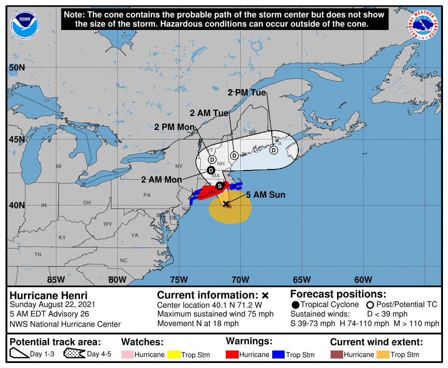
THE LATEST ON HENRI THIS MORNING: The center of recently downgraded Henri is about 140 miles southeast of New York City this morning. The system is over cooler water now and will begin weakening. It has made the northwesterly turn we expected and is slowing its forward speed. The center will make landfall, likely as a strong tropical storm in Rhode Island after passing over Block Island. Tropical storm force gusts will begin over eastern Long Island and southeastern Massachusetts by 7 a.m. CDT or so, with tropical storm force winds spreading eastern Long Island, eastern Connecticut, Rhode Island, and eastern Massachusetts through the day. The system will continue to slow, ending up in Central Massachusetts tonight and drifting into Vermont tomorrow before to the east, meandering along the Maine coast on Tuesday. It should be post-tropical by then.
WHAT HAPPENED TO GRACE: Grace continued to strengthen all the way up to landfall on the Mexican coast around 1 a.m. CDT Saturday morning. It had top winds of 125 mph at landfall, making it a strong category three hurricane.
FOR YOUR SUNDAY: Skies are starting off mostly cloudy across much of Central and North Alabama this morning. A weakening band of showers extends along I-85 in South Central Alabama from Auburn to Montgomery.
Temperatures are in the starting off in the lower and middle 70s. A few widely scattered showers and storms will develop this afternoon. They will dump some heavy rain where they move, but most people will remain dry today. Highs by this afternoon will be in the upper 80s to near 90 degrees. And you can wear the humidity. Lows tonight will be in the 70s.
BLUE MOON: The moon is full at 7:02 a.m. this morning. This full moon is a true Blue Moon by definition, meaning it is the fourth full moon in a quarter.
NEW WORK WEEK: Tomorrow will feature more sunshine and hotter temperatures as the trough that has been passing to our north moves off to the northeast. Highs will be in the lower and middle 90s. Any storms that manage to form will be isolated at best. Tuesday looks hot and dry as well. The ridge producing the heat and dryness will begin to break down a bit as low pressure moves out of the Caribbean and into the Gulf. A lot of moisture will come along with it, at least enough to produce scattered showers and storms by Wednesday, increasing some on Thursday and Friday.
MORE TROPICAL MISCHIEF: On the southern end of the tropical wave, it appears that a tropical cyclone will form over the western Caribbean by late in the week. It appears that it will move toward the Yucatan and into the Bay of Campeche where it will make landfall over northeastern Mexico by Monday the 30th.
NEXT WEEKEND: Scattered showers and storms will impact the state Saturday and Sunday with hot and humid conditions prevailing.
LABOR DAY WEEKEND: Fairly typical end of summer weather for Alabama with scattered showers and storms and hot and humid conditions. Highs will be near 90F. Lows will be in the lower 70s.
BEACHCAST: Rip currents have been an issue along the beautiful beaches of Alabama and Northwest Florida, but things should be calming down today. Seas will still be running around 2 feet. Mostly sunny to partly cloudy skies for much of the week ahead with a chance of a daily storm. Highs will be in the upper 80s to near 90F. Lows will be in the upper 70s to near 80F.
Click here to see the Beach Forecast Center page.
NATIONALLY; Severe flash flooding struck parts of Middle Tennessee on Saturday. Radar estimates showed that over 16 inches of rain may have fallen in areas just west of Dickson, which is southwest of Nashville. I-40 was closed because of high water and severe flooding was reported in the town of Dickson. 11.28 inches of rain was measured at a home weather station near exit 128 off I-40. 17.02 inches fell in McEwen TN. If that verifies, it will be the 24-hour rainfall record for the entire state of Tennessee. A flash flood emergency was issued by the NWS Nashville and the pictures from Dickson and Waverly were catastrophic. So far, ten people have died, and 30 are still missing.
DANCING WITH THE STATS: Remember those old Sears DieHard battery commercials where they would go to the nation’s Ice Box, International falls, Minnesota and start cars with no trouble in sub-zero conditions? No problem there with cold temperatures yesterday as the mercury reached 91F, tying the record for the date.
ADVERTISE WITH US: Deliver your message to a highly engaged audience by advertising on the AlabamaWX.com website. The site enjoyed over 29 MILLION page views in the past 12 months. Don’t miss out! We can customize a creative, flexible, and affordable package that will suit your organization’s needs. Contact me, Bill Murray, at (205) 687-0782, and let’s talk.
WEATHERBRAINS: This week, the panel will entertain a trio of storm chasers who are friends. We will hear about how they came together as a team, how they complement each other, and some of their more memorable chases. Check out the show at www.WeatherBrains.com. You can also subscribe on iTunes. You can watch the show live at live.bigbrainsmedia.com or on James’ YouTube Channel You will be able to see the show on the James Spann 24×7 weather channel on cable or directly over the air on the dot 2 feed.
ON THIS DATE IN 2007: Birmingham’s high of 104F was a record for the date and the thirteenth day of triple-digit heat in the Magic City. The 13 days of 100 degree plus temperatures established a new record for any month in Birmingham. The previous mark was 12 set in 1925. Montgomery tied its record streak at fourteen days. It was 107F in Pinson and 108F in Mumford. The 104F at Atlanta was within one degree of their all-time high and set a new record for August. Follow my weather history tweets on Twitter. I am @wxhistorian at Twitter.com.
Category: Alabama's Weather, ALL POSTS, Tropical
About the Author (Author Profile)
Bill Murray is the President of The Weather Factory. He is the site's official weather historian and a weekend forecaster. He also anchors the site's severe weather coverage. Bill Murray is the proud holder of National Weather Association Digital Seal #0001 @wxhistorianSubscribe
If you enjoyed this article, subscribe to receive more just like it.


