10 pm Advisory — Ida Steady in Strength & Now Entering the Gulf of Mexico; Rapid Intensification Expected
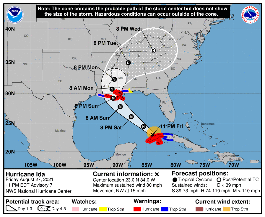
The latest update from the National Hurricane Center shows that the center of Hurricane Ida is now moving back into open waters of the Gulf of Mexico. Rapid Intensification is forecast to occur, and Ida could become a major hurricane as early as Saturday evening. The NHC is projecting maximum sustained winds could reach 140 mph before landfall on the Louisiana coastline by Sunday evening. Here is the latest advisory and forecast…
SUMMARY OF 10 PM CDT INFORMATION
LOCATION…23.0N 84.0W
ABOUT 105 MI…165 KM W OF HAVANA, CUBA
ABOUT 615 MI…985 KM SE OF NEW ORLEANS, LOUISIANA
MAXIMUM SUSTAINED WINDS…80 MPH…130 KM/H
PRESENT MOVEMENT…NW OR 320 DEGREES AT 15 MPH…24 KM/H
MINIMUM CENTRAL PRESSURE…989 MB…29.21 INCHES
WATCHES AND WARNINGS
A Storm Surge Warning is in effect for…
* East of Rockefeller Wildlife Refuge, Louisiana to the Mississippi/Alabama border
* Vermilion Bay, Lake Borgne, Lake Pontchartrain, and Lake Maurepas
A Hurricane Warning is in effect for…
* Cuban provinces of Pinar del Rio and Artemisa, and the Isle of Youth
* Intracoastal City, Louisiana, to the Mouth of the Pearl River
* Lake Pontchartrain, Lake Maurepas, and Metropolitan New Orleans
A Storm Surge Watch is in effect for…
* Sabine Pass to Rockefeller Wildlife Refuge, Louisiana
* Mobile Bay
A Hurricane Watch is in effect for…
* Cameron Louisiana to west of Intracoastal City, Louisiana
* Mouth of the Pearl River to the Mississippi/Alabama border
A Tropical Storm Warning is in effect for…
* Cuban provinces of Matanzas, Mayabeque, and Havana
* Cameron Louisiana to west of Intracoastal City, Louisiana
* Mouth of the Pearl River to the Mississippi/Alabama border
A Tropical Storm Watch is in effect for…
* Mississippi/Alabama border to the Alabama/Florida border
FORECAST DISCUSSION
At 1100 PM EDT (0300 UTC), the center of Hurricane Ida was located near latitude 23.0 North, longitude 84.0 West. Ida is moving toward the northwest near 15 mph (24 km/h) and this general motion should continue until Ida reaches the northern Gulf coast on Sunday. A slower northward motion is forecast after Ida moves inland. On the forecast track, the center of Ida will move over the southeastern and central Gulf of Mexico during the next day or two and make landfall along the U.S. northern Gulf coast within the hurricane warning area by late Sunday.
Maximum sustained winds are near 80 mph (130 km/h) with higher gusts. Rapid strengthening is forecast during the next day or two, and Ida is expected to be an extremely dangerous major hurricane when it approaches the northern Gulf coast on Sunday.
Hurricane-force winds extend outward up to 25 miles (35 km) from the center, and tropical-storm-force winds extend outward up to 115 miles (185 km). The estimated minimum central pressure based on data from the Air Force Hurricane Hunters is 989 mb (29.21 inches).
KEY MESSAGES
1. Life-threatening storm surge and hurricane conditions are expected to continue for the next few hours in portions of western Cuba, including the Isle of Youth, where a Hurricane Warning is in effect. Life-threatening heavy rains, flash flooding and mudslides are expected across Jamaica, the Cayman Islands, and western Cuba, including the Isle of Youth.
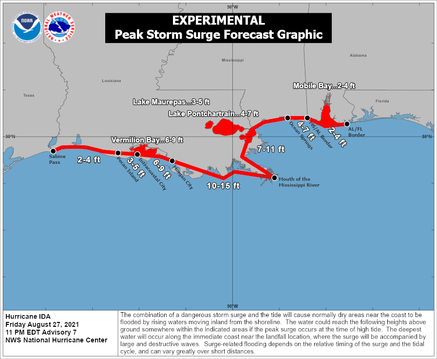
2. There is a danger of life-threatening storm surge inundation Sunday along the coasts of Louisiana and Mississippi within the Storm Surge Warning area. Extremely life-threatening inundation of 10 to 15 feet above ground level is possible within the area from Morgan City, Louisiana, to the Mouth of the Mississippi River. Interests throughout the warning area should follow any advice given by local officials.
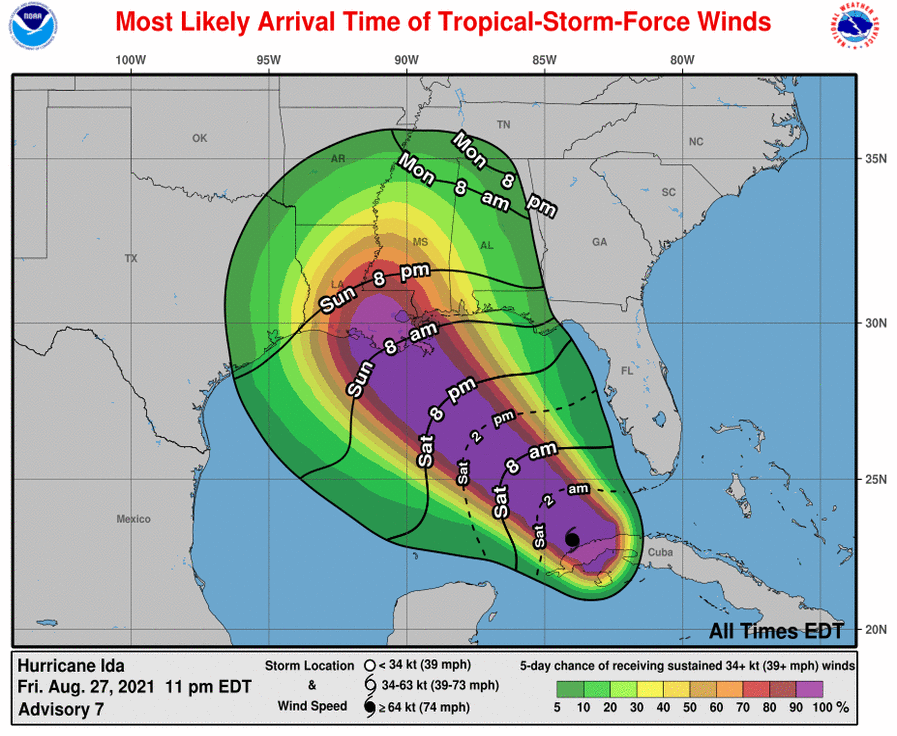
3. Ida is expected to be an extremely dangerous major hurricane when it reaches the coast of Louisiana. Hurricane-force winds are expected Sunday in portions of the Hurricane Warning area along the Louisiana coast, including metropolitan New Orleans, with potentially catastrophic wind damage possible where the core of Ida moves onshore. Actions to protect life and property should be rushed to completion in the warning area.
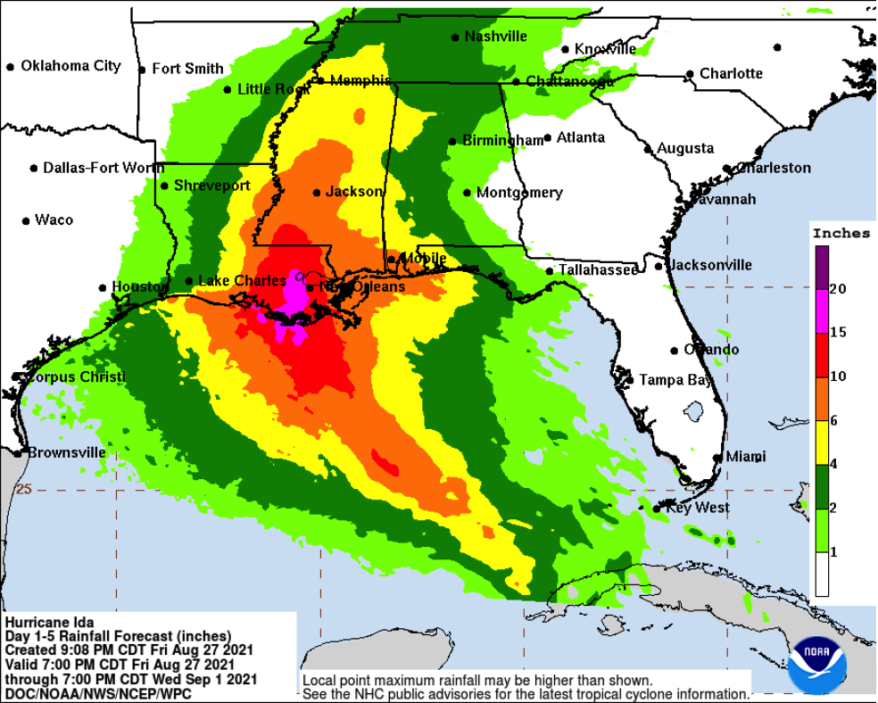
4. Ida is likely to produce heavy rainfall later Sunday into Monday across the central Gulf Coast from southeast Louisiana to coastal Mississippi and Alabama, resulting in considerable flash, urban, small stream, and riverine flooding impacts. As Ida moves inland, flooding impacts are possible across portions of the Lower Mississippi and Tennessee Valleys.
All images, forecasts, and documents are courtesy of their respective publishers.
Category: Alabama's Weather, ALL POSTS, Severe Weather, Tropical
About the Author (Author Profile)
Scott Martin is an operational meteorologist, professional graphic artist, musician, husband, and father. Not only is Scott a member of the National Weather Association, but he is also the Central Alabama Chapter of the NWA president. Scott is also the co-founder of Racecast Weather, which provides forecasts for many racing series across the USA. He also supplies forecasts for the BassMaster Elite Series events including the BassMaster Classic.Subscribe
If you enjoyed this article, subscribe to receive more just like it.


