10 pm Advisory — Ida Now Starting the Northward Turn
SUMMARY OF 1000 PM CDT…0300 UTC…INFORMATION
———————————————–
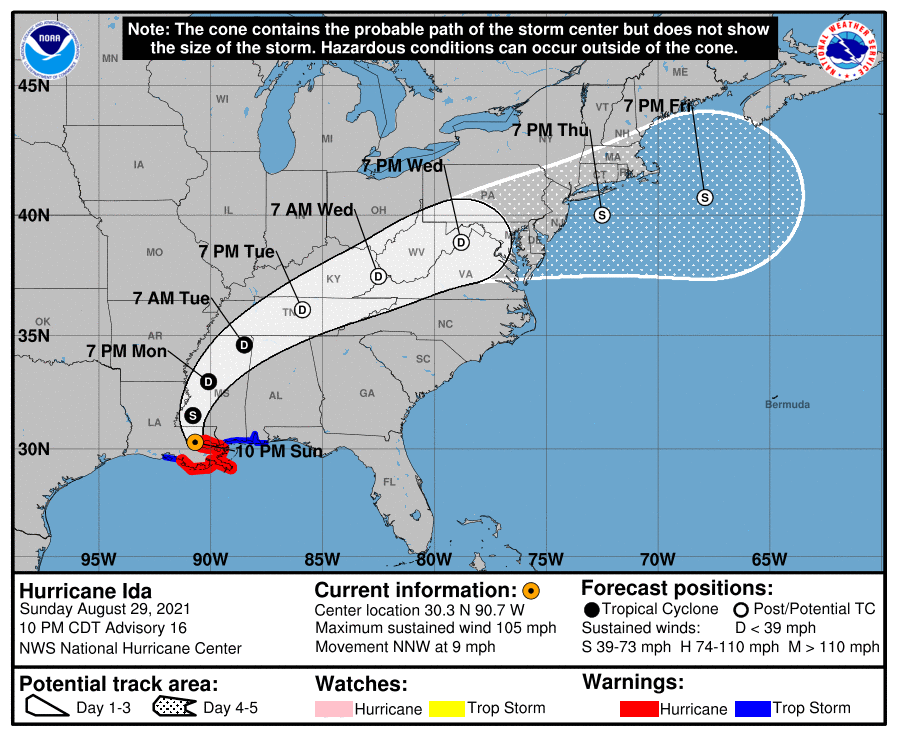
LOCATION…30.3N 90.7W
ABOUT 30 MI…50 KM ESE OF BATON ROUGE, LOUISIANA
ABOUT 40 MI…65 KM WNW OF NEW ORLEANS, LOUISIANA
MAXIMUM SUSTAINED WINDS…105 MPH…165 KM/H
PRESENT MOVEMENT…NNW OR 340 DEGREES AT 9 MPH…15 KM/H
MINIMUM CENTRAL PRESSURE…953 MB…28.15 INCHES
WATCHES AND WARNINGS
——————–
A Storm Surge Warning is in effect for…
* Morgan City, Louisiana, to the Alabama/Florida border
* Lake Borgne, Lake Pontchartrain, Lake Maurepas, and Mobile Bay
A Hurricane Warning is in effect for…
* Morgan City, Louisiana, to the Mouth of the Pearl River
* Lake Pontchartrain, Lake Maurepas, and Metropolitan New Orleans
A Tropical Storm Warning is in effect for…
* Intracoastal City, Louisiana to the west of Morgan City, Louisiana
* Mouth of the Pearl River to the Alabama/Florida border
DISCUSSION AND OUTLOOK
———————-
At 1000 PM CDT (0300 UTC), the center of Hurricane Ida was located near latitude 30.3 North, longitude 90.7 West. Ida is moving toward the north-northwest near 9 mph (15 km/h). A turn toward the north is expected overnight, followed by a slightly faster northeastward motion by Monday night and Tuesday. On the forecast track, the center of Ida will move farther inland over southeastern Louisiana tonight. Ida is then forecast to move well inland over portions of western Mississippi Monday and Monday night, and move across the Tennessee Valley on Tuesday.
Maximum sustained winds are near 105 mph (165 km/h) with higher gusts. Rapid weakening is expected during the next day or so, however, Ida is expected to remain a hurricane for several more hours.
Hurricane-force winds extend outward up to 35 miles (55 km) from the center, and tropical-storm-force winds extend outward up to 140 miles (220 km). A sustained wind of 64 mph (104 km/h) and a wind gust of 90 mph (145 km/h) were reported recently reported at the New Orleans International Airport.
The estimated minimum central pressure is 953 mb (28.15 inches).
HAZARDS AFFECTING LAND
———————-
STORM SURGE: The combination of a dangerous storm surge and the tide will cause normally dry areas near the coast to be flooded by rising waters moving inland from the shoreline. The water could reach the following heights above ground somewhere in the indicated areas if the peak surge occurs at the time of high tide…
* Morgan City, LA to Bay St. Louis, MS including Lake Borgne…7-11 ft
* Lake Pontchartrain…5-8 ft
* Bay St. Louis, MS to Ocean Springs, MS…4-7 ft
* Lake Maurepas…4-6 ft
* Ocean Springs to AL/FL border including Mobile Bay…3-5 ft
* Intracoastal City, LA to Morgan City, LA including Vermilion Bay…1-3 ft
* AL/FL border to Okaloosa/Walton County Line including Pensacola Bay…1-3 ft
Overtopping of local levees outside of the Hurricane and Storm Damage Risk Reduction System is possible where local inundation values may be higher than those shown above.
The deepest water will occur along the immediate coast near and to the east of the landfall location, where the surge will be accompanied by large and dangerous waves. Surge-related flooding depends on the relative timing of the surge and the tidal cycle, and can vary greatly over short distances. For information specific to your area, please see products issued by your local National Weather Service forecast office.
WIND: Wind damage is likely near the core of Ida as it moves farther inland over southeastern Louisiana during the next few hours.
Hurricane conditions will spread farther inland within the Hurricane Warning area over southeastern Louisiana for the next few hours. Tropical storm conditions will also spread inland over portions of Louisiana and Mississippi through Monday.
RAINFALL: Heavy rainfall from Ida will continue to impact the southeast Louisiana coast, spreading northeast into the Lower Mississippi Valley this evening into Monday. Total rainfall accumulations of 10 to 18 inches, with isolated maximum amounts of 24 inches, are possible across southeast Louisiana into far southern Mississippi through Monday. This is likely to result in life-threatening flash and urban flooding and significant river flooding impacts.
Ida is forecast to turn to the northeast on Monday and track across the Middle Tennessee Valley and Upper Ohio Valley through Wednesday, producing the following rainfall totals:
Coastal Alabama to the far western Florida panhandle: 5 to 10 inches, with isolated maximum amounts of 15 inches, today through Tuesday morning.
Central Mississippi: 4 to 8 inches, with isolated maximum amounts of 12 inches, tonight through Monday night.
Middle Tennessee Valley, Upper Ohio Valley, Central Appalachians into the Mid-Atlantic: 3 to 6 inches with isolated higher amounts, Tuesday into Wednesday.
These rainfall totals will result in considerable flash flooding, along with widespread minor to isolated major riverine flooding from the Lower Mississippi Valley into far western Alabama.
TORNADOES: Tornadoes will be most likely through Monday over southeast Louisiana, southern Mississippi, southwest Alabama, and the western Florida Panhandle. A few tornadoes are also possible farther north across much of Mississippi and Alabama on Monday.
SURF: Swells will continue to affect the northern Gulf coast through Monday. These swells are likely to cause life-threatening surf and rip current conditions. Please consult products from your local weather office.
Category: Alabama's Weather, ALL POSTS, Severe Weather, Tropical
About the Author (Author Profile)
Scott Martin is an operational meteorologist, professional graphic artist, musician, husband, and father. Not only is Scott a member of the National Weather Association, but he is also the Central Alabama Chapter of the NWA president. Scott is also the co-founder of Racecast Weather, which provides forecasts for many racing series across the USA. He also supplies forecasts for the BassMaster Elite Series events including the BassMaster Classic.Subscribe
If you enjoyed this article, subscribe to receive more just like it.


