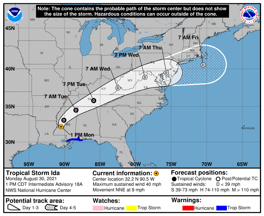
1 pm Advisory — Ida Moving North-Northeastward Over Western Mississippi
SUMMARY OF 100 PM CDT…1800 UTC…INFORMATION
———————————————-
LOCATION…32.2N 90.5W
ABOUT 20 MI…30 KM WSW OF JACKSON, MISSISSIPPI
MAXIMUM SUSTAINED WINDS…40 MPH…65 KM/H
PRESENT MOVEMENT…NNE OR 15 DEGREES AT 9 MPH…15 KM/H
MINIMUM CENTRAL PRESSURE…997 MB…29.45 INCHES
WATCHES AND WARNINGS
——————–
A Storm Surge Warning is in effect for…
* Mouth of the Pearl River to the Alabama/Florida border
A Tropical Storm Warning is in effect for…
* Mouth of the Pearl River to the Alabama/Florida border
DISCUSSION AND OUTLOOK
———————-
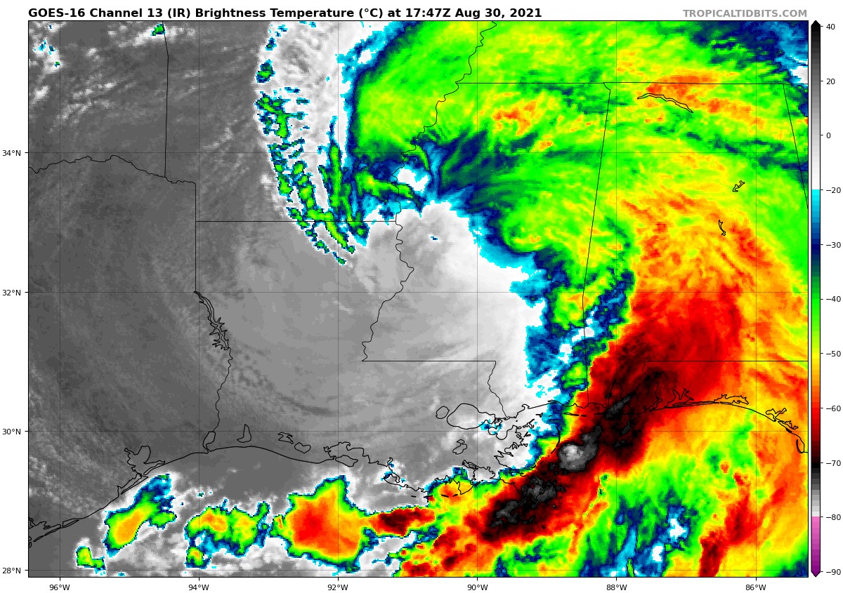
At 100 PM CDT (1800 UTC), the center of Tropical Storm Ida was located near latitude 32.2 North, longitude 90.5 West. Ida is moving toward the north-northeast near 9 mph (15 km/h), and this general motion is forecast to continue today. A faster northeastward motion is expected to begin by tonight and continue through Tuesday night. On the forecast track, the center of Ida will move farther inland over western and central Mississippi this afternoon. Ida is then forecast to move over northeastern Mississippi tonight, and move across the Tennessee Valley on Tuesday and near the central Appalachians on Wednesday.
Maximum sustained winds are near 40 mph (65 km/h) with higher gusts. Weakening is forecast during the next day or so, and Ida is expected to become a tropical depression later this afternoon. Tropical-storm-force winds extend outward up to 195 miles (315 km) mainly to the southeast of the center over water.
The estimated minimum central pressure from surface observations is 997 mb (29.45 inches).
HAZARDS AFFECTING LAND
———————-
STORM SURGE: The combination of a dangerous storm surge and the tide will cause normally dry areas near the coast to be flooded by rising waters moving inland from the shoreline. The water could reach the following heights above ground somewhere in the indicated areas if the peak surge occurs at the time of high tide…
Mouth of the Pearl River to AL/FL border, including Mobile Bay…2-4 ft
Morgan City, LA to the Mouth of the Pearl River including Lake Borgne…1-3 ft
Lake Maurepas and Lake Pontchartrain…1-3 ft
AL/FL border to Okaloosa/Walton County Line, including Pensacola Bay…1-3 ft
Surge-related flooding depends on the relative timing of the surge and the tidal cycle, and can vary greatly over short distances. For information specific to your area, please see products issued by your local National Weather Service forecast office.
WIND: Tropical storm conditions will continue over portions of southern Mississippi and southern Alabama through this afternoon.
RAINFALL: Through Tuesday morning across portions of southeast Louisiana into far southern Mississippi, Ida will produce additional rainfall totals of 2 to 4 inches, with localized higher amounts possible. Storm total rainfall accumulations of 10 to 18 inches, with isolated maximum amounts of 24 inches, are expected. Heavy rain combined with storm surge has resulted in catastrophic impacts along the southeast coast of Louisiana, with considerable flash flooding and riverine flooding continuing farther inland.
Ida will continue to turn northeast this morning and is forecast to track across the Middle Tennessee Valley, Ohio Valley and Mid-Atlantic through Wednesday, producing the following rainfall totals:
Coastal Alabama to the far western Florida panhandle: An additional 4 to 8 inches resulting in storm total accumulations of 6 to 12 inches with isolated maximum amounts of 15 inches, today through Tuesday morning.
Central Mississippi into far western Alabama: 4 to 8 inches, with isolated maximum amounts of 12 inches, today through tonight.
Middle Tennessee Valley, Ohio Valley, Central/Southern Appalachians into the Mid-Atlantic: 3 to 6 inches with isolated higher amounts, Tuesday into Wednesday.
Considerable flash flooding is possible from the Lower Mississippi Valley through the Middle Tennessee Valley, Ohio Valley, Central/Southern Appalachians, and into the Mid-Atlantic. Widespread minor to isolated major riverine flooding is occurring or forecast from the Lower Mississippi Valley into far western Alabama. Rivers will remain elevated into next week.
TORNADOES: A few tornadoes are possible through tonight, mainly across southeast Mississippi, southern Alabama, and the western Florida Panhandle. The threat for a few tornadoes will shift east on Tuesday and become centered across eastern Alabama, western Georgia, and the Florida Panhandle.
SURF: Swells will continue to affect portions of the northern Gulf coast through today. These swells are likely to cause life-threatening surf and rip current conditions.
Category: Alabama's Weather, ALL POSTS, Severe Weather, Tropical
About the Author (Author Profile)
Scott Martin is an operational meteorologist, professional graphic artist, musician, husband, and father. Not only is Scott a member of the National Weather Association, but he is also the Central Alabama Chapter of the NWA president. Scott is also the co-founder of Racecast Weather, which provides forecasts for many racing series across the USA. He also supplies forecasts for the BassMaster Elite Series events including the BassMaster Classic.Subscribe
If you enjoyed this article, subscribe to receive more just like it.


