The Midday Check on Central Alabama’s Weather
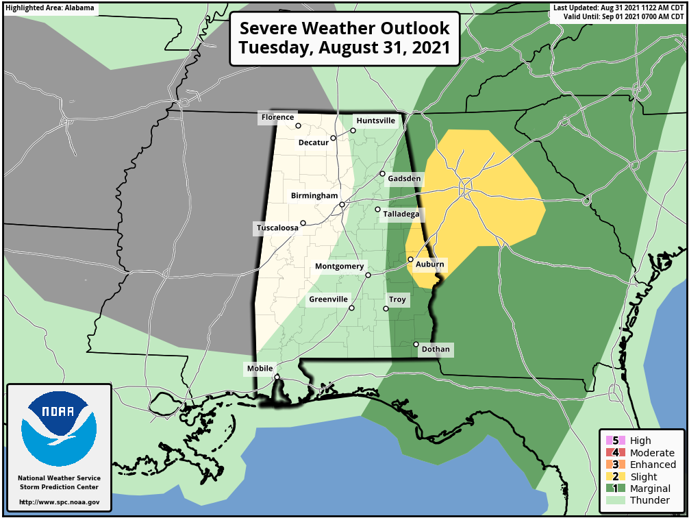
At midday, the good news is that the threat for any tornadoes from the remnants of Ida is starting to quickly fade as most of the activity has shifted over into Georgia. The Storm Prediction Center now only has a very small portion of the east and southern parts of Central Alabama in a Slight Risk, with the Marginal Risk being confined more to the extreme eastern parts of the area.
• Slight Risk: locations along and east of a line from Woodland to Loachapoka to Hurtsboro.
• Marginal Risk: locations along and west of a line from Fort Payne to Anniston to Troy.
The threat for those locations will continue from now through 4 pm.
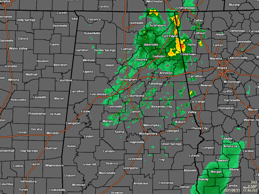
While the heavier shower activity is pushing into Georgia from the northeastern parts of the area, we’ll continue to have light to moderate showers throughout much of the area through the rest of the daylight hours. Today’s highs will be in the mid 70s to the mid 80s. For tonight, rain will continue to decrease from west to east, but skies will remain mostly cloudy after the rain leaves your area. Lows will be in the upper 60s to the lower 70s.
While it will be breezy at times, the winds will now stay below advisory levels, and the Wind Advisory for Central Alabama has been canceled. The threat of flooding issues have also ended, and the Flash Flood Watch has been canceled for Central Alabama as well. NWS Huntsville continues the Flash Flood Watch for DeKalb, Jackson, Madison, and Marshall counties in North Alabama until 1 am Wednesday, while canceling the watch for Colbert, Cullman, Franklin, Lauderdale, Lawrence, Limestone, and Morgan counties.
Speaking of Wednesday, we’ll have a mix of sun and clouds, with only a small chance of a few isolated to scattered showers and maybe a few claps of thunder. Highs will be in the 80s across the area.
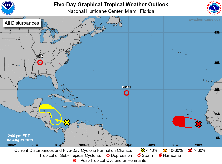
Kate has been downgraded to a tropical depression, with the center located around 840 miles to the northeast of the Leeward Islands. Maximum sustained winds were at 35 mph and was moving to the north around 5 mph. This general motion should continue through today. A north-northwestward motion is forecast to begin tonight and continue through Thursday. Little change in strength is forecast during the next few days.
Showers and thunderstorms have become better organized in association with a well-defined low pressure system located over the far eastern tropical Atlantic, a few hundred miles west of the coast of Guinea. If these development trends continue, a tropical depression is likely to form later today or tonight, while the system moves westward to west-northwestward at around 20 mph across the eastern tropical Atlantic.
* Formation chance through 48 hours … high … 90 percent.
* Formation chance through 5 days … high … 90 percent.
A broad area of low pressure is producing some disorganized shower activity over the southwestern Caribbean Sea. Some slow development of this system is possible over the next couple of days as it moves westward or west-northwestward at 5 to 10 mph toward Central America. Thereafter, land interaction with Central America and the Yucatán Peninsula of Mexico will likely limit further development of this system.
* Formation chance through 48 hours … low … 10 percent.
* Formation chance through 5 days … low … 20 percent.
Category: Alabama's Weather, ALL POSTS, Severe Weather, Tropical
About the Author (Author Profile)
Scott Martin is an operational meteorologist, professional graphic artist, musician, husband, and father. Not only is Scott a member of the National Weather Association, but he is also the Central Alabama Chapter of the NWA president. Scott is also the co-founder of Racecast Weather, which provides forecasts for many racing series across the USA. He also supplies forecasts for the BassMaster Elite Series events including the BassMaster Classic.Subscribe
If you enjoyed this article, subscribe to receive more just like it.


