Sunday Weather Xtreme Video: Late Summer Warmth for Alabama; Could See Nicholas in the Gulf This Week
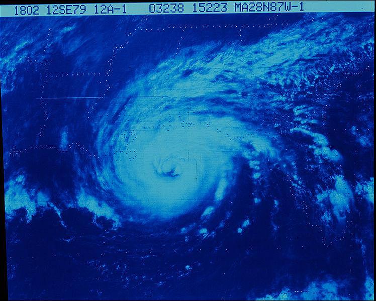
Major Hurricane Frederic approaching the Gulf Coast on this date in 1979
42 years ago today, Alabama and the Gulf Coast were bracing for impact from Hurricane Frederic, which would make landfall on the evening of September 12, 1979, near the Alabama/Mississippi border with maximum sustained winds of 130 mph. Winds gusted to 145 on the Dauphin Island Bridge, which was destroyed. A surge of 12-15 was felt along the Gulf beaches of Mobile and Baldwin Counties, with 8-19 feet at the north end of Mobile Bay. Wind damage was extensive, with parts of Mobile County remaining without power for up to five weeks.
GULF DISTURBANCE: We continue to keep an eye on a disturbance over the southwestern Gulf of Mexico. The Hurricane Hunters are going down to take a look-see today. Conditions are becoming more favorable for development, and a tropical depression could form today or tomorrow. The prospects for eventual development are contingent on the system’s expected northward turn. If that turn does not materialize sooner than later, the system may run out of the ocean and disintegrate over Mexico. But if it can remain over water, it could develop into something more significant and be a problem for Texas or Louisiana. The global models have been in good agreement that a path toward the Central Texas coast is likely. The guidance is not too excited about the storm gaining very much intensity, with only a couple of models even predicting tropical storm intensity. We will be watching.
EXTREME RAINFALL FOR SOUTHERN LOUISIANA? One thing we will be watching is for very heavy rain amounts over southwestern and southern Louisiana by late in the week if the Gulf system gets its act together. 10-15 inch amounts are not out of the question.
LOOKING BACK AT SATURDAY: Yesterday was a good weather day for college football games across the state. Skies were mostly sunny with some big, pretty cumulus clouds spaced nicely apart. Afternoon readings were in the lower and middle 80s. Dewpoints were in the lower 60s, not crisp by any means, but not pushing 70F like they do most of the summer here in the state.
FOR YOUR SUNDAY: Moisture levels have been slowly rising across Alabama over the past couple of days. That trend will continue today. But like yesterday, drier air aloft will keep a lid on shower and storm development. After lows this morning in the 60s, afternoon highs will top out around 90F.
NEW WORK WEEK: Late summerlike conditions will continue across Alabama, with moisture levels slowly rising. Rain chances will also be on the rise as well. Expect only slight chances Monday, but slowly rising Tuesday and Wednesday. By Thursday, our tropical system may be moving into western Louisiana. This will put us on the eastern side of the cyclone, increasing our moisture and triggering better coverage of showers and storms.
WEEKEND OUTLOOK: A general weakness in the pressure field across the South that will allow the tropical system to move up into Louisiana will begin to disappear by late in the week, trapping the system to our west, and lowering our rain chances. Temperatures going into the weekend will be in the vicinity of 70F with afternoon readings in the middle 80s. Showers and storms will be scattered through Tuesday, but coverage will increase by midweek as the tropical system moves into Louisiana.
VOODOO COUNTRY: The subtropical ridge seems to hold its position just to our southeast into the week two period, keeping us warm and humid, with scattered afternoon and evening showers and storms, but protecting us from any frontal passages. The GFS does hint that we might see another tropical system coming up into the eastern Gulf of Mexico toward the end of the forecast period, around the 26th.
BEACHCAST: Scattered showers and storms through Tuesday along the beautiful beaches of Alabama and Northwest Florida. Those rain chances will start to increase by midweek, as the tropical system goes inland to the west of the west of our favorite beaches. Lows will be in the middle 70s. Highs will be in the middle 80s. Water temperatures are running in the lower 80s.
Click here to see the Beach Forecast Center page.
ON THE OTHER SIDE OF THE WORLD: Supertyphoon Chantau passed by Taiwan overnight, fortunately weakening as it went. The storm, still sporting winds of 110 mph, is a shadow of its former self. On Friday, the system had top winds of 178 mph, making it a fearsome Category Five typhoon. It underwent rapid intensification
ADVERTISE WITH US: Deliver your message to a highly engaged audience by advertising on the AlabamaWX.com website. The site enjoyed over 29 MILLION page views in the past 12 months. Don’t miss out! We can customize a creative, flexible, and affordable package that will suit your organization’s needs. Contact me, Bill Murray, at (205) 687-0782, and let’s talk.
WEATHERBRAINS: This week, the panel will entertain Michelle Mainelli. Michelle is in charge of the NWS’s dissemination modernization effort. Check out the show at www.WeatherBrains.com. You can also subscribe on iTunes. You can watch the show live at live.bigbrainsmedia.com or on James’ YouTube Channel You will be able to see the show on the James Spann 24×7 weather channel on cable or directly over the air on the dot 2 feed.
ON THIS DATE IN 1977: Twenty-five people were killed in flash flooding that extends over two days (September 12-13) in Kansas City, Missouri as storms dropped 16 inches of rain. A quick six inches of rain in a short time of the saturated Brush Creek caused some of the deadliest flooding. The flooding was the worst in the history of the city. The rains were produced by two groups of thunderstorms, one in the morning and another in the evening. The baseball game between the Royals and A’s was stopped at 7:45 PM because of the intense rainfall. Follow my weather history tweets on Twitter. I am @wxhistorian at Twitter.com.
Category: Alabama's Weather, ALL POSTS, Met 101/Weather History
About the Author (Author Profile)
Bill Murray is the President of The Weather Factory. He is the site's official weather historian and a weekend forecaster. He also anchors the site's severe weather coverage. Bill Murray is the proud holder of National Weather Association Digital Seal #0001 @wxhistorianSubscribe
If you enjoyed this article, subscribe to receive more just like it.


