Sunday Weather Xtreme Video: More Heavy Rain Possible Today
Saturday’s persistent rains brought flash flooding to parts of North and Central Alabama. Upwards of 4 inches of rain fell in some areas. Rainfall rates exceeded two inches per hour in some locations. I picked up one-half inch of rain in just five minutes off Acton Road in Vestavia. Fortunately, the rain rate decreased for us, or bigger problems might have occurred here. Numerous flood advisories and flash flood warnings were required across the state.
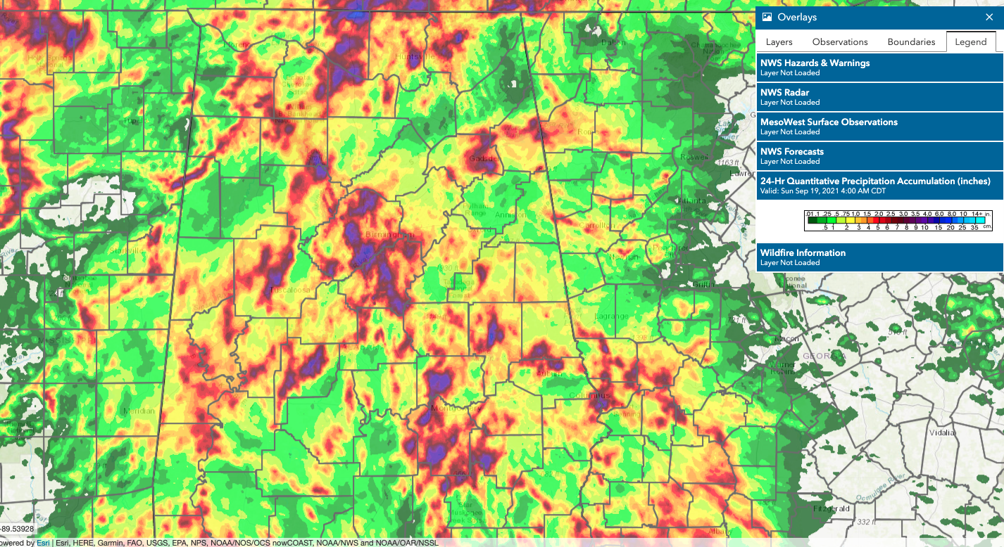
SAME ATMOSPHERE TODAY: A very moist, tropical airmass continues across Alabama early on this Sunday morning. Precipitable water values are through the roof again, pushing 2.25 inches across the area, which is near record territory for mid-September. That’s a sure sign of very heavy rain. And the trough to the west continues to transport warm, moist air into the region. Widespread showers and storms are already forming this morning in the tropical environment. The will lift slowly north through the morning and afternoon. The slow motion will help to exacerbate those rainfall rates and totals. And with saturated soils, all that water has no place to go.
AS A RESULT: A Flash Flood Watch continues for most of North and Central Alabama until early this evening. The NWS Birmingham actually removed a few counties over southwestern portions of Central Alabama early this morning but added a few counties over its southeastern area of responsibility. Have a plan in case you live in a flood-prone area and be alert for persistent heavy rainfall, taking any precautions you would take in case waters rise. Remember what we always say, “Turn around, Don’t drown.”
NEW WORK WEEK: Rinse and repeat for Monday and Tuesday. With each exceeding wave of rainfall, a flooding threat will ensue. Remain alert to that possibility. Highs both days will be in the lower 80s. Lows will be near 70F.
FALL ARRIVES: The autumnal equinox will occur on Wednesday at 2:20 p.m. CDT. About that same, a decent cold front will be knifing through Northwest Alabama. As long as the trough driving the front doesn’t cut off into an upper level low, the rain should come to an end and cooler temperatures will arrive. Lows Thursday morning will be in the 50s across the northern two-thirds of the state.
FINE FALL LIKE FARE: Is in store for the late week into the weekend period. Expect brilliantly sunny skies and comfortable temperatures will prevail through Sunday. Highs will be in the 70s. Lows will be in the 50s.
VOODOO TERRITORY: It looks like the upcoming run of fall-like conditions will be with us through the end of the month and into early October. Sounds good.
GOODBYE ODETTE: The NHC wrote the last advisory on Post Tropical Cyclone Odette, about 300 miles south of Newfoundland. The remnant storm will wander around the North Atlantic the rest of the week.
HELLO PETER: We have two new tropical cyclones on the board early this morning, and it appears that neither poses a threat to the United States mainland. Tropical Storm Peter formed late last night and is located about 825 miles east southeast of San Juan, Puerto Rico this morning. Top winds are 40 mph and the central pressure is estimated to be 1005 millibars. And Tropical Depression 17 has just been designated in the far eastern Atlantic, southwest of the Cabo Verde Islands, west of the African coast. Peter is expected to northwestward, remaining north of the islands of the Antilles and never really developing very much. Max forecast winds are 45 mph. It could pose a threat to Bermuda by next weekend as it begins to recurve out to sea. There is some small chance that it could get forced back to the west to affect the United States East Coast, but that is not expected to happen for now. TD 17 will travel northwestward as well over open water, passing well west of the Cabo Verde Islands and into the Central Atlantic. It is expected to become Tropical Storm Rose later today. It poses no threat to any land areas.
GULF COAST WEATHER: High chances of rain and storms will plague the beautiful beaches of Alabama and Northwest Florida through Tuesday, with the same front bringing fall-like weather to North and Central Alabama also improving conditions along the coast. Highs will be in the 80s through the period. Lows that are in the middle 70s through Tuesday will drop back into the 60s for the end of the week. Water temperatures are running in the lower 80s. Not much of a rip current risk over the next three days along the beaches.
DANCING WITH THE STATS: 101F at Roswell NM yesterday was a record for the date.
ADVERTISE WITH US: Deliver your message to a highly engaged audience by advertising on the AlabamaWX.com website. The site enjoyed over 29 MILLION page views in the past 12 months. Don’t miss out! We can customize a creative, flexible, and affordable package that will suit your organization’s needs. Contact me, Bill Murray, at (205) 687-0782, and let’s talk.
WEATHERBRAINS: We will be covering the latest developments in weather radar with experts from the National Severe Storms Laboratory on the show Monday night. Check out the show at www.WeatherBrains.com. You can also subscribe on iTunes. You can watch the show live at: http://live.bigbrainsmedia.com/ You will be able to see the show on the James Spann 24×7 weather channel on cable or directly over the air on the dot 2 feed.
ON THIS DATE IN 1926: The 1926 Hurricane devastated Miami during the early morning hours of September 18th. Fifty miles west of Miami the residents around Lake Okeechobee were worried. The Lake was at a very high level after a summer of heavy rains. Through the night of the 17th, men worked to shore up the mud dike around the southern end of the Lake. As the hurricane passed south of the Lake during the morning hours, easterly winds of up to 100 mph piled water up against the western end of the Lake around the town of Moore Haven. Waves crashed over the four-foot-high mud dike, weakening the levee. The dike collapsed in several places, sending water over the first floor of most homes and buildings. 250 people died around the Lake. The disaster would be a prelude of an even greater disaster to come two years later. Follow my weather history tweets on Twitter. I am @wxhistorian at Twitter.com.
Category: Alabama's Weather, ALL POSTS, Tropical
About the Author (Author Profile)
Bill Murray is the President of The Weather Factory. He is the site's official weather historian and a weekend forecaster. He also anchors the site's severe weather coverage. Bill Murray is the proud holder of National Weather Association Digital Seal #0001 @wxhistorianSubscribe
If you enjoyed this article, subscribe to receive more just like it.


