

Midday Nowcast: Fantastic Fall Friday
After the chilly start to the day, we are enjoying yet another amazing autumn day of weather across all of Alabama. The sky is full if sunshine, humidity levels remain low, and temperatures this afternoon are in the mid to upper 70s, which remain below average for this time of year. Tonight will be another refreshing one with a clear sky lows will fall into the 50s for most locations, with some 40s in the colder spots.
FRIDAY NIGHT LIGHTS: Perfect weather for the high school games across Alabama tonight; clear and cool with temperatures falling through the 60s.
WONDERFUL WEEKEND WEATHER: Gorgeous weather will continue to highlight our forecast for the weekend with low humidity, tons of sunshine, and comfortable temperatures. Now highs will moderate some as lower 80s return, but nights will remain quite nice with 50s.
FOOTBALL FORECAST: GEORGIA STATE AT AUBURN (3p CT kickoff at Jordan-Hare Stadium): A clear sky with temperatures falling from near 80 degrees at kickoff into the low 70s by the final whistle.
SOUTHERN MISS AT ALABAMA (6:30p CT kickoff at Bryant-Denny Stadium): Clear and very pleasant. Kickoff temperature near 78 degrees, falling into the upper 60s by the fourth quarter.
UAB AT TULANE (7p CT kickoff at Yulman Stadium in New Orleans): A clear sky with temperatures falling from 77 degrees at kickoff to near 70 by the final whistle.
UT-MARTIN AT JACKSONVILLE STATE (3p CT kickoff at Burgess-Snow Field): A beautiful day; the sky will be clear with temperatures falling from 79 degrees at kickoff to near 70 by the end of the game.
TROY AT LA-MONROE (7p CT kickoff at Monroe, LA): The sky will be clear with temperatures falling from near 80 at kickoff, into the upper 60s by the final whistle.
TYPICAL FALL WEATHER: As we roll into next week, the dry weather will continue, but temperatures will continue to moderate some as mid-80s highlight our forecast for afternoon highs, which are pretty close to seasonal average for the final days of September. Lows will be in the 60s most nights, but again with humidity levels remaining low, the weather will be pretty nice. As far as rain, the long range models show no threat for widespread rain for Alabama until at least October.
IN THE TROPICS: The National Hurricane Center is issuing advisories on recently upgraded Hurricane Sam, located about 1400 miles east-southeast of the northern Leeward Islands.
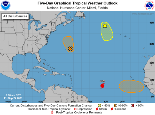
1. A large area of showers and thunderstorms centered a couple hundred miles east of Bermuda is associated with a formative surface low interacting with an upper-level trough. Additional tropical or subtropical development of this system could occur through early Saturday as it moves generally north-northwestward. After that time, development is not expected due to strong upper-level winds. Formation chance through 5 days…medium…40 percent.
2. A gale-force, non-tropical low pressure system, the remnants of Odette, is located a little less than 600 miles west-northwest of the westernmost Azores. Showers and thunderstorms remain limited near the low, and the window of opportunity for this system to become a subtropical or tropical cyclone is closing as strong upper-level winds are expected to develop over the system later today. This system will move generally south-southeastward over the next day or two. Formation chance through 5 days…low…20 percent.
3. A tropical wave is expected to move off the west coast of Africa by the end of this weekend. Thereafter, environmental conditions are forecast to be conducive for gradual development, and a tropical depression could form by the middle of next week while the system moves westward at 10 to 15 mph over the far eastern tropical Atlantic. Formation chance through 5 days…medium…40 percent.
HURRICANE SAM: The center of Hurricane Sam was located near latitude 11.8 North, longitude 43.7 West. Sam is moving just north of due west near 14 mph and this motion is expected to continue through tonight. A decrease in forward speed and a motion toward the west-northwest are expected over the weekend.
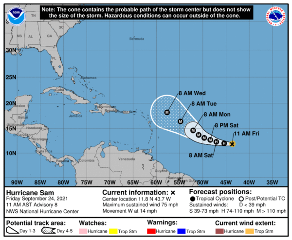
Maximum sustained winds remain near 75 mph with higher gusts. Rapid intensification is forecast to resume over the next several days and Sam is likely to become a major hurricane on Saturday. Hurricane-force winds extend outward up to 15 miles from the center and tropical-storm-force winds extend outward up to 60 miles. The estimated minimum central pressure is 993 mb (29.33 inches).
BEACH FORECAST CENTER: Get the latest weather and rip current forecasts for the beaches from Fort Morgan to Panama City on our Beach Forecast Center page. There, you can select the forecast of the region that you are interested in visiting.
WORLD TEMPERATURE EXTREMES: Over the last 24 hours, the highest observation outside the U.S. was 113.7F at Abadan, Iran. The lowest observation was -104.3F at Vostok, Antarctica.
CONTIGUOUS TEMPERATURE EXTREMES: Over the last 24 hours, the highest observation was 108F at Death Valley, CA. The lowest observation was 19F at Peter Sinks, UT.
WEATHER ON THIS DATE IN 1926: The temperature at Yellowstone Park dipped to nine degrees below zero. It was the coldest reading of record in the U.S. during September. Severe freezes were widespread over the northwestern U.S. causing great crop destruction. In Washington State, Spokane County experienced their earliest snow of record. Harney Branch Experiment Station in Oregon reported a temperature of 2 degrees above zero to establish a state record for the month of September.
Category: Alabama's Weather, ALL POSTS
About the Author (Author Profile)
Macon, Georgia Television Chief Meteorologist, Birmingham native, and long time Contributor on AlabamaWX. Stormchaser. I did not choose Weather, it chose Me. College Football Fanatic. @Ryan_StinnetSubscribe
If you enjoyed this article, subscribe to receive more just like it.


