4 p.m. Update on Hurricane Sam: Top Winds 150 mph, Now Tied with Ida as Strongest Atlantic Hurricane of Season
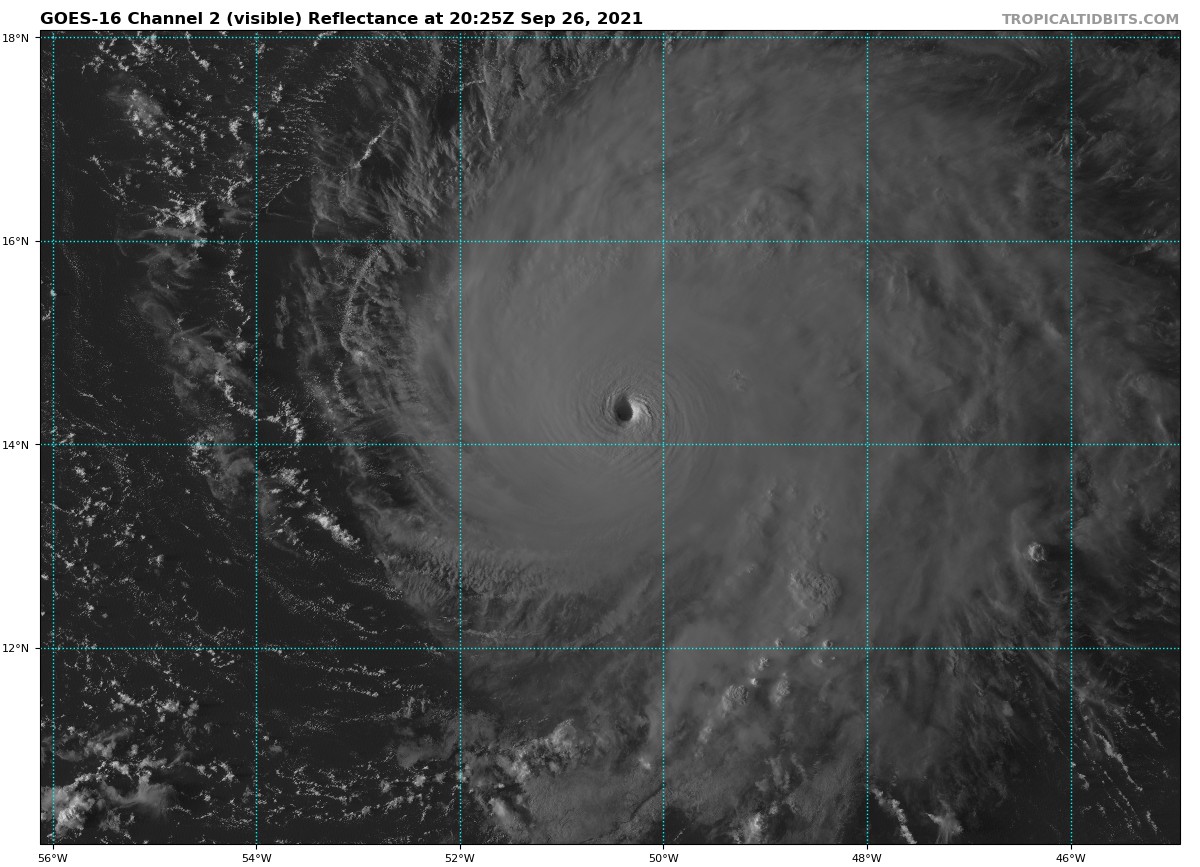
Dramatic visible satellite image at sun sets over Hurricane Sam
We haven’t had any reconnaissance in the store yet today, but the NOAA HUrricane Hunter plan has left St. Croix en route to the storm. But satellite estimates indicate top winds are now 150 mph, making it a top end Category Four hurricane, just 6 mph shy of becoming a Category 5. That is still possible since the storm is over warm water and in an area of light shear.
The center is now located about 770 miles east southeast of the island of Guadaloupe in the Leeward Islands.
It has turned to the northwest now with a forward speed of 7 mph.
It is forecast now to continue turning to the northern and will pass well northeast of the northern Leeward Islands. The closest approach should occur Wednesday night, when the center is expected to be about 325 miles northeast of the islands, putting them out of danger of everything but the large swells from the powerful storm.
The official forecast has the system about 400 miles south southeast of Bermuda by noon on Friday. It is too early to be sure the storm will pass east of the beautiful island nation, but most of the global and hurricane models do keep the center fairly far to the east. But some of the GFS ensemble members are way to close still and at category 3 or 2 strength. We will be watching.
The threat to the U.S. East Coast looks negligible.
Here is the 4 p.m.m Advisory:
BULLETIN
HURRICANE SAM ADVISORY NUMBER 17
NWS NATIONAL HURRICANE CENTER MIAMI FL AL182021
500 PM AST SUN SEP 26 2021
…SMALL BUT FEROCIOUS SAM STRENGTHENS SOME MORE…
…EXPECTED TO REMAIN A MAJOR HURRICANE FOR SEVERAL DAYS
SUMMARY OF 500 PM AST…2100 UTC…INFORMATION
———————————————-
LOCATION…14.2N 50.5W
ABOUT 880 MI…1415 KM ESE OF THE NORTHERN LEEWARD ISLANDS
MAXIMUM SUSTAINED WINDS…150 MPH…240 KM/H
PRESENT MOVEMENT…NW OR 305 DEGREES AT 7 MPH…11 KM/H
MINIMUM CENTRAL PRESSURE…938 MB…27.70 INCHES
WATCHES AND WARNINGS
——————–
THERE ARE NO COASTAL WATCHES OR WARNINGS IN EFFECT.
DISCUSSION AND OUTLOOK
———————-
AT 500 PM AST (2100 UTC), THE CENTER OF HURRICANE SAM WAS LOCATED
NEAR LATITUDE 14.2 NORTH, LONGITUDE 50.5 WEST. SAM IS MOVING TOWARD
THE NORTHWEST NEAR 7 MPH (11 KM/H) AND THIS MOTION IS EXPECTED TO
CONTINUE FOR THE NEXT FEW DAYS, ALONG WITH A GRADUAL INCREASE IN
FORWARD SPEED COMMENCING BY MIDWEEK.
MAXIMUM SUSTAINED WINDS HAVE INCREASED TO NEAR 150 MPH (240 KM/H)
WITH HIGHER GUSTS. SAM IS A CATEGORY 4 HURRICANE ON THE
SAFFIR-SIMPSON HURRICANE WIND SCALE. SOME FLUCTUATIONS IN INTENSITY
ARE EXPECTED DURING THE NEXT COUPLE OF DAYS. THEREAFTER, SOME SLOW
WEAKENING IS FORECAST.
SAM IS A SMALL TROPICAL CYCLONE. HURRICANE-FORCE WINDS EXTEND
OUTWARD UP TO 30 MILES (45 KM) FROM THE CENTER AND
TROPICAL-STORM-FORCE WINDS EXTEND OUTWARD UP TO 90 MILES (150 KM).
THE ESTIMATED MINIMUM CENTRAL PRESSURE IS 938 MB (27.70 INCHES).
HAZARDS AFFECTING LAND
———————-
SURF: SWELLS GENERATED BY SAM ARE FORECAST TO REACH THE LESSER
ANTILLES EARLY THIS WEEK. THESE SWELLS COULD CAUSE LIFE-THREATENING
SURF AND RIP CURRENT CONDITIONS. PLEASE CONSULT PRODUCTS FROM YOUR
LOCAL WEATHER OFFICE.
NEXT ADVISORY
————-
NEXT COMPLETE ADVISORY AT 1100 PM AST.
$$
FORECASTER LATTO
Category: Alabama's Weather, ALL POSTS, Tropical
About the Author (Author Profile)
Bill Murray is the President of The Weather Factory. He is the site's official weather historian and a weekend forecaster. He also anchors the site's severe weather coverage. Bill Murray is the proud holder of National Weather Association Digital Seal #0001 @wxhistorianSubscribe
If you enjoyed this article, subscribe to receive more just like it.


