Marginal Threat for Severe Storms Introduced for Wednesday
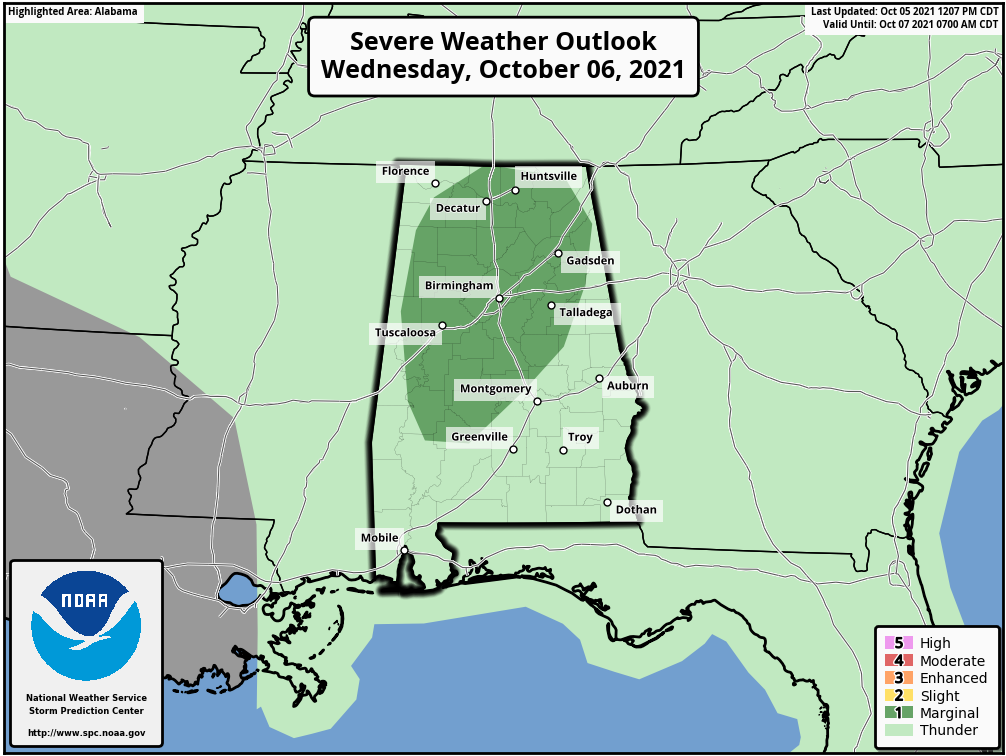
A good portion of North/Central Alabama has been included in a Marginal Risk for severe storms during the day on Wednesday, according to the latest Day 2 Severe Weather Outlook from the Storm Prediction Center. This includes the cities of Russellville, Athens, Decatur, Huntsville, Hartselle, Cullman, Guntersville, Scottsboro, and Rainsville in North Alabama, along with Gadsden, Anniston, Birmingham, Hoover, Talladega, Tuscaloosa, Alexander City, Clanton, Demopolis, and Selma in Central Alabama. The main threat will be from damaging wind gusts, but a brief tornado cannot be ruled out. Here is the text from the latest day 2 outlook:
…SUMMARY…
A few strong wind gusts or a brief tornado is possible across parts of northern and central Alabama on Wednesday.
…Synopsis…
An upper low centered over AR will lift slowly northward across the Ozark Plateau on Wednesday. Southerly deep-layer flow across the Southeast on the eastern side of the upper low and associated trough will maintain rich boundary-layer moisture across the Southeast. Scattered to numerous showers and thunderstorms will be possible in this warm advection regime across the TN Valley to the Ohio Valley.
Surface dewpoints in the upper 60s to near 70 F are forecast on Wednesday. Cloud cover and periods of ongoing showers/thunderstorms will limit heating, but MLCAPE around 750-1250 J/kg appears likely. A surface trough will be oriented roughly north to south near the AL/MS border, resulting in southeasterly low-level flow beneath south/southwesterly mid/upper level flow. While deep-layer flow is not expected to be strong, effective shear magnitudes around 25-35 kt are expected. This should aid in at least briefly organized cells amid weak instability. Backed low-level flow near/east of the surface trough axis are contributing to somewhat small, but favorably curved, low-level hodographs in forecast soundings. Given rich boundary-layer moisture and weak instability, some weak/briefly rotating cells will be possible. While weak instability and somewhat modest large-scale ascent will limit overall severe potential, at least a couple of strong gusts or perhaps a brief tornado will be possible, and a Marginal risk has been introduced to parts of northern/central AL.
Category: Alabama's Weather, ALL POSTS, Severe Weather
About the Author (Author Profile)
Scott Martin is an operational meteorologist, professional graphic artist, musician, husband, and father. Not only is Scott a member of the National Weather Association, but he is also the Central Alabama Chapter of the NWA president. Scott is also the co-founder of Racecast Weather, which provides forecasts for many racing series across the USA. He also supplies forecasts for the BassMaster Elite Series events including the BassMaster Classic.Subscribe
If you enjoyed this article, subscribe to receive more just like it.


