Another Beautiful but Very Warm Afternoon Across Central Alabama
Very similar to Saturday at this time with just a little less in the number of fair weather clouds, today’s weather for the early afternoon continues to be mainly sunny and warm for this time of year. At the 1 pm roundup, temperatures were ranging from 78 degrees in Alexander City to as warm as 85 down in Troy. Birmingham was at 83 degrees. No change for the rest of the day, as highs will reach the mid to upper 80s across the area. Skies will be clear for tonight through the overnight hours, with lows dipping into the lower to mid 60s.
Clouds will be on the increase throughout the second half of the day on Monday as a cold front will be approaching from the west, but much of the first half of the day will be mostly sunny. Highs will be in the lower to mid-80s.
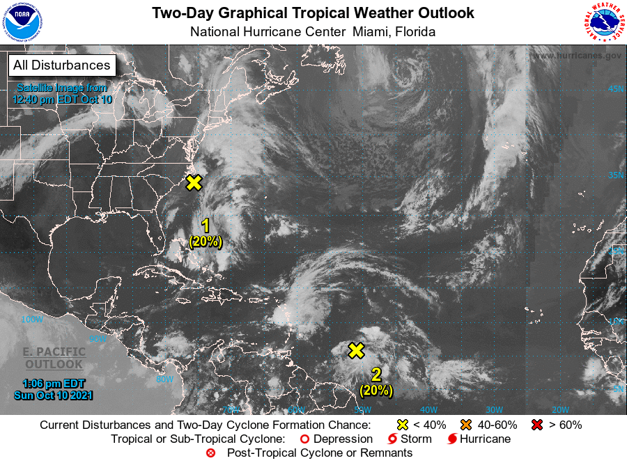
THE TROPICS
#1: Shower and thunderstorm activity remains disorganized in association with a large, non-tropical low-pressure area located about 80 miles south of Cape Hatteras, North Carolina. An Air Force Reserve reconnaissance aircraft that investigated the low earlier today found that the system was still producing a small area of gale-force winds just offshore the North Carolina outer banks. However, dry air and strong upper-level winds are expected to decrease the chance for further development of this system. The low is forecast to move slowly northeastward today, with the center remaining just offshore the eastern North Carolina coast this afternoon and tonight. Interests in that area should continue to monitor the progress of this system and refer to local National Weather Service office products for more information. Regardless of development, intermittent periods of locally heavy rains and gusty winds will affect southeastern and eastern portions of North Carolina during the next day or so.
* Formation chance through 48 hours… low… 20 percent.
* Formation chance through 5 days… low… 20 percent.
#2: Recent satellite-derived surface wind data indicate that a vigorous tropical wave located about 500 miles east-southeast of the Windward Islands is producing a concentrated area of cloudiness and thunderstorms near the wave axis. Environmental conditions are forecast to be marginally conducive for some additional development of this system while it moves west-northwestward at about 15 mph over the next few days. The disturbance is expected to approach the central and northern Lesser Antilles by late Monday and early Tuesday, and interests in these areas should monitor the progress of this system. Regardless of development, the system will produce locally heavy rainfall and gusty winds across portions of the central and northern Lesser Antilles on Tuesday, and across the Virgin Islands and northern Lesser Antilles on Wednesday.
* Formation chance through 48 hours… low… 20 percent.
* Formation chance through 5 days… low… 30 percent.
Category: Alabama's Weather, ALL POSTS, Tropical
About the Author (Author Profile)
Scott Martin is an operational meteorologist, professional graphic artist, musician, husband, and father. Not only is Scott a member of the National Weather Association, but he is also the Central Alabama Chapter of the NWA president. Scott is also the co-founder of Racecast Weather, which provides forecasts for many racing series across the USA. He also supplies forecasts for the BassMaster Elite Series events including the BassMaster Classic.Subscribe
If you enjoyed this article, subscribe to receive more just like it.


