Isolated Wind Damage Threat Across North Alabama Through the Remainder of the Afternoon
The Storm Prediction Center has issued a mesoscale discussion for all of the North Alabama counties due to the threat of strong thunderstorms that may produce isolated wind damage. For now, the strongest thunderstorm on radar is located in the southwestern corner of Winston County and was moving eastward at 20 mph. Winds up to 40 mph may occur, and some small hail may occur within this storm over the next 30-45 minutes. Here is the text from the SPC:
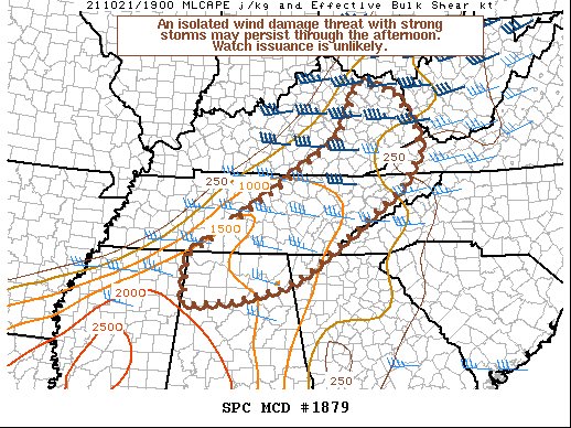
SUMMARY… An isolated wind damage threat with strong storms may persist through the afternoon. Watch issuance is unlikely.
DISCUSSION… Low-topped convection with occasional embedded lightning continues to gradually increase in coverage along/ahead of a cold front from central/eastern KY across the TN Valley. Broken cloud cover and poor mid-level lapse rates are limiting instability, with around 500-1000 J/kg of MLCAPE present per latest mesoanalysis estimates. Area VWPs show low-level winds veered to a generally west-southwesterly component, which is limiting convergence along the front. Even so, these winds do quickly strengthen with height in the 0-3 km layer owing to the presence of a mid/upper-level trough over the OH Valley. About 30-40 kt of effective bulk shear should support some updraft organization, with both cells and small clusters possible. As filtered diurnal heating continues through the remainder of the afternoon, modest steepening of low-level lapse rates may support efficient momentum transfer within convective downdrafts. Isolated strong to damaging winds of 40-60 mph should be the main threat with the developing convection for at least the next few hours. Regardless, the overall severe risk should be tempered by the marginal thermodynamic environment, and watch issuance appears unlikely at this time.
Category: Alabama's Weather, ALL POSTS, Severe Weather
About the Author (Author Profile)
Scott Martin is an operational meteorologist, professional graphic artist, musician, husband, and father. Not only is Scott a member of the National Weather Association, but he is also the Central Alabama Chapter of the NWA president. Scott is also the co-founder of Racecast Weather, which provides forecasts for many racing series across the USA. He also supplies forecasts for the BassMaster Elite Series events including the BassMaster Classic.Subscribe
If you enjoyed this article, subscribe to receive more just like it.


