

Midday Nowcast: Sunny and Nice Friday Afternoon
After the very foggy morning across the state, our Friday is featuring a sky full of sunshine and though it is cooler today, it is still a nice day to end the week with highs in the mid to upper 60s.
Tonight, another front drops into the state and will bring the much colder air mass into the state for the weekend. The front will come through in dry fashion with only some accompanying clouds. Lows tonight will be in the upper 30s and lower 40s by tomorrow morning.
FRIDAY NIGHT LIGHTS: For the high school playoff games tonight, the sky will be clear with temperatures mostly in the 40s.
COLDER WEEKEND WEATHER: Tomorrow will be a sunny day, but much cooler with highs in the lower 50s. It will be breezy with northerly winds of of 10-20 mph, which will make it feel colder at times. As we head into tomorrow night, growers beware, temperatures are going to fall into the upper 20s and lower 30s across much of North/Central Alabama by Sunday morning and a Freeze Watch has been issued for much of the state.
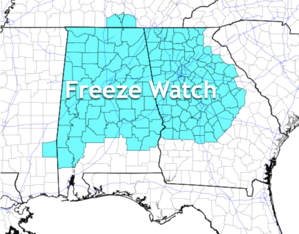
This will be upgraded to a Freeze Warning tomorrow, you will need to protect sensitive vegetation, as this will likely bring an end to the growing season across much of the state. After the freezing start to Sunday, the day will be sunny with highs in the upper 50s.
NEW MEXICO STATE AT ALABAMA (11:00a CT kickoff at Bryant-Denny Stadium): Expect a sunny sky with temperatures rising from near 48 at kickoff, into the mid 50s by the second half.
MISSISSIPPI STATE AT AUBURN (11:00a CT kickoff at Jordan-hare Stadium): With a sunny sky, temperatures will rise from 50 degrees at kickoff, to near 56 by the final whistle.
BEACH FORECAST CENTER: Get the latest weather and rip current forecasts for the beaches from Fort Morgan to Panama City on our Beach Forecast Center page. There, you can select the forecast of the region that you are interested in visiting.
WORLD TEMPERATURE EXTREMES: Over the last 24 hours, the highest observation outside the U.S. was 109.8F at Mariental, Namibia. The lowest observation was -69.2F at Vostok, Antarctica.
CONTIGUOUS TEMPERATURE EXTREMES: Over the last 24 hours, the highest observation was 96F at Camp Pendleton, CA. The lowest observation was 11F at Rocky Boy, MT.
WEATHER ON THIS DATE IN 2003: Thunderstorms developed in southern California and produced torrential downpours across parts of the Los Angeles area. More than 5 inches of rain fell in just 2 hours in southern Los Angeles, producing severe urban flooding. Small hail also accompanied the storms, accumulating several inches deep in some areas of the city. Nearly 115,000 electrical customers lost power as the storms affected the area.
Category: Alabama's Weather, ALL POSTS
About the Author (Author Profile)
Macon, Georgia Television Chief Meteorologist, Birmingham native, and long time Contributor on AlabamaWX. Stormchaser. I did not choose Weather, it chose Me. College Football Fanatic. @Ryan_StinnetSubscribe
If you enjoyed this article, subscribe to receive more just like it.


