Sunday Weather Xtreme: Clouds Early Today, Giving Way to a Nice Week Ahead
FOR YOUR SUNDAY: Clouds have increased across the area from the west as an upper-level disturbance approached from the west. A few showers are accompanying the shortwave, but the air is too dry except for a few sprinkles across the central part of the state. Showers are more likely to the south. Highs this afternoon will be in the upper 50s to lower 60s. Skies should gradually clear during the day. Overnight lows tonight will be in the upper 20s across North Alabama, with readings near or just below freezing across North Central Alabama.
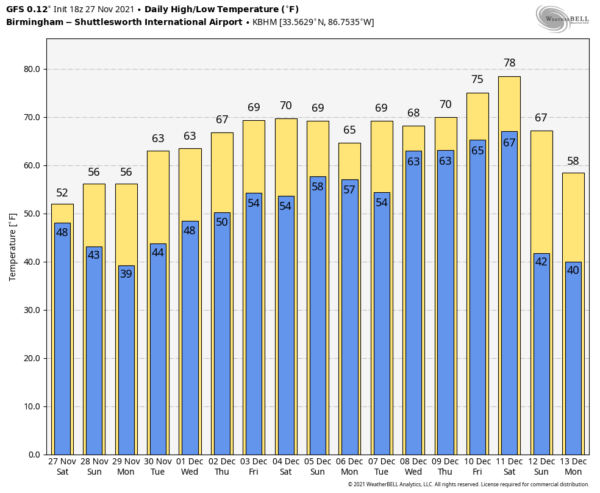
BACK TO WORK: High pressure begins to take over by tomorrow, and that spells good weather for us here in Alabama. There will be a gradual warming trend through the week, with mostly sunny to partly cloudy skies. Highs will warm from the 50s tomorrow through the 60s all week, targeting the upper 60s by Friday. Lows will warm from the 40s Tuesday and Wednesday into the s for the remainder of the workweek.
WEEKEND OUTLOOK: Another disturbance in the southern stream will bring a chance of showers to Alabama by Saturday or Saturday night. If we escape the rain during the day, Saturday could be a pretty nice day with highs in the lower 70s.
VOODOO TERRITORY: Out at the end of the forecast period around Saturday the 11th, a stronger system will bring another chance of showers to Alabama. That will be followed by a second even stronger system that will eventually lead to much colder weather for much of the country.
BEACHCAST: A few showers today along the beautiful beaches of Alabama and Northwest Florida, thanks to our fast-moving upper-level disturbance. But it has been a very nice Holiday week, and another nice one is in store. The next rain chances won’t come until next weekend. High temperatures will warm from the upper 50s today, rising into the upper 60s and lower 70s by next weekend. Lows will be in the 40s tomorrow morning but will rise through the 50s into the lower 60s by next weekend. Water temperatures are in the lower 60s now.
Click here to see the Beach Forecast Center page.
NATIONALLY: Quiet nationally, although parts of the Northeast did receive their first heavy snowfall Friday night. Six to ten inches of snow fell across the Adirondacks, Green, and White Mountains of New Hampshire and Vermont.
DANCING WITH THE STATS: 47F was the low temperatures on Friday in Billings MT. That was the warmest November 26th on record there. But a change is a-comin’. Big time cold toward the middle of the month will flip the field, with the GFS predicting -16F there on the morning of the 13th.
IN THE TROPICS: The Atlantic Hurricane Season is ending with a whimper, as we have still to see a named storm since Wanda became post-tropical on November 7th. It will go down in the record books as a very busy season, with 21 named storms. Seven of them reached hurricane status, and 4 attained major hurricane status (category 3 or higher). No Cat Five storms this year, but Ida was awfully close, and caused tremendous damage in southeastern Louisiana.
ADVERTISE WITH US: Deliver your message to a highly engaged audience by advertising on the AlabamaWX.com website. The site enjoyed nearly 26 MILLION page views in the past 12 months. Don’t miss out! We can customize a creative, flexible, and affordable package that will suit your organization’s needs. Contact me, Bill Murray, at (205) 687-0782, and let’s talk.
WEATHERBRAINS: A great show this past week on the podcast that’s all about weather. The crew entertained Tristan Gooley, a British author, and Natural Navigator. Tune in for some tips on interacting with your surroundings. This week, the panel will entertain storm chaser and photographer Mike Olbinski. Check out the show at www.WeatherBrains.com. You can also subscribe on iTunes. You can watch the show live at live.bigbrainsmedia.com or on James’ YouTube Channel You will be able to see the show on the James Spann 24×7 weather channel on cable or directly over the air on the dot 2 feed.
ON THIS DATE IN 1921: New England was in the midst of a four-day ice storm, their worst of record. Ice was more than three inches thick in many places following the storm, and property damage was in the millions of dollars. Northern New England received heavy snow with more than two feet reported in some areas. Overnight freezing rains continued through the day at Worcester MA while the wind increased to a gale. Streets become impassable even on foot, and whole towns were plunged into darkness without communication. The storm caused 20 million dollars of damage to power lines, telephone lines and trees. Follow my weather history tweets on Twitter. I am @wxhistorian at Twitter.com.
Category: Alabama's Weather, ALL POSTS


