Severe Threat Continues for Locations South of US-80 & I-85
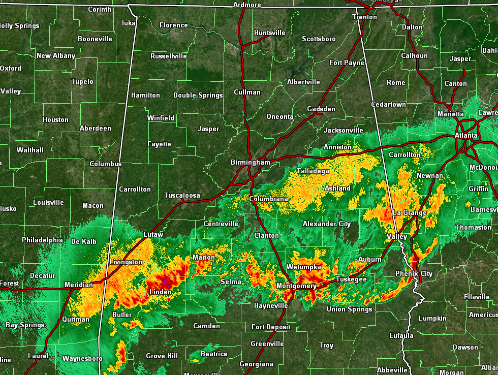
As of 1:15 pm, the line of rain and storms have become more horizontal in nature as far as in orientation on radar, and that usually means that the front has now lost the influence from the better dynamics off to the northeast. As far as the severe threat, it has ended for locations along and north of the I-85 and US-80 corridors, while a few strong wind gusts and a very small chance of a brief spin-up tornado remain possible south of that. The cooler air has already started to invade from the northwest, as temperatures are currently ranging from the lower 50s to the upper 70s. It is 52 degrees in Haleyville while at the same time it is 79 degrees down in Troy. Birmingham was at 63 degrees.
Here is the latest Mesoscale Discussion from the SPC:
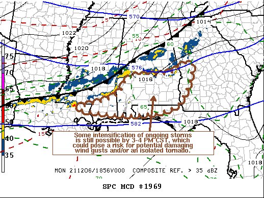
SUMMARY… Some intensification of thunderstorm development is still possible late this afternoon, particularly across parts of south central through southeastern Alabama by 3-4 PM CST. While this may be accompanied by the risk of a few strong wind gusts and/or, perhaps, a tornado, it still seems unlikely that a severe weather watch will be needed. Trends, however, will continue to be monitored.
DISCUSSION… There has been some weak boundary-layer destabilization ahead of the line of more vigorous thunderstorm development, which continues to advance southward near/just ahead of the cold front. Convection along the line appears to have been periodically enhanced by subtle mid-level perturbations/speed maximum within the weak branch of westerlies emanating from the subtropical Pacific. However, the primary mid-level short wave impulse, within the mid-latitude westerlies, is passing well to the northeast of the region, and deep-layer mean wind fields are generally maintaining modest strength or slowly weakening across the Gulf Coast vicinity.
Still, a lingering belt 30-40 kt west-southwesterly to westerly flow in the 850-700 mb layer, coincident with the line of storms, may be sufficient to maintain continuing risk for a few strong surface gusts and/or an isolated tornado through the remainder of the afternoon. With further boundary-layer destabilization still possible, there might be some intensification of ongoing storms, particularly across parts of south central through southeastern Alabama by 21-22Z.
Category: Alabama's Weather, ALL POSTS, Severe Weather
About the Author (Author Profile)
Scott Martin is an operational meteorologist, professional graphic artist, musician, husband, and father. Not only is Scott a member of the National Weather Association, but he is also the Central Alabama Chapter of the NWA president. Scott is also the co-founder of Racecast Weather, which provides forecasts for many racing series across the USA. He also supplies forecasts for the BassMaster Elite Series events including the BassMaster Classic.Subscribe
If you enjoyed this article, subscribe to receive more just like it.


