An Update on the Alabama Weather Situation at 6:15 p.m.
We are preparing for an active severe weather setup through the overnight hours into Saturday across Alabama and the Mid-South.
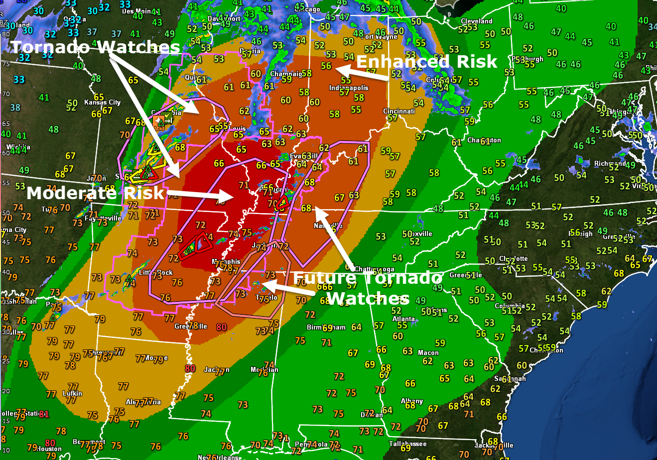
Tornado watches cover a large area from eastern Missouri and western Illinois, into western Kentucky, western Tennessee, northwestern Mississippi, and into much of Arkansas.
Right now, two main areas of development are occurring. The other is back near the cold front, over Central Missouri. Several severe thunderstorm warnings are in effect southwest of St. Louis.
The other extends from southern Illinois, into western Kentucky, western Tennessee, eastern Arkansas, and northern Mississippi. Storms are increasing rapidly in this area. A tornado warning continues for areas just northwest and north of Murray KY. That storm is heading in the general direction of Hardin and eventually Madisonville. Another tornado warning was just issued for areas southwest of Jonesboro AR.
A new tornado watch will be coming soon for parts of Middle Tennessee into western Kentucky.
There could be strong tornadoes this evening in the Moderate and Enhanced Risk area.
We are seeing a good bit of development over northeastern Mississippi, where no watch is in effect yet. The tornado watch may have to be extended eastward into northeastern Mississippi soon.
Across Alabama, things are quiet. A warm front is pushing northeastward out of our state. Temperatures are still in the 50s with lots of fog and low clouds across parts of Etowah, DeKalb, and Jackson counties. It is 68F at BHM and 75F at Tuscaloosa. Temperatures will remain steady overnight.
That fog will gradually move out as the warm front moves out of the state.
It will be windy overnight with winds gusting to 35 mph here. Wind advisories are in effect.
There could be a few showers and some storms overnight. There is a good deal of helicity already, so the storms will be spinning, but not really expecting severe storms through midnight.
Storms will reach the northwest corner of Alabama around 4-5 a.m. Huntsville to Jasper around 6-7 a.m. They will reach I-59 around 10-11 a.m. They will reach areas from Anniston to Talladega to Montgomery by 11 a.m. to noon.
The storms will have the chance to produce damaging winds gusts and isolated, brief tornadoes across Alabama. The greatest threat is for the northwest corner of the state, with a lesser threat the further southeast you go.
The rain will hang on for a while during the day tomorrow behind the front. Rain will continue across much of Central Alabama through the afternoon and into the evening. Temperatures will fall slowly behind the front. Lows Saturday night will be in the 30s.
Get ready for a nice run of weather next week.
Category: Alabama's Weather, ALL POSTS, Severe Weather
About the Author (Author Profile)
Bill Murray is the President of The Weather Factory. He is the site's official weather historian and a weekend forecaster. He also anchors the site's severe weather coverage. Bill Murray is the proud holder of National Weather Association Digital Seal #0001 @wxhistorianSubscribe
If you enjoyed this article, subscribe to receive more just like it.


