Sunday Weather Xtreme: Much Cooler Today
Saturday’s storms across Alabama were well behaved. There was one damaging wind report in Coffee County near New Brockton. There were some reports of large hail and even a possible tornado in southeastern Texas, but we came through just fine.
CHANGE TO COLDER: Yesterday was a muggy and warm day, with occasional showers. Things have changed this morning. Temperatures are in the 30s over Northwest Alabama and the Tennessee Valley as we start the day, with 40s across the I-59 Corridor, and 50s to the south. There are a few 60s over the Wiregrass region of Southeast Alabama. There are a few straggling showers in the I-85 Corridor. All of the showers should be gone by late morning. Highs today will be in the 40s northwest of I-59, with readings falling after mid-afternoon. 50s will be prevalent over South Alabama. Lows tonight will be below freezing over the Tennessee Valley and much of North Alabama, with readings in the 30s across the rest of North and South Central Alabama. 40s will be found over far South Alabama.
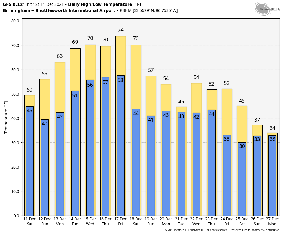
HYBRID STORM IN THE GULF: The tail of the frontal system that is bringing us our colder weather will stall over the western Gulf of Mexico today. By early Monday, low pressure will form and move east northeast across the Gulf. Showers and storms will affect the Gulf Coast and South Alabama on Monday and Tuesday. We could see a stray shower over Central Alabama Monday as well on Tuesday. The low will bring wind and rain to the Florida Peninsula late Monday and Tuesday.
OUR HOLIDAY WEEK WEATHER: Monday and Tuesday will be mostly cloudy with highs in the 50s and lows in the 40s Tuesday morning and 30s Wednesday morning as colder air filters in on the backside of the departing low. Wednesday should feature more sunshine, with highs in the upper 50s.
CHRISTMAS EVE AND CHRISTMAS DAY: High pressure will begin building in by Thursday and Friday. The result will be mostly sunny to partly cloudy skies with temperatures warming into the 60s.
WEEKEND OUTLOOK: More high pressure and fine weather for the weekend. Highs will be in the upper 60s to near 70F. Lows will be in the 50s.
THE WEEK AFTER CHRISTMAS: There is a lot of uncertainty heading into the week after Christmas. It looks like a frontal system will bring colder weather by the middle of the week, but temperatures should rebound before the end of the year.
BEACH FORECAST: Get the latest weather and rip current forecasts for the beaches from Dauphin Island, AL, to Panama City Beach, FL, on our Beach Forecast Center page. There, you can select the forecast of the region that you are interested in.
THE BLOG: We had a record-breaking year in 2020 with over 20 million page views! We are on a record-shattering pace to break that mark, as we are already over 17.4 million page views through the first half of 2021! Don’t miss out! We can customize a creative, flexible, and affordable package that will suit your organization’s needs. Contact Bill Murray at (205) 687-0782.
E-FORECAST: Get the Alabama Weather Blog’s Seven-Day Forecast delivered directly to your inbox by email twice daily. It is the most detailed weather forecast available in Central Alabama. Subscribe here… It’s free!
CONNECT WITH THE BLOG ON SOCIAL MEDIA: You can find the AlabamaWx Weather Blog on Facebook and Twitter.
WEATHERBRAINS: WeatherBrains is the official netcast for people who love weather featuring our very own James Spann and Bill Murray, along with notable geeks such as Troy Kimmel, Aubrey Urbanowicz, Jen Narramore, Rick Smith, Dr. Neil Jacobs, and Kim Klockow-McClain. They bring together a wealth of weather knowledge and experience for a fascinating netcast about the weather. Watch live starting at 7:00 pm CT on Monday nights at live.bigbrainsmedia.com or live on James Spann’s YouTube channel. Listeners can find the recorded audio versions at WeatherBrains.com or on your favorite podcast platform (Apple Podcasts, Stitcher, Spotify, etc.).
ON THIS DATE IN 2002: A short-lived but powerful tornado ripped through the small town of Newton, Mississippi during the early afternoon, hitting a Wal-Mart store. The tornado injured 60 people. A tanker truck was blown off Interstate 20, causing a diesel spill that closed the highway. A tornado watch and severe thunderstorm warning was in effect for Newton when the tornado struck. The call to action message in the warning stated that tornadoes can form quickly from severe thunderstorms. Follow my weather history tweets. I am @wxhistorian.
Category: Alabama's Weather, ALL POSTS
About the Author (Author Profile)
Bill Murray is the President of The Weather Factory. He is the site's official weather historian and a weekend forecaster. He also anchors the site's severe weather coverage. Bill Murray is the proud holder of National Weather Association Digital Seal #0001 @wxhistorianSubscribe
If you enjoyed this article, subscribe to receive more just like it.


