Tornado Watch Likely to Be Issued Within the Next 1-2 Hours
The Storm Prediction Center has released a Mesoscale Discussion that points to the potential of a Tornado Watch being issued within the next couple of hours for the northern half of Mississippi and into the northwestern parts of North/Central Alabama. Here is the text from the discussion:
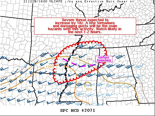
SUMMARY… The severe thunderstorm threat is expected to increase by 18z. Supercells and bowing segments producing a few tornadoes, damaging gusts and isolated large hail are expected with this activity. A watch is likely by around 18z
DISCUSSION… An area of showers and isolated thunderstorms across parts of northern MS/AL and south-central TN will continue to shift east/northeast through early afternoon in a strong warm advection regime. Airmass recovery in the wake of this activity is evident across parts of northwest MS into southeastern AR where cloud breaks are allowing for greater heating. Temperatures to the west and south of morning precipitation generally are in the low 70s, with upper 60s to low 70s F dewpoints. This is allowing or rather quick destabilization, with MLCAPE values quickly increasing to around 500-1000 J/kg. This trend should continue with northeast extent across the MCD area as morning precipitation continues to clear.
A surface boundary associated with morning convection extends across parts of southeast AR into northern MS/AL and may serve as a focus for greater severe thunderstorms potential by early afternoon. A couple rounds of severe storms may be possible as initial supercell storms develop in the vicinity of this surface boundary within the open warm sector, while additional convection spreads eastward from AR/LA associated with the surface low and cold front. Strong vertical shear, with effective shear magnitudes greater than 50 kt, and a southwesterly low level jet increasing to around 40-50 kt through the day will support supercells. A few tornadoes, one or two of which could be strong, damaging gusts and isolated large hail is expected with this activity. With time, convection may develop into one or more bowing segments closer to the front/surface low. As this occurs, the threat for damaging wind gusts will increase, with a continued threat for mesovortex tornadoes given favorable low level shear and rich boundary-layer moisture. A watch will likely be needed by around 18z.
Category: Alabama's Weather, ALL POSTS, Severe Weather
About the Author (Author Profile)
Scott Martin is an operational meteorologist, professional graphic artist, musician, husband, and father. Not only is Scott a member of the National Weather Association, but he is also the Central Alabama Chapter of the NWA president. Scott is also the co-founder of Racecast Weather, which provides forecasts for many racing series across the USA. He also supplies forecasts for the BassMaster Elite Series events including the BassMaster Classic.Subscribe
If you enjoyed this article, subscribe to receive more just like it.


