Threat for Damaging Winds & a Brief Tornado Remains Possible Ahead of the Front
Here is the latest from the SPC’s Mesoscale Discussion:
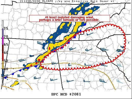
SUMMARY… Storms moving out of Tennessee and Alabama may continue to pose a damaging wind and brief tornado threat.
DISCUSSION… A long-lived line of storms currently extends from far eastern TN into northeast AL, with QLCS structures observed on radar with a brief tornado possibly occurring in DeKalb County, AL.
Surface analysis shows mid 60s F dewpoints have spread into the Atlanta area, with low 60s F approaching western NC. This is resulting in sufficient SBCAPE to sustain a damaging wind and tornado risk, as shear remains strong. 0-1 SRH of 250-300 m2/s2 currently resides ahead of the line of storms, and strongly favors low-level rotation. As such, the QLCS tornado and wind risk is expected to continue eastward, and a new watch may be necessary soon.
Category: Alabama's Weather, ALL POSTS, Severe Weather
About the Author (Author Profile)
Scott Martin is an operational meteorologist, professional graphic artist, musician, husband, and father. Not only is Scott a member of the National Weather Association, but he is also the Central Alabama Chapter of the NWA president. Scott is also the co-founder of Racecast Weather, which provides forecasts for many racing series across the USA. He also supplies forecasts for the BassMaster Elite Series events including the BassMaster Classic.Subscribe
If you enjoyed this article, subscribe to receive more just like it.


